AQUASTAT - FAO's Global Information System on Water and Agriculture
Cape Verde
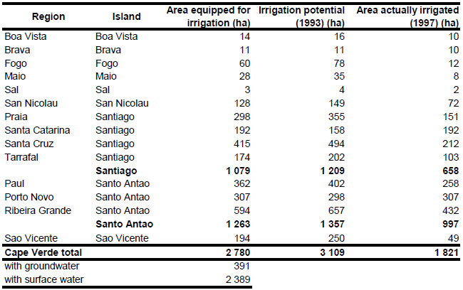
Area equipped for irrigation is 2 780 ha, while the area actually irrigated was 1 821 ha. The figures refer to year 1997. Irrigation potential was estimated at 3 109 ha in 1993. Irrigation potential and area actually irrigated were available per island and region [CV01]. Area equipped for irrigation per island and region was estimated as area actually irrigated + 0.7211 * (irrigation potential – area actually irrigated) with the exception of the regions Santa Catarina and Porto Novo. For these regions the area equipped for irrigation was set to the value reported for area actually irrigated because the irrigation potential reported for the year 1993 was lower here than the area actually irrigated in 1997. The irrigated area per region estimated that way is visible in the table below and also can be downloaded as Cape Verde irrigation areas in PDF or Cape Verde irrigation areas in Excel.
Irrigated area was assigned to grid cells according to the GLC2000 land cover map for Africa [CV02] considering all areas classified as "Croplands with open woody vegetation".
22 percent (391 ha) of the area equipped for irrigation is irrigated with groundwater [CV01].
References
[CV01]: Ministère de l’agriculture de l’élevage et de la sylviculture. 1997. Plan national directeur de l’irrigation – Cap Vert.
[CV02]: Mayaux, P., Bartholomé, E., Cabral, A., Cherlet, M., Defourny, P., Di Gregorio, A., Diallo, O., Massart, M., Nonguierma, A., Pekel, J.-F., Pretorius, C., Vancutsem, C., and Vasconcelos, M. 2003. The Land Cover Map for Africa in the Year 2000. European Commision Joint Research Centre, available at: http://www-gem.jrc.it/glc2000).


