AQUASTAT - FAO's Global Information System on Water and Agriculture
Costa Rica
Areas equipped for irrigation in Costa Rica add up to 103 084 ha [CR01]. The figures per region originate from the AQUASTAT-library and refer to 1997 but are in good agreement to more recent estimates reporting a total area equipped for irrigation of 101 500 ha [CR02].
The distribution of irrigated areas within the provinces is based on a World Bank study on private irrigation from the year 1993 [CR03]. 54 irrigation projects were identified and 22 600 ha irrigated area was assigned to these projects. The Arenal Tempisque irrigation scheme (28 000 ha), which is the largest irrigation project in the country and mainly used to produce rice and sugar cane, was digitized from satellite imagery by using the maps provided by SENARA [CR04]. The remaining area equipped for irrigation was equally distributed over area classified as “Agro-productive system” in the Central American Ecosystems Map [CR05]. The irrigated area per province is visible in the table below and also can be downloaded as Costa Rica irrigation areas in PDF or Costa Rica irrigation areas in Excel.
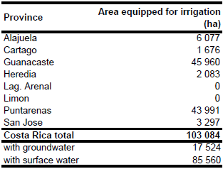
Area actually irrigated was assumed to be similar to area equipped for irrigation [CR01]. Area equipped for irrigation with groundwater was 17 524 ha (17 percent of total AEI) [CR01]. Data on concessions for irrigation water withdrawals granted by the Water Department of the Environmental Ministry indicate a lower contribution of groundwater irrigation with only 2 percent of the concessions for groundwater. Illegal extraction of water might be one reason for the differences to the FAO data [CR06].
References
[CR01]: FAO. 2000. AQUASTAT country profile of Costa Rica. FAO, Rome, Italy.
[CR02]: Ministro de Ambiente, Energía y Telecomunicaciones. 2008. Plan Nacional de Gestión Integrada de los Recursos Hídricos (PNGIRH). MINAET, http://www.inec.go.cr/A/MT/Medio Ambiente/Publicación/C1/2.1.1 Plan Nacional para la Gestión Integrada del Recurso Hídrico/Gestión Integrada del Recurso Hírico.pdf, 27/02/2012.
[CR03]: World Bank. 1993. Central America - Subsector Study on private irrigation. Report No. 12097-LAC, World Bank, Washington, D.C., USA.
[CR04]: SENARA. 2012. Distrito de riego Arenal Tempisque. Servicio Nacional de Aguas Subterráneas Riego y Avenamiento (SENARA), http://www.senara.or.cr/direccion distrito de riego arenal tempisque/Distrito de Riego Arenal Tempisque. html, 27/02/2012.
[CR05]: World Bank and CCAD. 2001. Ecosystems of Central America (ArcView regional map files at 1:250,000). World Bank, Comisión Centroamericana de Ambiente y Desarrollo (CCAD), World Institute for Conservation and Environment (WICE), and the Centro Agronómico Tropical de Investigación y Enseñanza (CATIE), Washington, D.C., http://www.birdlist.org/cam/themes/ map_download_page.htm, 15/11/2010.
[CR06]: Ballestero, M., Reyes, V., & Astorga, Y. 2007. Groundwater in Central America: its importance, development and use, with particular reference to its role in irrigated agriculture. In: Giordano, M. & Villholth, K. G., The agricultural groundwater revolution. Opportunities and threads to development. International water Management Institute (IWMI), Colombo, Sri Lanka, 100-128, http://www.iwmi.cgiar.org/Publications/CABI\_Publications/index.aspx, 12/08/2009.


