AQUASTAT - FAO's Global Information System on Water and Agriculture
Cuba
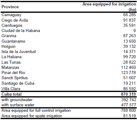
The total area equipped for irrigation in Cuba equals 870 319 ha [CU01]. The figures per province originate from the AQUASTAT-library and refer to 1996 and 1997. The irrigated area per province is visible in the table below and also can be downloaded as Cuba irrigation areas in PDF or Cuba irrigation areas in Excel.
Maps showing irrigated areas were not available for Cuba. The area under irrigated rice cultivation was taken from a continental study on the distribution of rice in Latin America [CU02]. The rest of the irrigated area was distributed within the provinces on the basis of land use maps [CU03].
AAI declined from 822 225 ha in 1997 [CU01] to 180 900 ha in year 2007 [CU04]. In year 1997 about half of the AEI was irrigated with groundwater [CU01]. It was assumed that the percentage of AEI irrigated with groundwater in year 2007 was similar to the percentage reported for year 1997.
References
[CU01]: FAO. 2000. AQUASTAT country profile of Cuba. FAO, Rome, Italy.
[CU02]: Academica de Ciencias de Cuba. 1997. Nuevo Atlas National de Cuba, P. XVI. 1.2-3 (uso de la Tierra).
[CU03]: CIAT. 1997. Distribution of rice in Latin America. http://www.gis.ciat.cgiar.org or http://www.grida.no/prog/global/cgiar/.
[CU04]: ONE. 2008. Panorama Uso de la Tierra 2007. Oficina Nacional de Estadísticas (ONE), Habana, Cuba, http://www.one.cu/PublicacionesDigitales/FichaPublicacion.asp? CodPublicacion=13&CodDireccion=5, 17/08/2009.


