AQUASTAT - FAO's Global Information System on Water and Agriculture
Czech Republic
During the last century irrigation infrastructure was built on about 155 000 ha of agricultural land. Area equipped for irrigation was at its maximum in the period 1995-1997 at 132 401 ha [CZ01]. Area actually irrigated was largest in 1988 (99 115 ha) and declined later to about 48 000 ha at the beginning of the 1990s, about 35 000 ha in the mid 90s and 16 238 ha in 1997 [CZ02]. Irrigation is nowadays only being used for crops that cannot be grown without irrigation or for those for which irrigation generates high added value (vegetables, hop-fields, orchards, vineyards and potatoes). EUROSTAT reported areas actually irrigated of 16 870 ha in 2003 and 17 320 ha in 2005 [CZ03]. The low figures of area actually irrigated in the last ten years indicate that a large part of the former irrigation infrastructure seems to be dead and no longer useable. Therefore area equipped for irrigation was estimated for eight regions by choosing the maximum of the irrigable areas as reported by EUROSTAT for the years 2003 and 2005 [CZ03]. Area equipped for irrigation per region estimated that way is summing up to 50 590 ha. It is visible in the table below and also can be downloaded as Czech Republic irrigation areas in PDF or Czech Republic irrigation areas in Excel.
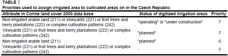
The main irrigation areas of the country were digitized from an irrigation map. The map showed areas in operation, areas under construction and planned irrigation areas [CZ04]. Additionally a large irrigation area was digitized in the surrounding of Znojmo in South Moravia [CZ05]. Irrigated area was then assigned to cultivated land extracted from the Corine 2000 land cover data base for Europe [CZ06] using the priorities shown in Table 1. In the regions of Jihozápad and Strední Morava irrigated area was assigned to all areas classified as vineyards (221), fruit trees and berry plantations (222) or complex cultivation patterns (242) because none of the digitized irrigation areas was located within these regions.
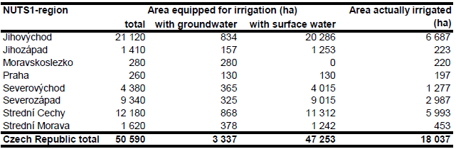
Area equipped for irrigation with groundwater was computed based on the data collected by the EU farm structure survey 2003 as described before. Area actually irrigated was computed for each region as average of AAI reported by the EU farm structure surveys 2003, 2005 and 2007 [CZ03]. AAI per region estimated that way is summing up to 18 037 ha.
References
[CZ01]: Štastná, M., Miškovský, J., Cermák, J., Doležal, F., Zavadil, J. & Spitz, P. 2006. Country report from Czech Republic. In: Dirksen, W. and Huppert, W. (ed.). Irrigation sector reform in Central and Eastern European countries. Deutsche Gesellschaft für Technische Zusammenarbeit (GTZ), Eschborn, Germany, 103-118.
[CZ02]: Miskovsky, J. 2002. Privatisation of irrigation systems in the Czech Republic. EWRG letter 12, 3-6.
[CZ03]: Statistical Office of the European Communities (EUROSTAT). 2011. Irrigable and irrigated areas. http://epp.eurostat.ec.europa.eu/portal/ page/portal/agri_environmental_indicators/data/ database, 28/11/2011.
[CZ04]: Framji, K.K., Garg, B.C. & Luthra, S.D.L. 1981. Irrigation and drainage in the world. Third edition. Vol. I, p. 304. New Delhi, ICID.
[CZ05]: Ministry of Agriculture. 2004. General information about water management in the Czech Republic. Prague, Czech Republic, 14 pp., http://www.mze.cz/, 19/07/2006.
[CZ06]: EEA. 2005. Corine land cover 2000 - vector by country (CLC2000), version 1. http://dataservice.eea.europa.eu/dataservice/metadetails.asp?id=667, 29/08/2005.


