AQUASTAT - FAO's Global Information System on Water and Agriculture
Denmark
AEI and AAI for 12 regions were derived from the EU farm structure survey 2003 [DK01]. Irrigated areas per region are summing up to 448 818 ha (AEI) and 204 070 ha (AAI). It is visible in the table below and also can be downloaded as Denmark irrigation areas in PDF or Denmark irrigation areas in Excel.
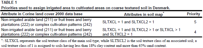
Maps showing the location of irrigation areas in Denmark were not available but it was reported that irrigation is mainly used in horticulture or to grow semi-intensive or intensive field crops like maize, potatoes and sugar beets on coarse textured or shallow soils ([DK02], [DK03]). Irrigated area was therefore assigned to all regions of coarse soil texture [DK04] classified as non-irrigated arable land (211), fruit trees and berry plantations (222) or complex cultivation patterns (242) in the Corine 2000 land cover data base for Europe [DK05] by using the priorities shown in Table 1.
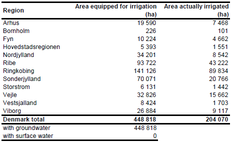
According to the data released by the EU farm structure survey 2003 all irrigation is from groundwater.
References
[DK01]: Statistical Office of the European Communities (EUROSTAT). 2011. Irrigable and irrigated areas. http://epp.eurostat.ec.europa.eu/portal/ page/portal/agri_environmental_indicators/data/ database, 28/11/2011.
[DK02]: Baldock, D., Caraveli, H., Dwyer, J., Einschütz, S., Petersen, J.E., Sumpsi-Vinas, J., Varela-Ortega, C. 2000. The environmental impacts of irrigation in the European Union. A report to the Environment Directorate of the European Commission, 147 pp., http://ec.europa.eu/environment/agriculture/, 07/07/2006.
[DK03]: Danish Environmental Protection Agency. 2004. Nature & Environment 2003 – Theme: Water in Denmark. http://www.mst.dk/homepage/default.asp?Sub=http://www.mst.dk/udgiv/ Publications/2004/87-7614-3805/html/helepubl_eng.htm#kap01_eng, 07/07/2006.
[DK04]: The Commission of the European Communities, Directorate General for Agriculture, Coordination of Agricultural Research. 1985. Soil Map of the European Communities at 1:1 000 000. The Office for Official Publications of the European Communities, ISBN 92-825-5427-9, L-2985 Luxembourg, 124 pages, http://www.grid.unep.ch/data/, 07/07/2006.
[DK05]: EEA. 2005. Corine land cover 2000 - vector by country (CLC2000), version 1. http://dataservice.eea.europa.eu/dataservice/metadetails.asp?id=667, 29/08/2005.


