AQUASTAT - FAO's Global Information System on Water and Agriculture
Ecuador
According to results of the agricultural census 2000 [EC01], area equipped for irrigation in Ecuador is 853 332 ha. This is in good agreement with data presented in the AQUSTAT country profile [EC02], reporting an AEI of 863 370 ha in year 1997. Most of the irrigated area is concentrated in the western part of the country.
The irrigated area within the 221 cantons was distributed based on a maps showing the outlines of 70 irrigated areas in 1993 [EC03] and 1997 [EC04]. Additional area for irrigated rice cultivation was taken from a continental study on the distribution of rice in Latin America [EC05]. The remaining irrigated land was assigned areas classified as cropland in the GLC2000 land cover data set [EC06]. The irrigated area per province is visible in the table below and the area per province and per canton also can be downloaded as Ecuador irrigation areas in PDF or Ecuador irrigation areas in Excel.
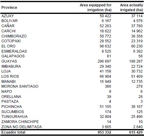
Area equipped for irrigation with groundwater was 105 120 ha in year 2000 and derived for each of the cantons from the agricultural census data base [EC01]. Since the agricultural census database did not distinguish between equipped and actually irrigated areas it was assumed that the fraction AAI /AEI was similar to the fraction reported in the AQUASTAT country questionnaire per province for year 1997. This resulted in total area actually irrigated of 615 429 ha.
References
[EC01]: INEC. 2008. Base de Datos Censo Nacional Agropecuario 2000. Instituto Nacional de Estadística y Censos (INEC), http://www.inec.gov.ec/web/guest/ecu\_est/est\_agr/ cen_agr?doAsUserId=W9NEZWtSVLU%253D, 18/08/2009.
[EC02]: FAO. 2000. AQUASTAT country profile of Ecuador. FAO, Rome, Italy.
[EC03]: INHERI. 1993. Mapa de Ubicacion de los Sistemas de Riego del Ecuador. Map available from the AQUASTAT library.
[EC04]: CNRH-Direccion de Planificacion. 1997. Inventario de Proyectos de Riego. Report available from the AQUASTAT library.
[EC05]: CIAT. 1997. CIAT. 1997. Distribution of rice in Latin America. http://www.gis.ciat.cgiar.org or http://www.grida.no/prog/global/cgiar/.
[EC06]: Eva, H.D., de Miranda, E.E., Di Bella, C.M., Gond, V., Huber, O., Sgrenzaroli, M., Jones, S., Coutinho, A., Dorado, A., Guimarães, M., Elvidge, C., Achard, F., Belward, A.S., Bartholomé, S., Baraldi, A., De Grandi, G., Vogt, P., Fritz, S. & Hartley, A. 2003. The land cover map for South America in the year 2000. GLC2000 database, European Commision Joint Research Centre, http://www-gem.jrc.it/glc2000, 10/08/2006.


