AQUASTAT - FAO's Global Information System on Water and Agriculture
Eritrea
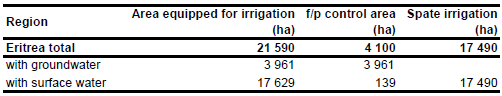
The total area equipped for irrigation is 21 590 ha. About 4 100 ha are equipped for full/partial control irrigation and 17 490 ha for spate irrigation [ER01]. The figures relate to year 1993. No sub-national statistics for irrigated land were available. The irrigated area estimated that way is visible in the table below and also can be downloaded as Eritrea irrigation areas in PDF or Eritrea irrigation areas in Excel.
540 ha irrigated area was assigned to the location of the Northern Horticulture Development Project as derived from the FAO irrigation project database for Africa [ER02]. Additionally irrigated area was assigned to all areas classified as irrigated by AFRICOVER [ER03].
The percentage of groundwater use in full/partial control schemes was 96.6 percent or 3 961 ha in year 1993 [ER04]. Area actually irrigated was about 62.5 percent of the equipped area in year 1993 [ER04].
References
[ER01]: FAO. 2005. AQUASTAT country profile Eritrea. FAO, Rome, http://www.fao.org/ag/agl/aglw/AQUASTAT/countries/index.stm, 08/11/2005.
[ER02]: FAO. 1987 (updated in 2005). Irrigated areas in Africa. FAO, Rome, Italy.
[ER03]: FAO. 2005. AFRICOVER, Eritrea - Spatially Aggregated Multipurpose Landcover database. FAO, Rome, Italy, http://www.africover.org, 13/12/2004.
[ER04]: FAO. 2005. AQUASTAT country profile Eritrea. FAO, Rome, http://www.fao.org/ag/agl/aglw/aquastat/countries/index.stm, 08/11/2005.


