AQUASTAT - FAO's Global Information System on Water and Agriculture
Spain
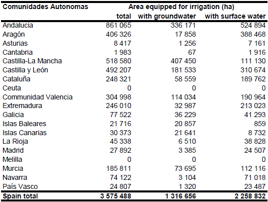
Area equipped for irrigation was 2 540 310 ha in 1990 and increased then to 2 891 050 ha in 1995, 3 478 050 ha in 2000 and 3 828 110 ha in 2003. A similar trend was observed for the area actually irrigated that was reported at 2 433 700 ha in 1990, 2 609 920 ha in 1995, 3 235 510 ha in 2000 and 3 437 370 ha in 2003 [ES01]. Sub-national statistics were derived from the Agricultural Census 1999 for the 326 municipalities [ES02]. The total area equipped for irrigation as reported by the census in 1999 was 3 575 494 ha, while the area actually irrigated was 3 315 600 ha. However, the sum of area equipped for irrigation as reported for the single municipalities, which is similar to the area incorporated in the global irrigation map, was 3 575 488 ha. The difference of 6 ha compared to the value reported at the national scale may reflect rounding errors and was thus neglected. The irrigated areas by region are shown in the Table below. The irrigated areas by region, by provinces and by municipalities can be downloaded as Spain irrigation areas in PDF or Spain irrigation areas in Excel (three sheets).
Four data sets were combined to distribute irrigated area within the municipalities. First, irrigated areas were extracted from two digital data sets covering Andalusia and the Ebro river drainage basin ([ES03], [ES04]). Polygons extracted from these data sets got the highest priority of 8 in the distribution process because both data sets are regional products associated by a lot of additional information collected at the ground (e.g. type of irrigation, water sources etc.). The second highest priority level of 7 was assigned to irrigation areas additionally extracted from irrigation maps covering entire Spain [ES05]. Priority level of 6 was assigned to areas classified as permanently irrigated land (212) or rice fields (213) in the Corine 2000 land cover database for Europe [ES06], but not present in the data sets [ES04] or [ES05]. Finally irrigated area was also assigned to 77 908 ha agricultural land classified as rainfed agriculture in the Corine database, because the area equipped for irrigation reported by the census statistics was still larger in the related 52 municipalities than the total irrigated area assigned to the irrigation schemes before.
Area actually irrigated for 60 provinces and regions was derived from the database of the Agricultural census 1999 [ES02] while area equipped for irrigation with groundwater was computed for the 19 states by using the data EU farm structure survey 2003 as described before.
References
[ES01]: Statistical Office of the European Communities (EUROSTAT). 2011. Irrigable and irrigated areas. http://epp.eurostat.ec.europa.eu/portal/ page/portal/agri_environmental_indicators/data/ database, 28/11/2011.
[ES02]: Instituto Nacional de Estadística. 2002. Censo Agrario 1999. Online data base, http://www.ine.es/inebase/index.html, 11/04/2006.
[ES03]: Consejeria de Agricultura y Pesca. 2005. Inventario y caracterización de los regadios de Andalucia. Actualización 2002. Junta de Andalucia, CD-ROM, maps online: http://www.juntadeandalucia.es/agriculturaypesca/, 15/04/2006.
[ES04]: Confederación Hidrográfica del Ebro, Oficina de Planificación Hidrológica. 2004. Superficies regadío 2000. http://www.oph.chebro.es/ContenidoCartoRegadios.htm, 08/08/2005.
[ES05]: Ministerio de Agricultura, Pesca e Alimentación. 2006. Programa de Vigilancia Ambiental del Plan Nacional de Regadios. Mapa 3 - Perímetro de los regadíos existentes. http://www.mapa.es/es/desarrollo/pags/vigilanciaambiental/mapas.htm, 06/08/2006.
[ES06]: EEA. 2005. Corine land cover 2000 - vector by country (CLC2000), version 1. http://dataservice.eea.europa.eu/dataservice/metadetails.asp?id=667, 29/08/2005.


