AQUASTAT - FAO's Global Information System on Water and Agriculture
Ethiopia
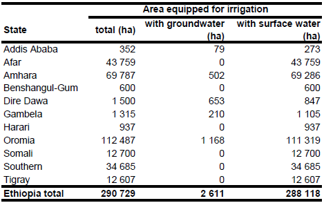
Area equipped for irrigation in year 2001 was 289 530 ha [ET01]. The figures for the district of Gambela (116 ha in year 2001) were updated by using a more recent inventory of 791 irrigation schemes [ET02] resulting in an area equipped for irrigation of 1 315 ha for this district and of 290 729 ha for Ethiopia. Total AEI in this inventory was 107 266 ha. The irrigation scheme inventory did not report spate irrigation areas which may be practised on more than 100 000 ha in Ethiopia [ET03]. This may explain the difference to the total irrigated area reported by the Ministry of Water Resources (289 530 ha) and reported in the AQUASTAT country profile [ET01]. The irrigated area per state estimated that way is visible in the table below and also can be downloaded as Ethiopia irrigation areas in PDF or Ethiopia irrigation areas in Excel.
Additionally to schemes contained in the inventory described before [ET02], irrigated areas were localized by using the FAO irrigation project database for Africa [ET04] and a map of irrigation projects available from the AQUASTAT-library [ET05]. The irrigation schemes were then digitized by using satellite imagery [ET06]. Most of the medium- and large-scale projects and some regions in which small scale irrigation is present could be detected that way. Projects with a known command area got a priority of seven and projects with an unknown command area a priority of four when assigning irrigated area to specific grid cells. The remaining irrigated area was assigned to arable land in irrigated regions as indicated on the FAO-map of irrigated areas in Africa [ET04].
Groundwater use for irrigation (mainly from springs) is practised only on a small scale in the provinces of Dire Dawa, Harari, Oromia and Amhara [ET02]. Since no data were available for Addis Ababa it was assumed that the percentage of groundwater use is similar to that one computed for Harari. Total area irrigated with groundwater computed that way was 2 611 ha. It was assumed that area actually irrigated is similar to area equipped for irrigation.
References
[ET01]: FAO. 2005. AQUASTAT country profile Ethiopia. Table 6. FAO, Rome, http://www.fao.org/ag/agl/aglw/aquastat/countries/index.stm, 11/11/2005.
[ET02]: Awulachew, S. B., Yilma, A. D., Loulseged, M., Loiskandl, W., Ayana, M., Alamirew, T. 2007. Water Resources and Irrigation Development in Ethiopia. International Water Management Institute, Working Paper 123, Colombo, Sri Lanka, 78pp.
[ET03]: Government of Ethiopia. 2008. National investment brief Ethiopia. High-level conference on water for agriculture and energy in Africa: the challenges of climate change, Sirte, Libyan Arab Jamahiriya, December 15-17, 2008, http://www.sirtewaterandenergy.org/, 18/08/2009.
[ET04]: FAO. 1987 (updated in 2005). Irrigated areas in Africa. FAO, Rome, Italy.
[ET05]: Unknown. Ethiopia – irrigation projects, dams and rivers. Map available in the AQUASTAT-library.
[ET06]: Earth Satellite Corporation. 2004. Landsat GeoCover (2000/ETM+) Edition Mosaics, tiles 071-266, 071-267, 071-268, 071-281, 071-282, 071-283, 071-293, 071-294, 071-295. Sioux Falls, USA, USGS (available at http://glcfapp.umiacs.umd.edu:8080/esdi/index.jsp).


