AQUASTAT - FAO's Global Information System on Water and Agriculture
Georgia
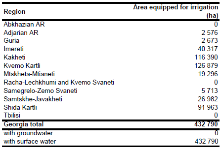
In the Soviet period, infrastructure was built to irrigate 469 000 ha of agricultural land, mainly located in the more arid east of the country [GE01]. In the 1990s, civil strife, war, vandalism and theft, as well as problems associated with land reform, the transition to a market economy, and the loss of markets with traditional trading partners, contributed to a significant reduction in the irrigated area. It has been reported that only about 160 000 ha were irrigated during the severe drought in 2000. Almost all pumping schemes (about 143 000 ha) were out of order. Therefore, a rehabilitation programme was started by Georgia's State Department of Amelioration and Water Economy to renew the infrastructure of existing irrigation and drainage schemes and to establish amelioration service cooperatives. About 255 000 ha were covered by this programme [GE02]. Total area equipped for irrigation in year 2007 was 432 790 ha, consisting of 31 500 ha equipped wetland and inland valley bottoms and 401 290 ha full or partial control irrigation [GE01]. AEI in full or partial control irrigation for 11 regions was derived from the Aquastat country questionnaire. No data have been available on the location of equipped wetland and inland valley bottoms. Therefore total AEI was estimated for each region by scaling AEI in full or partial control schemes (401 290 ha) to 432 790 ha. The irrigated area per region estimated that way is visible in the table below and also can be downloaded as Georgia irrigation areas in PDF or Georgia irrigation areas in Excel.
Irrigated areas and main zones of irrigation development were digitized from an irrigation map published in a project report [GE02] and from a map showing irrigated areas in the Caucasus region [GE03]. Irrigated area was then assigned to all pixels classified in the Globcover 2009 landcover data set [GE04] as “Rainfed croplands”, “Mosaic cropland (50-70 percent) / vegetation (grassland/shrubland/forest) (20-50 percent)”, or “Mosaic vegetation (grassland/shrubland/forest) (50-70 percent) / cropland (20-50 percent)” and located within the digitized irrigation zones.
Irrigation is completely based on surface water resources (river diversion), groundwater is not used for irrigation in Georgia [GE01]. In year 2006 only 126 060 ha (31.4 percent) of the area equipped for irrigation in full/partial control irrigation schemes was irrigated. Based on this fraction, total area actually irrigated was estimated therefore at 135 955 ha.
References
[GE01]: FAO. 2011. AQUASTAT country profile of Georgia, version 2008. FAO, Rome, Italy.
[GE02]: World Bank. 2001. Irrigation and drainage community development project. Project appraisal document. Report No. 22042-GE, http://www.worldbank.org, 18/10/2004.
[GE03]: Achtnich, W. 1980. Bewässerungslandbau, p. 36. Stuttgart, Germany, Ulmer.
[GE04]: European Space Agency. 2010. GlobCover 2009 (Global Land Cover Map). http://due.esrin.esa.int/globcover/, 07/09/2012.


