AQUASTAT - FAO's Global Information System on Water and Agriculture
Guinea
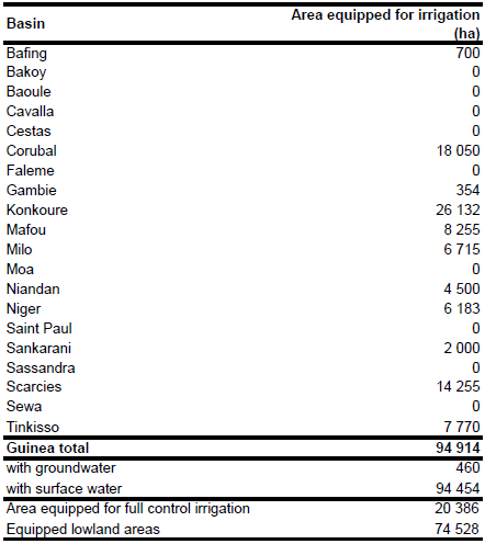
Area equipped for irrigation and area actually irrigated is 20 386 ha in full/partial control schemes, 74 528 ha in equipped wetlands and thus 94 914 ha in total [GN01]. The figures refer to year 2001. The irrigated area per basin is visible in the table below and also can be downloaded as Guinea irrigation areas in PDF or Guinea irrigation areas in Excel.
The location and command area for 13 irrigation schemes was derived from the FAO-map of irrigated areas in Africa [GN02]. The total irrigated area in these schemes is summing up to 6 870 ha. The remaining irrigated area was distributed according to the GLC2000 land cover map for Africa [GN03] to areas classified as "Mangrove", "Irrigated cropland", "Mosaic of cropland and woody vegetation" or "Mosaic of forest and cropland". First it was made sure that 50 850 ha irrigated area was assigned to areas classified as "Mangrove" (see [GN01]). After area equipped for irrigation was assigned also to the other land cover types beginning with "Irrigated cropland", then "Mosaic of cropland and woody vegetation" and finally if necessary also to areas classified as "Mosaic of forest and cropland" with the lowest priority.
2.3 percent (460 ha) of the area equipped for irrigation in full/partial control schemes is irrigated with groundwater while the remaining part is irrigated with water from surface water sources [GN01].
References
[GN01]: FAO. 2005. AQUASTAT country profile Guinea, FAO, Rome, Italy.
[GN02]: FAO. 1987 (updated in 2005). Irrigated areas in Africa. FAO, Rome, Italy.
[GN03]: Mayaux, P., Bartholomé, E., Cabral, A., Cherlet, M., Defourny, P., Di Gregorio, A., Diallo, O., Massart, M., Nonguierma, A., Pekel, J.-F., Pretorius, C., Vancutsem, C., and Vasconcelos, M. 2003. The Land Cover Map for Africa in the Year 2000. European Commision Joint Research Centre, available at: http://www-gem.jrc.it/glc2000).


