AQUASTAT - FAO's Global Information System on Water and Agriculture
Greece
The area reported to be irrigable increased in Greece from 1 130 570 ha in 1990 to 1 235 300 ha in 1995 and 1 521 600 ha in 2003. The area actually irrigated also increased from 932 980 ha in 1990 to 1 142 180 ha in 1995 and 1 294 400 ha in 2003 [GR01]. Area equipped for irrigation was computed by selecting the maximum of the irrigable area as reported by the EUROSTAT for 13 regions and for the years 1997, 2000 and 2003 [GR01]. The island of Crete was further subdivided in four districts because irrigation statistics could be obtained from the literature [GR02]. Area equipped for irrigation by region computed that way adds up to 1 544 530 ha. This area is visible in the table below and also can be downloaded as Greece irrigation areas in PDF or Greece irrigation areas in Excel.
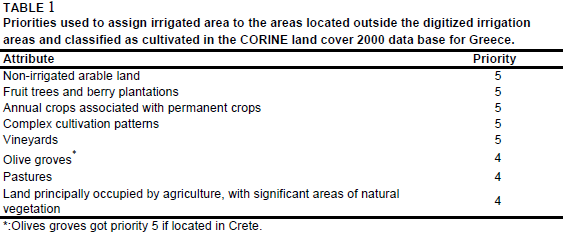
Irrigated area was assigned first to all areas classified as "Permanently irrigated land" (212) or "Rice fields" (213) by the Corine 2000 land cover database for Europe [GR03]. 658 386 ha were distributed in total that way. Additionally other irrigation areas were digitized from an irrigation map [GR04] or from a land use map published in an atlas [GR05]. Cultivated land located within the digitized polygons was extracted from the Corine land cover data base and 432 250 ha of irrigated land were assigned to these areas. Finally, the remaining fraction of the area equipped for irrigation was assigned to cultivated land located outside the digitized polygons by using the priorities shown in Table 1. In this process it was assumed that the irrigation density in polygons of priority 4 is only 10 percent of the irrigation density in polygons of priority 5. Polygons of priority 4 represent pastures, marginal areas and olive groves and thus areas that are usually not irrigated in Greece. An exception was made for the island of Crete. It was reported that more than 40 percent of the olive groves are irrigated there today [GR06]. Therefore polygons classified as olive groves and located on Crete got the higher priority level 5.
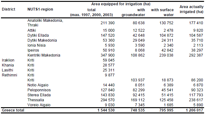
Area equipped for irrigation with groundwater was computed based on the data collected by the EU farm structure survey 2003 as described before. Area actually irrigated per province was computed as average of AAI reported by the farm structure surveys 1997, 2000, and 2003 [GR01]. Total AAI computed that way was summing up to 1 206 017 ha.
References
[GR01]: Statistical Office of the European Communities (EUROSTAT). 2011. Irrigable and irrigated areas. http://epp.eurostat.ec.europa.eu/portal/ page/portal/agri_environmental_indicators/data/ database, 28/11/2011.
[GR02]: Katsikides, S., Warnat, H. & Dörflinger, G. 2004. Detailed empirical analysis of the present socio-economic structure under the aspect of water usage. Report within the MEDIS project, 163 pp., http://www.uni-muenster.de/Umweltforschung/medis/, 27/07/2006.
[GR03]: EEA. 2005. Corine land cover 2000 - vector by country (CLC2000), version 1. http://dataservice.eea.europa.eu/dataservice/metadetails.asp?id=667, 29/08/2005.
[GR04]: Sauerwein, F. 1993. Der Bewässerungsfeldbau in Griechenland - Entwicklung, Formen und Probleme. In H. Popp & K. Rother, eds. Die Bewässerungsgebiete im Mittelmeerraum, Passau, Germany, Passavia Universitätsverlag, 113-116.
[GR05]: Schulze, H. (ed.) 1998. Alexander Weltatlas. Ernst Klett Schulbuchverlag, Stuttgart, Germany, 225 pp.
[GR06]: Institute of Olive Tree and Subtropical Plants. 2003. General Info. Report available on the web-page of the National Agricultural Research Foundation (NAGREF), http://www.nagref-cha.gr/endocs/general.html, 27/07/2006.


