AQUASTAT - FAO's Global Information System on Water and Agriculture
Grenada
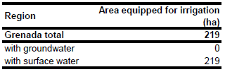
In the whole of Grenada 219 ha are equipped for irrigation. The figure refers to 1997 [GD01]. For Grenada no information could be found on irrigated areas on sub-national level. The irrigated area is visible in the table below and also can be downloaded as Grenada irrigation areas in PDF or Grenada irrigation areas in Excel.
The irrigated area within the country was distributed to cropping areas as indicated on the USGS land cover characterization map [GD02].
All irrigation in Grenada is assumed to be based on surface water, 1 percent from river diversion, 6.5 percent from reservoirs and the remainder from direct pumping from rivers [GD01]. It was assumed that area actually irrigated is similar to area equipped for irrigation reported for year 1997 [GD01].
References
[GD01]: FAO. 2000. AQUASTAT country profile of Grenada. FAO, Rome, Italy.
[GD02]: USGS. 2001. Global Land Cover Characterization, map version 2, http://edcdaac.usgs.gov/ index.html, 06/10/2010.


