AQUASTAT - FAO's Global Information System on Water and Agriculture
Guatemala
The total area equipped for irrigation in Guatemala increased from 129 803 ha [GT01] in year 1997 to 142 499 ha in year 2004 [GT02]. To assign area equipped for irrigation to departments, data were used from the Support Program for the Reconversion of Food and Agriculture Production (PARPA) as cited in [GT02].
The distribution of irrigated areas within the departments is mainly based on a World Bank study on private irrigation from the year 1993 [GT03] and on a national map showing the location of irrigation projects in 1967 [GT04]. Apart from this two other national sources were used with information on the location but without the extent of the areas under irrigation [GT05], [GT06]. The remaining area equipped for irrigation was equally distributed over area classified as “Agro-productive system” in the Central American Ecosystems Map [GT07]. The irrigated area per department estimated that way is visible in the table below and also can be downloaded as Guatemala irrigation areas in PDF or Guatemala irrigation areas in Excel.
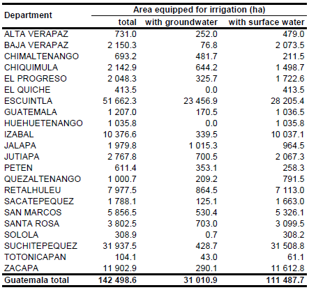
Area equipped for irrigation with groundwater was 31 011 ha in year 2004 [GT02]. It was assumed that all area equipped for irrigation is actually being used [GT01].
References
[GT01]: FAO. 2000. AQUASTAT country profile of Guatemala. FAO, Rome, Italy.
[GT02]: Ballestero, M., Reyes, V., & Astorga, Y. 2007. Groundwater in Central America: its importance, development and use, with particular reference to its role in irrigated agriculture. In: Giordano, M. & Villholth, K. G., The agricultural groundwater revolution. Opportunities and threads to development. International water Management Institute (IWMI), Colombo, Sri Lanka, 100-128, http://www.iwmi.cgiar.org/Publications/CABI\_Publications/index.aspx, 12/08/2009.
[GT03]: World Bank. 1993. Central America - Subsector Study on private Irrigation. Vol.2.
[GT04]: Ministerio de Agricultura. 1967. Programa Nacional de Pequeno Riego, Anexo II-12.
[GT05]: Instituto Geografico Nacional. 1982. Mapa de cobertura y uso actual de la tierra, cultivos y pastos bajo riego.
[GT06]: Ministerio de Agricultura. 1974. Operacion Conservacion y Tecnificacion de Distritos de Riego. Vol. 1, Anexo 3.
[GT07]: World Bank and CCAD. 2001. Ecosystems of Central America (ArcView regional map files at 1:250,000). World Bank, Comisión Centroamericana de Ambiente y Desarrollo (CCAD), World Institute for Conservation and Environment (WICE), and the Centro Agronómico Tropical de Investigación y Enseñanza (CATIE), Washington, D.C., http://www.birdlist.org/ cam/themes/map_download_page.htm, 15/11/2010.


