AQUASTAT - FAO's Global Information System on Water and Agriculture
Guyana
The total area equipped for irrigation in Guyana equals 150 134 ha [GY01]. The figures per region originate from the AQUASTAT-library and refer to 1991. The irrigated area is concentrated in the northern provinces of the country along the coast line.
The irrigated area within the regions was distributed based on an irrigation map published as part of a World Bank study in 1992 [GY02]. The irrigated area per region estimated that way is visible in the table below and also can be downloaded as Guyana irrigation areas in PDF or Guyana irrigation areas in Excel.
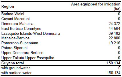
Irrigation water supply in Guyana is from reservoirs (so called conservancies) using a network of main and secondary canals or from rivers through pumping. In contrast, domestic water supply in the coastal area is mainly depending on groundwater [GY01]. Based on this information it was assumed that all irrigation is from surface water.
References
[GY01]: FAO. 2000. AQUASTAT country profile of Guyana. FAO, Rome, Italy.
[GY02]: World Bank. 1992. Guyana Agricultural Sector Review. Report No. 10410-GUA, World Bank, Washington, USA.


