AQUASTAT - FAO's Global Information System on Water and Agriculture
Haiti
The total area equipped for irrigation in Haiti equals 91 502 ha while area actually irrigated is 65 469 ha [HT01]. The figures per department originate from the AQUASTAT-library and refer to 1991.
The irrigated area within the departments was distributed based on a map showing the outlines of 84 irrigated areas in 1972 [HT02]. The irrigated area per department estimated that way is visible in the table below and also can be downloaded as Haiti irrigation areas in PDF or Haiti irrigation areas in Excel.
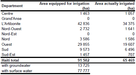
Very little information has been available related to sources of irrigation water in Haiti. The largest irrigation scheme in the country (35 411 ha area equipped for irrigation, 39 percent of total irrigation area in Haiti) is located in the Artibonite valley and uses water from the Artibonite River [HT01]. Also, it was reported, that total groundwater resources of the country account for 17% of the total water resources. Based on this information percentage of irrigated area from groundwater sources was estimated at 15 percent.
References
[HT01]: FAO. 2000. AQUASTAT country profile of Haiti. FAO, Rome, Italy.
[HT02]: Organisation des Etats Americans. 1972. Mission d'Assistance Technique Integree, Cartes, map: Donnees Hydrologiques et Utilisation des Eaux.


