AQUASTAT - FAO's Global Information System on Water and Agriculture
Indonesia
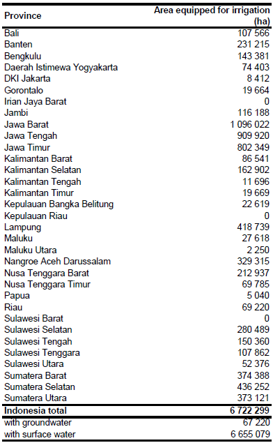
Area equipped for irrigation was 6 722 299 ha in year 2005 [ID01]. Following the categorization used by FAO, only technical, semi-technical, and simple irrigation schemes where considered. In addition to areas equipped for irrigation, non-equipped cultivated wetlands of Indonesia covered 3 133 317 ha, of which 2 088 622 ha were village managed and 1 044 695 cultivated by the state [ID02]. The statistics indicate a strong increase in areas equipped for irrigation during the last decade. About 46 percent of the irrigated area is located on the island of Java and about 34 percent on the island of Sumatra, respectively. The irrigated area per province estimated that way is visible in the table below and also can be downloaded as Indonesia irrigation areas in PDF or Indonesia irrigation areas in Excel.
Irrigated areas were digitized from maps provided by the General Directorate of Water Resources [ID03]. About 28 percent of the AEI were assigned to irrigated areas shown on these irrigation maps. In addition, irrigated land was assigned to pixels classified as irrigated crops in a land cover classification based on the Globecover data set [ID04]. When the sum of irrigated area assigned to specific pixels was still smaller than the AEI reported by the statistics, the remaining irrigated land was assigned to pixels classified in [ID04] as rainfed crops.
Irrigation from groundwater covered an area of 1 percent of total AEI or about 67 220 ha [ID02]. Subnational data on the share of groundwater irrigation or on the AEI actually irrigated were not available. However, the harvested area of irrigated crops was 13 388 358 ha in year 2005 [ID02], indicating a very high cropping intensity on irrigated land. It was therefore assumed, that the total AEI was actually irrigated in year 2005.
References
[ID01]: Ministry of Public Works. 2006. Rekapitulasi Daerah Irigasi Tahun 2005. Ministry of Public Works of Indonesia, http://www.pu.go.id/publik/ind/produk/info\_statistik/\_index.asp, 19/08/2009.
[ID02]: FAO. 2012. AQUASTAT country profile of Indonesia, version 2010. FAO, Rome, Italy.
[ID03]: Directorat Jenderal Sumber Daya Air. 2012. Daerah Irigasi. http://sda.pu.go.id/geo/, 22/11/2012.
[ID04]: FAO. 2009. Land cover of Indonesia. FAO, Rome, Italy, http://www.fao.org/geonetwork/srv/en/main.home?uuid=f3f61bb2-78bf-4aba-a5ba-e708183336ec, 13/07/2011.


