AQUASTAT - FAO's Global Information System on Water and Agriculture
Ireland
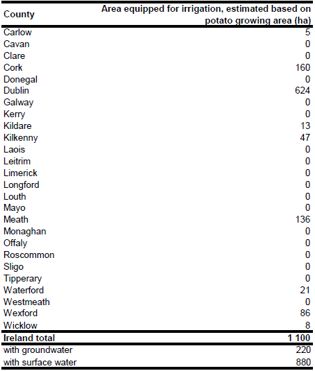
The irrigated area in Ireland is about 1 100 ha and consists of about 500 ha early potatoes, 500 ha vegetables and 100 ha strawberries in plastic tunnels. Most of the irrigated area is located in the southern, eastern and south-eastern regions of the country [IE01]. No sub-national statistics on irrigated area have been available for Ireland. Therefore the potato growing area of the counties located in the south, east or south-east was extracted from the Agricultural Census 2000 [IE02] and it was assumed that the irrigated area is proportional to the potato growing area (in total 2 122 ha). The irrigated area per county estimated that way is visible in the table below and also can be downloaded as Ireland irrigation areas in PDF or Ireland irrigation areas in Excel.
Area equipped for irrigation was equally distributed over all polygons classified as non-irrigated arable land (211) or complex cultivation patterns (242) in the Corine 2000 land cover database for Europe [IE03].
Statistics related to irrigated areas and sources of irrigation water were not available. Based on data for neighbouring West England and Wales, percentage of irrigated area from groundwater sources was estimated at 20 percent.
References
[IE01]: Baldock, D., Caraveli, H., Dwyer, J., Einschütz, S., Petersen, J.E., Sumpsi-Vinas, J. & Varela-Ortega, C. 2000. The environmental impacts of irrigation in the European Union. A report to the Environment Directorate of the European Commission, 147 pp., http://ec.europa.eu/environment/agriculture/, 07/07/2006.
[IE02]: Central Statistics Office Ireland. 2002. Census of Agriculture Main Results, June 2000. Dublin, Ireland, 96 pp., http://www.cso.ie/releasespublications/pr\_agrifishpubshardcopies.htm, 31/07/2006.
[IE03]: EEA. 2005. Corine land cover 2000 - vector by country (CLC2000), version 1. http://dataservice.eea.europa.eu/dataservice/metadetails.asp?id=667, 29/08/2005.


