AQUASTAT - FAO's Global Information System on Water and Agriculture
Iraq
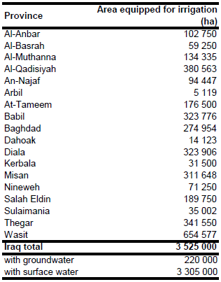
Area equipped for irrigation is reported to be 3 525 000 ha [IQ01]. The figures refer to 1990. A large part of this area is not irrigated. Because of waterlogging and salinity, the area irrigated in 1993 was about 1 936 000 ha [IQ02] and this had decreased to 1 775 750 ha in 2001 [IQ03] and varied between 2.1 Million ha and 2.6 Million ha in period 2004 to 2009 [IQ04]. However, the three Kurdish provinces in the north of the country (Dahoak, Arbil and Sulaimania) are not included in these figures. Therefore, statistics originating from a land survey in 1992 and provided by the Kurdistan Democratic Party [IQ05] were used for these provinces. Statistics on the area equipped for irrigation were not available on a province level. Therefore, it was estimated by combining areas computed from digitized land-use maps [IQ06], tactical pilot charts [IQ07] and satellite imagery [IQ08] with province-level statistics of the area actually irrigated in 1993 [IQ02] and 2001 [IQ03]. It was assumed that the area equipped for irrigation was as least as high as the maximum of the area actually irrigated in 1993 and 2001. In order to estimate the area of the irrigated areas not in use, the land-use maps, pilot charts and satellite imagery were used for the downstream provinces of Muthannia, Qadisiya, Najaf, Babil, Baghdad, Thegar, Diala, Misan and Wasit. The estimates for the northern provinces of Dahoak, Arbil and Sulaimania are as reported in the land survey. The irrigated area per province estimated that way is visible in the table below and also can be downloaded as Iraq irrigation areas in PDF or Iraq irrigation areas in Excel.
Irrigated areas were digitized from land-use maps [IQ06], tactical pilot charts [IQ07] and satellite imagery [IQ08].
Area equipped for irrigation with groundwater was 220 000 ha or 6.2 percent of total AEI in year 1990 and 146 000 ha in year 1997 [IQ01]. Area actually irrigated was set to 2 530 000 ha representing the annual mean reported in [IQ04] for the period 2004-2009. Subnational information on area actually irrigated or area equipped for irrigation with groundwater was not available.
References
[IQ01]: FAO. 2012. AQUASTAT country profile of Iraq, version 2008. FAO, Rome, Italy.
[IQ02]: Arab Organization for Agricultural Development. 1994. Arab Agricultural Statistics Yearbook. Volume No. 14, Table 18. Khartoum.
[IQ03]: Arab Organization for Agricultural Development. 2003. Arab Agricultural Statistics Yearbook 2002. Agricultural Information, Documentation and Statistics Center, http://www.aoad.org, 19/07/2004.
[IQ04]: Arab Organization for Agricultural Development. 2006-2010. Arab Agricultural Statistics Yearbook, Volumes 26-30. Arab Organization for Agricultural Development AOAD, Khartoum, http://www.aoad.org/AASYXX.htm, 30/11/2012.
[IQ04]: Kurdistan Democratic Party. 2004. Agriculture in Kurdistan, http://www.kdp-ankara.org.tr, 19/07/2004.
[IQ05]: Universität Tübingen. 1993. Tübinger Atlas des Vorderen Orients, Plate AX04. Tübingen, Germany.
[IQ06]: Humanitarian Information Centre for Iraq. 2004. Tactical pilotage charts at the 1:500.000, http://www.hiciraq.org, 19/07/2004.
[IQ07]: Earth Satellite Corporation. 2004. Landsat GeoCover (2000/ETM+) Edition Mosaics, Tiles 071-287, 071-288, 071-298, 071-299, 071-300, 071-310 and 071-311. Sioux Falls, USA, USGS, http://glcfapp.umiacs.umd.edu:8080.


