AQUASTAT - FAO's Global Information System on Water and Agriculture
Japan
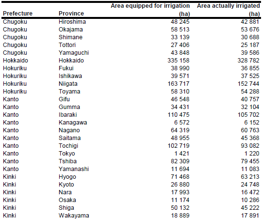
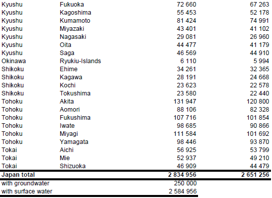
Area equipped for irrigation was 3 128 079 ha in year 1993, comprising of 2 781 411 ha irrigated paddy fields and 346 668 ha irrigated upland fields [JP01]. Almost all paddy fields are equipped for irrigation. In contrast, irrigation of non-paddy fields (upland crops) started after World War II and extended to about 10 percent irrigated upland fields at the beginning 1990s [JP02]. Area equipped for irrigation per prefecture was estimated as the sum of paddy field area reported for year 2010 [JP03] and irrigated area of upland crops which was computed based on the percentage of irrigated upland area reported for each province in year 1993 [JP04] and the total growing area of upland crops in year 2010 [JP03]. Total area equipped for irrigation estimated this way was 2 834 956 ha. The irrigated area per province is visible in the table below and also can be downloaded as Japan irrigation areas in PDF or Japan irrigation areas in Excel.The declining trend in AEI (compared to the data reported for year 1993) has been caused mainly by the reduction in the extent of paddy land to 2 496 000 ha in year 2010 [JP03].
The irrigated areas were digitized from an irrigation map sent to FAO with the AQUASTAT country questionnaire [JP05].
The area equipped for irrigation is in general irrigated with surface water withdrawn from reservoirs and streams. In addition, groundwater is used supplementary on about 500 000 ha during the low water season from April to September, especially in August [JP01]. To account for the area irrigated with a mix of both, surface water and groundwater, area irrigated with groundwater was set to 250 000 ha and the remaining area was assumed to be irrigated with surface water. Area actually irrigated per prefecture was computed as the difference between the area equipped for irrigation and the extent of unplanted paddy land reported for year 2010 [JP06]. Total area actually irrigated estimated this way was 2 651 256 ha. This should be considered as the maximum extent because more than 27 percent of the paddy land was cropped in year 2010 with non-rice crops (e.g. vegetables) [JP06] and it maybe that a fraction of these crops was cultivated as rainfed crops.
References
[JP01]: FAO. 2013. AQUASTAT country profile of Japan, version 1997. FAO, Rome, Italy.
[JP02]: Japanese Society of Irrigation, Drainage and Reclamation Engineering. 1995. Irrigation and drainage in Japan. Third Edition. Tokyo.
[JP03]: Statistics Bureau. 2011. Japan statistical yearbook 2011. Ministry of Internal Affairs and Communications, Statistics Bureau, http://www.stat.go.jp/english/data/nenkan/index.htm, 04/02/2013.
[JP04]: Ministry of Agriculture, Forestry and Fisheries. 1994. Status of agricultural land use in Japan. Agricultural Structure Improvement Bureau (available in the AQUASTAT library).
[JP05]: Unknown. 1997. Irrigation in Japan. Map sent to FAO with the AQUASTAT country questionnaire.
[JP06]: Ministry of Agriculture, Forestry and Fisheries. 2012. The 86th statistical yearbook of Ministry of Agriculture, Forestry and Fisheries (2010~2011). Ministry of Agriculture, Forestry and Fisheries, http://www.maff.go.jp/e/tokei/kikaku/nenji\_e/86nenji/index.html, 04/02/2013.


