AQUASTAT - FAO's Global Information System on Water and Agriculture
Kazakhstan
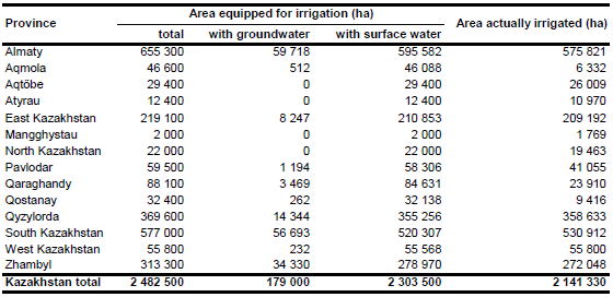
Total area equipped for irrigation in year 1993 was 3 556 400 ha and consisted of 2 313 100 ha full or partial control irrigation, 138 700 ha equipped wetlands and inland valley bottoms and 1 104 600 ha spate irrigation area [KZ01]. However, it has been estimated that about 680 000 ha of the land were out of use in the 1994 cropping season because of soil salinization, waterlogging, broken or incomplete distribution systems or because of other reasons [KZ02]. The irrigated areas in 2002 consisted of 1 220 000 ha of full or partial control irrigation and 580 600 ha of so-called "engineering-liman irrigation and inundated hay lands" [KZ03] representing spate irrigation areas and equipped wetlands and inland valley bottoms. Area equipped for irrigation per province in year 2006 was estimated by selecting for each province the maximum of the irrigated areas reported in the statistical yearbook “Environmental protection and sustainable development in Kazakhstan 2010” [KZ04] and the report of the agricultural census 2006/2007 [KZ05]. The extent of irrigated land in the western part of Kazakhstan, where mainly spate irrigation is practised, was larger in the yearbook [KZ04] while irrigated areas in the southern part, where most of the full or partial control irrigation schemes are located, was larger in the agricultural census report [KZ05]. Total area equipped for irrigation estimated this way was 2 482 500 ha. The irrigated area per province is visible in the table below and also can be downloaded as Kazakhstan irrigation areas in PDF or Kazakhstan irrigation areas in Excel.
The irrigated areas were localized using a map of irrigation projects [KZ02] and two course-scale maps showing the outlines of the major irrigated areas of the country ([KZ06]; [KZ07]). By using Landsat satellite imagery [KZ08] and a map of irrigation areas in the Aral Sea Basin [KZ09], the outlines of the irrigated areas were then digitized in more detail. These digitized irrigated areas were combined with irrigated cropland derived from the Globcover regional classification for Central Asia [KZ10]. Irrigated area was then assigned with the highest priority to pixels being irrigated according to both data sources and after that, if required, to pixels that were either covered by the digitized irrigated areas or classified as irrigated by Globcover.
Area actually irrigated was estimated for each province based on the ratio between irrigated arable land (1 392 100 ha in total) and arable land equipped for irrigation (1 573 600 ha in total) reported by the agricultural census 2006/2007 for the full or partial control irrigation schemes [KZ05]. Total area actually irrigated computed this way was 2 141 300 ha. The difference between AEI and AAI (341 200 ha) is in good agreement with the so called “reserve land” reported by the statistical yearbook [KZ04] for year 2006 (368 400 ha). Area equipped for irrigation with groundwater was 179 000 ha in year 1993 [KZ01]. It was assumed that this infrastructure is still operational. Area equipped for irrigation with groundwater was assigned to each province relative to the share on equipped arable land reported by the agricultural census 2006/2007 [KZ05].
References
[KZ01]: FAO. 2013. AQUASTAT country profile of Kazakhstan, version 1998. FAO, Rome, Italy.
[KZ02]: World Bank. 1996. Kazakhstan, irrigation and drainage improvement project. Staff appraisal report. Report No. 15379-KZ. Washington, DC.
[KZ03]: UNDP. 2004. Water resources of Kazakhstan in the new Millennium 2004. United Nations Development Programme (UNDP), Almaty, Kazakhstan, http://www.undp.kz/ library_of_publications/start.html?redir=center_view&id=2496, 20/08/2009.
[KZ04]: Agency of Statistics of the Republic of Kazakstan. 2010. Environmental protection and sustainable development in Kazakhstan 2010. Agency of Statistics of the Republic of Kazakstan, Astana, Kazakhstan, http://www.kaz.stat.kz/PUBLISHING/Pages/ Statistical_collection.aspx, 15/02/2013.
[KZ05]: Agency of Statistics of the Republic of Kazakstan. 2008. Report of the National Agricultural Census 2006/2007. Volume 1, part 2, in Russian. Agency of Statistics of the Republic of Kazakstan, Astana, Kazakhstan, http://www.eng.stat.kz/cx\_perepis/ sborniki/Pages/default.aspx, 15/02/2013.
[KZ06]: UNEP. 2004. Environment State of the Aral Sea Basin. http://www.grida.no, 12/09/2004.
[KZ07]: Achtnich, W. 1980. Bewässerungslandbau, Stuttgart, Germany, Ulmer.
[KZ08]: Earth Satellite Corporation. 2004. Landsat GeoCover (2000/ETM+) Edition Mosaics, tiles 071-302, 071-313, 071-314, 071-315, 071-323, 071-324, 071-325, 071-336, 071-337, 071-345, 071-346, 071-347, 071-348, 071-361, 071-362, 071-363, 071-364, 071-373, 071-374, 071-375, 071-386 and 071-387. Sioux Falls, USA, USGS, http://glcfapp.umiacs.umd.edu:8080.
[KZ09]: Unknown. Aral Sea Basin 1:2,500 000 - administrative boundaries and irrigated areas. Map available in the FAO-AGL library.
[KZ10]: ESA. 2008. Regional Globcover Land Cover – Central Asia. Version 2.2. http://postel.mediasfrance.org/en/DOWNLOAD/, 24/03/2009.


