AQUASTAT - FAO's Global Information System on Water and Agriculture
Kyrgyzstan
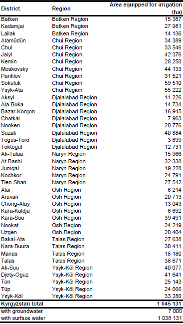
Area equipped for irrigation for the seven regions (1 045 131 ha in total) was derived from a melioration inventory related to year 2005 [KG01]. To estimate area equipped for irrigation for each of the 40 districts an inventory for year 1994 was used [KG02]. AEI reported in this inventory for each district (1 075 040 ha in total) was scaled so that the sum of AEI in each region was similar to the AEI reported in [KG01] for year 2005. The irrigated area per district estimated that way is visible in the table below and also can be downloaded as Kyrgyzstan irrigation areas in PDF or Kyrgyzstan irrigation areas in Excel.
The irrigated areas were localized using a map of irrigation projects [KG03] and then digitized using satellite imagery [KG04] and a map of irrigated areas in the Aral Sea Basin [KG05]. These digitized irrigated areas were combined with irrigated cropland derived from the Globcover regional classification for Central Asia [KG06]. Irrigated area was then assigned with the highest priority to pixels being irrigated according to both data sources and after that, if required, to pixels that were either covered by the digitized irrigated areas or classified as irrigated by Globcover.
Area equipped for irrigation with groundwater was 7 000 ha in year 1994 [KG06] while area actually irrigated was 1 021 400 ha in year 2005 [KG07].
References
[KG01]: Department of Water Resources. 2005. Melioration Sector's Summary Information of Water Resources Department on 01.09.2005. Report sent to FAO as part of the country questionnaire 2009.
[KG02]: Asian Development Bank. 1995. Agriculture sector program loan to the government of the Kyrgyz Republic. Project Preparation Technical Assistance, Annex 4 - Irrigation, report prepared by S. Gardiner, ULG Consultants Ltd, available in the AQUASTAT library.
[KG03]: World Bank. 1998. Kyrgyz Republic - Irrigation Rehabilitation Project. Project appraisal document. Report No. 17531 KG.
[KG04]: Earth Satellite Corporation. 2004. Landsat GeoCover (2000/ETM+) Edition Mosaics, tiles 071-344, 071-345, 071-360, 071-361 and 071-373. Sioux Falls, USA, USGS, http://glcfapp.umiacs.umd.edu:8080.
[KG05]: Unknown. Aral Sea Basin 1:2,500 000 - administrative boundaries and irrigated areas. Map available in the FAO-AGL library.
[KG06]: ESA. 2008. Regional Globcover Land Cover – Central Asia. Version 2.2. http://postel.mediasfrance.org/en/DOWNLOAD/, 24/03/2009.
[KG07]: FAO. 2013. AQUASTAT Country Statistics.


