AQUASTAT - FAO's Global Information System on Water and Agriculture
Lao People's Democratic Republic
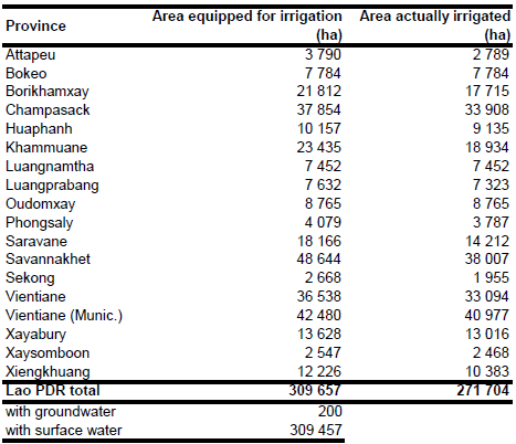
Area equipped for irrigation was reported at 310 000 ha [LA01]. The figures refer to year 2005. Areas equipped for irrigation and area actually irrigated per province were derived from an inventory reporting areas equipped for irrigation by weirs, reservoirs, pump schemes, temporary weirs, gabions, gates and dikes and area actually irrigated in the wet and dry season [LA02]. Area actually irrigated was set to the average of the areas irrigated in the wet season in the period 2001-2005 (271 704 ha in total). Area equipped for irrigation was set to the area irrigated in the wet season 2002, with the exception of the provinces Bokeo, Luangnamtha and Oudomxay, where the AAI computed as the average of the years 2001-2005 was larger than the AAI in year 2002. For these provinces AEI was assumed to be similar to AAI. Total AEI computed that way summed up to 309 657 ha and it is visible in the table below and also can be downloaded as Lao People's Democratic Republic irrigation areas in PDF or Lao People's Democratic Republic irrigation areas in Excel.
Digital maps of irrigated areas (polygon dataset) and irrigation projects (point dataset) were used as compiled by the Mekong River Commission [LA03]. In general, the point dataset was used for small schemes (fewer than 300 ha) while the polygon dataset was used for large schemes (more than 300 ha) - 265 000 ha of irrigated area was located in this way. The remaining part of the irrigated area was distributed to paddy areas taken from a digital landcover map [LA04].
Area equipped for irrigation with groundwater is 200 ha [LA05].
References
[LA01]: Pheddara, P. 2007. Large rice-based irrigation systems in Lao PDR. In: Proceedings of the regional workshop on the future of large rice-based irrigation systems in Southeast Asia held in Ho Chi Minh City, Viet Nam, October 26-28, 2005. RAP Publication 2007/28, FAO, Rome, Italy, 101-107, http://www.fao.org/docrep/010/ai408e/ai408e00.htm, 18/08/2009.
[LA02]: FAO. 2008. Lao PDR. Agricultural Statistics 30 years (1976-2006). Regional data exchange systems (RDES) on Food and Agricultural Statistics in Asia and the Pacific. http://www.faorap-apcas.org/lao.html, 03/12/2008.
[LA03]: Mekong River Commission Secretariat. 2003. People and the environment atlas of the Lower Mekong Basin. CD-ROM. Phnom Penh.
[LA04]: FAO. 2004. Dataset Landcover.zip, provided by FAO ASIACOVER project.
[LA05]: FAO. 2012. AQUASTAT country profile of Lao People´s Democratic Republic, version 2010. FAO, Rome, Italy.


