AQUASTAT - FAO's Global Information System on Water and Agriculture
Lebanon
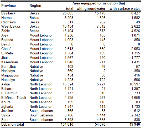
Area equipped for irrigation per district was derived from the Agricultural Atlas of Lebanon, that is based on the results of an agricultural census undertaken in year 1998 [LB01]. Total AEI according to this inventory was 104 009 ha as shown in the table below and also can be downloaded as Lebanon irrigation areas in PDF or Lebanon irrigation areas in Excel.
Irrigated areas were digitized from a land-use map [LB02] and from satellite imagery [LB03]. In several districts, the extent of the areas digitized that way was smaller than the AEI reported by the statistics. Therefore, the remaining AEI was assigned in these districts to areas classified in the regional Globcover landcover classification for North Africa [LB04] as rainfed cropland and, if required, to areas classified as mosaics of rainfed cropland with other land uses. The resulting pattern of irrigated land was quite similar to a map showing irrigation schemes in Lebanon in year 2004 [LB05].
Area irrigated with surface water and area irrigated with groundwater per district was derived from the Agricultural Atlas of Lebanon [LB01. Total AEI irrigated with groundwater was 54 070 ha (52 percent of total AEI) while the remaining area was irrigated with water extracted from surface water bodies.
References
[LB01]: Ministry of Agriculture and FAO. 2009. Atlas Agricole du Liban. Ministry of Agriculture and FAO, Beirut, Lebanon, http://www.agriculture.gov.lb/ATLAS\_%20AGRICOLE/atlas.html, 21/08/2009.
[LB02]: Universität Tübingen. 1993. Tübinger Atlas des Vorderen Orients (TAVO). Plate AX6, Reichert, Germany, Wiesbaden.
[LB03]: Earth Satellite Corporation. 2004. Landsat GeoCover (2000/ETM+) Edition Mosaics, tile 071-272. Sioux Falls, USA, USGS, http://glcfapp.umiacs.umd.edu:8080.
[LB04]: POSTEL. 2008. GLOBCOVER landcover classification, Version 2.2, North Africa. Globcover database. http://toyo.mediasfrance.org/?GLOBCOVER, 24/03/2009.
[LB05]: Ministry of Energy and Water. 2004. Water Integrated Management Plan. Location of Existing Irrigation Scheme in Lebanon, map available from the FAO AQUASTAT library.


