AQUASTAT - FAO's Global Information System on Water and Agriculture
Saint Lucia
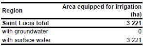
According to the agricultural census 2007 irrigation is used by 1 463 farms with a total extent of 8 206 acres (3 321 ha) [LC01]. It was assumed that AEI is similar to the reported extent of irrigated farms. The irrigated area is visible in the table below and also can be downloaded as Saint Lucia irrigation areas in PDF or Saint Lucia irrigation areas in Excel.
The irrigated area within the country was distributed to agricultural areas as indicated on a land use map from 1987 [LC02].
It was assumed that the whole AEI is irrigated with surface water because even for domestic purposes water from groundwater is exceptional [LC03]. This assumption is supported by a description of two main irrigation projects extracting water from the Cul-de-Sac and Roseau rivers [LC04].
References
[LC01]: Ministry of Agriculture Lands, Forestry and Fisheries. 2007. 2007 St. Lucia Census of Agriculture – Final report. Ministry of Agriculture Lands Forestry and Fisheries, Corporate Planning Unit, http://malff.com/images/stories/Census%20Data/Final%20Report.pdf, 12/03/2012.
[LC02]: Organization of American States. 1987. Saint Lucia Development Atlas. Organization of American States, Dpmt. of Regional Development.
[LC03]: FAO. 2000. AQUASTAT country profile of Saint Lucia, version 2000. FAO, Rome, Italy.
[LC04]: Ministry of Agriculture, Forestry and Fisheries, 2002. Report of irrigation project. Ministry of Agriculture, Forestry and Fisheries, Waterfront, Castries, Saint Lucia, http://www.slumaffe.org/Report\_of\_Irrigation\_Project.pdf, 27/08/2009.


