AQUASTAT - FAO's Global Information System on Water and Agriculture
Lithuania
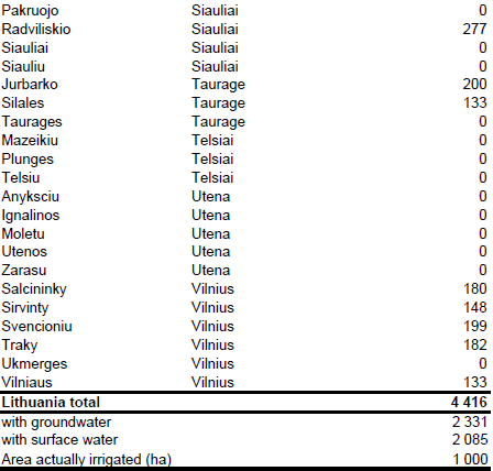
Area equipped for irrigation was 42 700 ha in 1990, the largest part of the irrigation infrastructure (29 900 ha) was located on meadows and pastures [LT01]. As private owners started working on small plots there was no need anymore for large scale irrigation infrastructure. Therefore area equipped for irrigation declined to 9 247 ha in 1995 [LT01], 8 122 ha in 1998 [LT02] and 4 416.3 ha in 2005 [LT03]. 3 920.9 ha of the area equipped for irrigation are located on artificial drained land [LT03]. Area equipped for irrigation by county and municipality was derived from an inventory related to year 2005 [LT03]. The irrigated area per county estimated that way is visible in the table below and also can be downloaded as Lithuania irrigation areas in PDF or Lithuania irrigation areas in Excel.

Today the main irrigated crops are potatoes and vegetables [LT04]. Since irrigation maps were not available for Lithuania, irrigated area was assigned to polygons as extracted from the Corine 2000 land cover database for Europe [LT05] classified as non-irrigated arable land (211) or complex cultivation patterns (242).
Based on the ratio between groundwater abstractions for irrigation and total water abstractions for irrigation in period 2003-2005 [LV06] area equipped for irrigation with groundwater was estimated at 2 331 ha (53 percent of total AEI). [LT06]. Area actually irrigated was set to 1 000 ha according to the EU farm structure survey 2007 [LT07].
References
[LT01]: FAO. 2012. AQUASTAT country profile of Lithuania, version 1997. FAO, Rome, Italy.
[LT02]: ICID. unknown. Country profile Lithuania. Lithuanian National Committee of ICID, 13 pp., http://www.icid.org, 14/02/2006.
[LT03]: Ministry of Agriculture. 2005. Register of Land equipped for irrigation on 01/01/2005. Data table provided by Dr. Antanas Maziliauskas, President of the Lithuanian National Committee of ICID on 09/03/2006.
[LT04]: Kucera, L. & Genovese, G. (ed.). 2004. Crop monographies on Central European countries – MOCA Study. Joint Research Centre of the European Commission, Directorate General, Institute for the Protection and Security of the Citizen, Agriculture & Fisheries Unit, Ispra, Italy, http://agrifish.jrc.it/marsstat/ Crop_Yield_Forecasting/MOCA/INDEX.HTM, 07/07/2006.
[LT05]: EEA. 2005. Corine land cover 2000 - vector by country (CLC2000), version 1. http://dataservice.eea.europa.eu/dataservice/metadetails.asp?id=667, 29/08/2005.
[LT06]: Statistical Office of the European Communities (EUROSTAT). 2011. Annual water abstraction by source and by sector. http://epp.eurostat.ec.europa.eu/portal/page/portal/ environment/data/database, 28/11/2011.
[LT07]: Statistical Office of the European Communities (EUROSTAT). 2011. Irrigable and irrigated areas. http://epp.eurostat.ec.europa.eu/portal/ page/portal/agri_environmental_indicators/data/ database, 28/11/2011.


