AQUASTAT - FAO's Global Information System on Water and Agriculture
Morocco
Area equipped for irrigation is 1 484 160 ha [MA01]. The figures refer to year 2004.
191 Irrigated areas for the northern part of the country were digitized from an irrigation map published in [MA02] while the main irrigated areas for the southern part were digitized from a map belonging to the AQUASTAT country profile [MA01]. For the northern part of the country additionally some irrigated areas were derived from the CORINE land cover database for Europe [MA03]. Finally the shapes of the boundaries of the digitized irrigation areas were improved by using satellite imagery [MA04]. The irrigated area per basin and per region is visible in the table below and also can be downloaded as Morocco irrigation areas in PDF or Morocco irrigation areas in Excel.
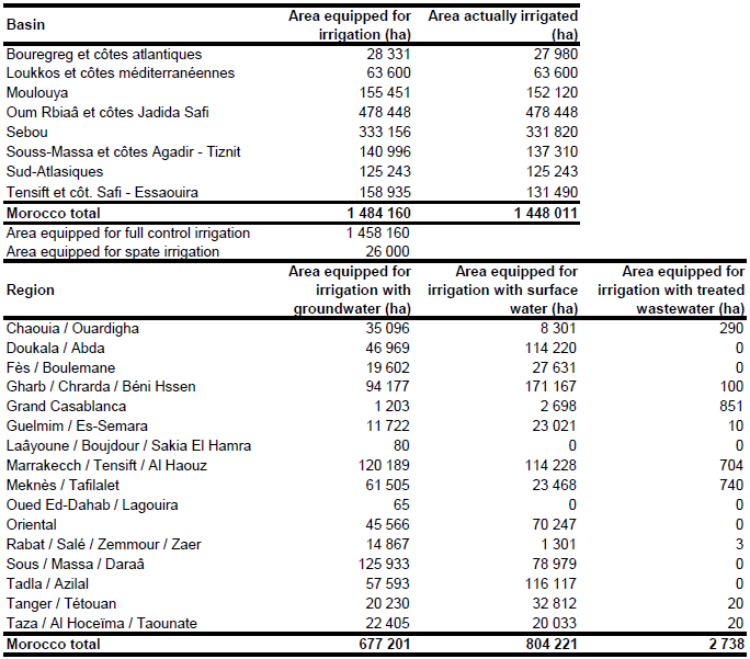
Area actually irrigated was 1 448 011 ha in year 2004 [MA01]. The separation of irrigated areas from groundwater and surface water for the public irrigation schemes was based on Table 3 in [MA05] and AQUASTAT data reported in Tables 12 and 13 of the country profile Morocco [MA01]. Irrigated area of private irrigation schemes was available for 16 regions distinguishing wells, springs, reservoirs, treated waste water, mixed sources and water from transfers [MA05]. The total area of private irrigation schemes in year 2002 was 626 609 ha and more than 90 percent used groundwater. In contrast, public irrigation schemes mainly used irrigation water extracted from surface water sources [MA01]. Total groundwater irrigation area computed that way was 677 201 ha (46 percent of total), area irrigated with surface water was 804 221 ha (54 percent) and the remaining 2 738 ha represent areas irrigated with treated wastewater.
References
[MA01]: FAO. 2005. AQUASTAT country profile Morocco, FAO, Rome, Italy.
[MA02]: Popp, H. 1993. Morocco's "policy of dams" and its consequences for irrigation agriculture (in german). In H. Popp & K. Rother, eds. Die Bewässerungsgebiete im Mittelmeerraum, pp. 161-164. Passau, Germany, Passavia Universitätsverlag.
[MA03]: EEA. 1999. Corine land cover (CLC1990), available at http://dataservice.eea.europa.eu/dataservice/.
[MA04]: Earth Satellite Corporation, 2004. Landsat GeoCover (2000/ETM+) Edition Mosaics, tiles 071-169, 071-181, 071-182, 071-183, 071-193, 071-194 and 071-195. Sioux Falls, USA, USGS (available at http://glcfapp.umiacs.umd.edu:8080/esdi/index.jsp).
[MA05]: FAO. 2008. Etude sur la gestion des eaux souterraines dans des pays pilotes du Proche-Orient. Etude de Cas du Maroc. Bureau régional de la FAO pour le Proche-Orient, Cairo, Egypt.


