AQUASTAT - FAO's Global Information System on Water and Agriculture
Malta
Area equipped for irrigation was 2 300 ha in 2003, while the area actually used for irrigation was 2 130 ha in the same year [MT01]. Sub-national irrigation statistics on the community level collected in the year 2001 reported an area equipped for irrigation of 1 509 ha [MT02]. The area equipped for irrigation by community was scaled so that the country totals are equal to the value reported for the year 2003 (2 300 ha). The irrigated area per community estimated that way is visible in the table below and also can be downloaded as Malta irrigation areas in PDF or Malta irrigation areas in Excel.
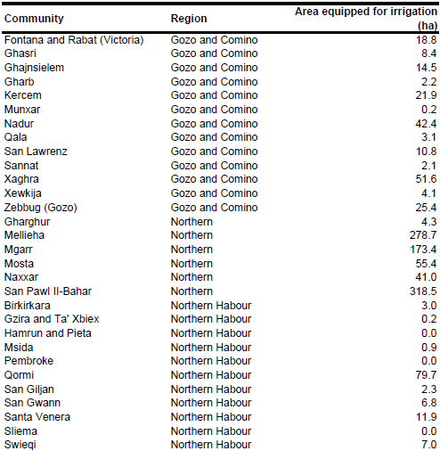

To distribute area equipped for irrigation within the communities, irrigated area was assigned to polygons extracted from the Corine 2000 land cover data base for Europe [MT03] classified as non-irrigated arable land (211), permanently irrigated land (212), vineyards (221), pastures (231), complex cultivation patterns (242) or land principally occupied by agriculture, with significant areas of natural vegetation (243).
Area equipped for irrigation with groundwater (2 287 ha) was computed based on the data collected by the EU farm structure survey 2003 as described before.
References
[MT01]: Statistical Office of the European Communities (EUROSTAT). 2011. Irrigable and irrigated areas. http://epp.eurostat.ec.europa.eu/portal/ page/portal/agri_environmental_indicators/data/ database, 28/11/2011.
[MT02]: National Statistics Office. 2004. Agriculture and fisheries 2002. Valletta, Malta, 175 pp., http://www.nso.gov.mt, 07/07/2006.
[MT03]: EEA. 2005. Corine land cover 2000 - vector by country (CLC2000), version 1. http://dataservice.eea.europa.eu/dataservice/metadetails.asp?id=667, 29/08/2005.


