AQUASTAT - FAO's Global Information System on Water and Agriculture
Montenegro
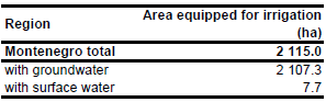
No statistics on area equipped for irrigation were available. However, the maximum of the area actually irrigated during the period 2001 - 2005 was reported at 2 115 ha for year 2005 [ME01]. It was assumed that this area also represents the area equipped for irrigation. No subnational statistics were available. The irrigated area is visible in the table below and also can be downloaded as Montenegro irrigation areas in PDF or Montenegro irrigation areas in Excel.
Since irrigation maps were not available for Montenegro, area equipped for irrigation was assigned to polygons extracted from the Corine 2000 land cover database for Europe [RS03] that were classified as non-irrigated arable land (211), vineyards (221), fruit trees and berry plantations (222), or complex cultivation patterns (242).
Average irrigation water use from groundwater within the period 2005-2007 was 7.3 Million m3 yr-1 while irrigation water extraction from surface water was only 25 Thousand m3 yr-1 [ME03]. Based on the ratio between irrigation water uses from the different water sources, area equipped for irrigation with groundwater was estimated at 2 108 ha.
References
[ME01]: Statistical Office of the Republic of Montenegro. 2006. Statistical Yearbook 2006. MONSTAT, Podgorica, Montenegro, 346 pp.
[ME02]: EEA. 2007. Corine land cover 2000 - vector by country (CLC2000), update for Serbia and Montenegro. http://dataservice.eea.europa.eu/dataservice/metadetails.asp?id=667, 03/04/2007.
[ME03]: Montenegro Statistical Office. 2008. Statistical Yearbook 2008. Montenegro Statistical Office (MONSTAT), Podgorica, Montenegro, http://www.monstat.cg.yu/EngPublikacije.htm, 24/08/2009.


