AQUASTAT - FAO's Global Information System on Water and Agriculture
Mauritius
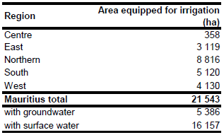
Area equipped for irrigation is 21 543 ha [MU01]. The figures refer to year 2009. The irrigated area per region is visible in the table below and also can be downloaded as Mauritius irrigation areas in PDF or Mauritius irrigation areas in Excel.
Irrigated areas were digitized from a map available in the AQUASTAT library [MU02]. The command area of the operating schemes of the Irrigation Authority was also indicated on this map (in total 4 571 ha). Irrigated area was also distributed to schemes classified as "operating projects by private sector". The remaining irrigated area was distributed to areas classified as "projects under design or construction" or "potential irrigable". For the Central district irrigated area was additionally assigned to cultivated areas as digitized from satellite imagery [MU03].
About 98 percent of the area equipped for irrigation are actually irrigated [MU04]. Groundwater is used for irrigation on 25 percent of the areas equipped for irrigation [MU04] while the remaining areas are using water from surface water sources.
References
[MU01]: Central Statistics Office. 2009. Digest of agricultural statistics 2009. http://www.gov.mu/portal/goc/cso/report/natacc/agri09/toc.htm, 06/10/2010.
[MU02]: Unknown. 2002. Irrigation projects. Map available in the AQUASTAT library.
[MU03]: Earth Satellite Corporation. 2004. Landsat GeoCover (2000/ETM+) Edition Mosaics, tile 071-729. Sioux Falls, USA, USGS (available at http://glcfapp.umiacs.umd.edu:8080/esdi/index.jsp).
[MU04]: FAO. 2005. AQUASTAT country profile Mauritius, FAO, Rome, Italy.


