AQUASTAT - FAO's Global Information System on Water and Agriculture
Malawi
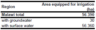
Area equipped for irrigation is 56 390 ha [MW01]. The figures refer to year 2002. Irrigated area per province was available for the 25 550 ha of formal irrigation only and neglected informal irrigation and parts of the small-scale irrigation. Therefore total area equipped for irrigation was not available at the sub-national scale. The irrigated area is visible in the table below and also can be downloaded as Malawi irrigation areas in PDF or Malawi irrigation areas in Excel.
The location and command area of 16 irrigation schemes was derived from the FAO irrigation map for Africa [MW02]. The total irrigated area of these projects was 15 855 ha. The outlines of the two largest schemes (Sucoma and Dwanga) with a command area of 13 000 ha were digitized from Satellite Imagery [MW03]. The satellite images were also used in the background to digitize cultivated areas near Nkota-Kota, Mulanje and Thyolo representing the areas of irrigated sugar cane, coffee or tea mentioned in the AQUASTAT country profile [MW01]. The remaining irrigated area (about 8 000 ha of small scale rice and vegetable growing areas) was assigned to areas classified as "cropland" in the GLC2000 land cover dataset for Africa [MW04].
In year 1992 about 96 percent of the area equipped for irrigation was actually irrigated and only 0.05 percent of the irrigated area was irrigated with groundwater [MW01]. It was assumed that these fractions were similar in year 2000.
References
[MW01]: FAO. 2006. AQUASTAT country profile Malawi, FAO, Rome, Italy.
[MW02]: FAO. 1987 (updated in 2005). Irrigated areas in Africa. FAO, Rome, Italy.
[MW03]: Earth Satellite Corporation, 2004. Landsat GeoCover (2000/ETM+) Edition Mosaics, tiles 071-699, 071-700 and 071-701. Sioux Falls, USA, USGS (available at http://glcfapp.umiacs.umd.edu:8080/esdi/index.jsp).
[MW04]: Mayaux, P., Bartholomé, E., Cabral, A., Cherlet, M., Defourny, P., Di Gregorio, A., Diallo, O., Massart, M., Nonguierma, A., Pekel, J.-F., Pretorius, C., Vancutsem, C., and Vasconcelos, M. 2003. The Land Cover Map for Africa in the Year 2000. European Commision Joint Research Centre, available at: http://www-gem.jrc.it/glc2000).


