AQUASTAT - FAO's Global Information System on Water and Agriculture
The Netherlands
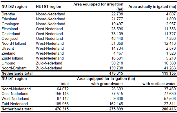
Area equipped for irrigation was available at the municipality level [NL01] and was summing up to 475 098 ha. However, for 19 out of the 544 municipalities the database had no data. After replacing these no-data-values by data using the reported irrigation densities in neighbouring municipalities total area equipped for irrigation was summing up to 476 315 ha. The irrigated areas by region are shown in the Table below. The irrigated areas both by region and by municipality can be downloaded as a The Netherlands irrigation areas in PDF or The Netherlands irrigation areas in Excel (two sheets).
The main irrigated crops in the Netherlands are grass, maize, potatoes and vegetables [NL02]. Irrigated area was therefore assigned to polygons extracted from the Corine 2000 land cover database for Europe [NL03] classified as non-irrigated arable land (211), pastures (231), complex cultivation patterns (242) or land principally occupied by agriculture, with significant areas of natural vegetation (243).
Area equipped for irrigation with groundwater was computed for 4 regions based on the data collected by the EU farm structure survey 2003 as described before. Area actually irrigated is varying from year to year depending on the specific climate in the reference year. In the wet growing season 1998/1999 area actually irrigated was only 123 300 ha while it was 308 700 ha in the dry growing season 1996/1997 [NL02]. Area actually irrigated per NUTS2-region was computed therefore as average of AAI reported by the EU farm structure surveys 2003, 2005 and 2007 [NL04]. Total AAI computed that way is summing up to 119 156 ha.
References
[NL01]: GIS-polygon shapefile provided by Timo Kroon, Rijkswaterstaat (RIZA) on 27/02/2006 and compiled for the Droogtestudie Nederland [NL02].
[NL02]: Hoogeveen, M.W., van Bommel, K.H.M. & Cotteleer, G. 2003. Beregening in land- en tuinbouw. Rapport voor de Droogtestudie Nederland. Rapport 3.03.02, LEI, Den Haag, Netherlands, 64 pp., http://www.lei.wur.nl/nl/publicaties+en+producten/leipublicaties/ ?n=3.03.02, 02/08/2006.
[NL03]: EEA. 2005. Corine land cover 2000 - vector by country (CLC2000), version 1. http://dataservice.eea.europa.eu/dataservice/metadetails.asp?id=667, 29/08/2005.
[NL04]: Statistical Office of the European Communities (EUROSTAT). 2011. Irrigable and irrigated areas. http://epp.eurostat.ec.europa.eu/portal/ page/portal/agri_environmental_indicators/data/ database, 28/11/2011.


