AQUASTAT - FAO's Global Information System on Water and Agriculture
Norway
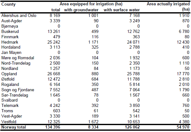
Area equipped for irrigation was increasing in Norway from 68 815 ha in 1979 to 90 670 ha in 1989 and 134 396 ha in 1999 [NO01]. Irrigation is mainly practiced on soils of low or moderate water holding capacity in South-East Norway in locations east of the mountains trapping rain water. However, in some isolated valleys in the inland the yearly amount of precipitation is down to 320 mm. Here agriculture (cereals/grass) is not possible without irrigation. The irrigated area per county is visible in the table below and also can be downloaded as Norway irrigation areas in PDF or Norway irrigation areas in Excel.
An inventory of soil properties on agricultural land [NO03] was used to distribute area equipped for irrigation within the counties. The inventory does not cover entire Norway but the largest part of the areas used for agricultural production. Among many other soil properties the inventory provides the water holding capacity of the topsoil (upper 60 cm) in four classes. Irrigated area was assigned to all soils of low water holding capacity (<50 mm) and to soils of moderate water holding capacity (50 – 90 mm). In total 77 845 ha of irrigated area were assigned to those soil regions. The remaining part of area equipped for irrigation was assigned to cultivated areas in regions not covered by the soil inventory and to soils of higher water holding capacity. Polygons for the cultivated land were extracted from a digital data set also available from the Norwegian Institute of Land Inventory [NO04]. This data set had a lower resolution but covered the entire country.
The percentage of AEI irrigated with groundwater was estimated by using the number of holdings irrigating by using ground- or surface water as reported for each county by the agricultural census 1999 [NO01]. Area actually irrigated per county was derived from the report of the farm structure survey 2007 as provided by EUROSTAT [NO05].
References
[NO01]: Statistics Norway. 2003. Census of agriculture 1999. Report No. NOS C 746, Oslo - Kongsvinger, Norway, 202 pp., http://www.ssb.no/english/subjects/10/04/10/nos\_jt1999\_en/, 07/07/2006.
[NO02]: Arnold Arnoldussen, Norwegian Institute of Land Inventory (NIJOS), personal communication.
[NO03]: Norwegian Institute of Land Inventory (NIJOS). 2006. Jordsmonndatabasen, Vanlagringsevne per commune. Maps in GIS-format, http://www.nijos.no/index.asp? topExpand=&subExpand=&menuid=1000523&strUrl=1002320i&context=14, 03/08/2006.
[NO04]: Norwegian Institute of Land Inventory (NIJOS). 2006. Arealressurskart AR 2000. Map in GIS-format, http://www.nijos.no/index.asp?topExpand=&subExpand=&menuid=1000458& strUrl=1002109i&context=17, 03/08/2006.
[NO05]: Statistical Office of the European Communities (EUROSTAT). 2011. Irrigable and irrigated areas. http://epp.eurostat.ec.europa.eu/portal/ page/portal/agri_environmental_indicators/data/ database, 28/11/2011.


