AQUASTAT - FAO's Global Information System on Water and Agriculture
Nepal
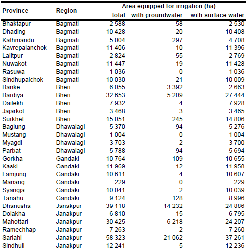
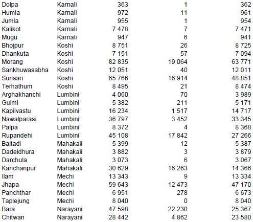
Area equipped for irrigation in Nepal is 1 168 349 ha [NP01]. The figures refer to cropping season 2001/2002 and were provided by the agricultural census for 75 districts as shown in the table below and in the downloadable Nepal irrigation areas in PDF or Nepal irrigation areas in Excel.

Area classified as irrigated cropland or as rainfed cropland was extracted from the Globcover regional land cover product for Central Asia [NP02]. Irrigated area was first assigned to pixels classified as irrigated cropland and then, if required, to areas classified as rainfed crops.
The extent of areas irrigated with ground- and surface water was derived for each district from the agricultural census database 2001/02 [NP01]. AEI irrigated with surface water was computed as the sum of net irrigated area from seasonal canals, perennial canals, ponds and tanks while AEI irrigated with groundwater was similar to irrigated area from tube-wells and wells. Additionally it was assumed that there is a similar fraction of AEI irrigated with groundwater in categories “other sources” and “mixed”. The large harvested area of irrigated crops (1 926 000 ha in year 2006) indicates a high cropping intensity on irrigated land [NP03]. It was therefore assumed that the whole area equipped for irrigation is actually irrigated.
References
[NP01]: Central Bureau of Statistics. 2013. National Sample Census of Agriculture 2001/02 - District Level Contents. http://cbs.gov.np/?p=570, 06/03/2013.
[NP02]: ESA. 2008. Regional Globcover Land Cover – Central Asia. Version 2.2. http://postel.mediasfrance.org/en/DOWNLOAD/, 24/03/2009.
[NP03]: FAO. 2013. AQUASTAT country profile of Nepal, version 2011. FAO, Rome, Italy.


