AQUASTAT - FAO's Global Information System on Water and Agriculture
Panama
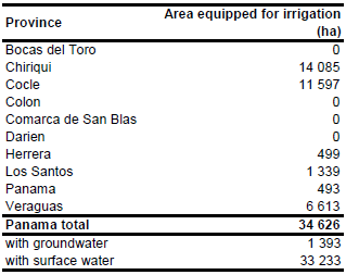
The total area equipped for irrigation in Panama equals 34 626 ha while area actually irrigated was 27 886 ha [PA01]. The figures per province originate from the AQUASTAT-library and refer to 1997. The irrigated area per province is visible in the table below and also can be downloaded as Panama irrigation areas in PDF or Panama irrigation areas in Excel.
The irrigated area within the provinces was distributed based on a map showing the location of 22 irrigation projects in 1997 [PA02]. The remaining area equipped for irrigation was equally distributed over area classified as “Agro-productive system” in the Central American Ecosystems Map [PA03].
Area equipped for irrigation with groundwater was 1 393 ha in year 2005 and located in the provinces of Herrera and Los Santos [PA04].
References
[PA01]: FAO. 2000. AQUASTAT country profile of Panama, version 2000. FAO, Rome, Italy.
[PA02]: Ministerio de Desarrollo Agropecuario. 1997. Plan Nacional de Riego.
[PA03]: World Bank and CCAD. 2001. Ecosystems of Central America (ArcView regional map files at 1:250,000). World Bank, Comisión Centroamericana de Ambiente y Desarrollo (CCAD), World Institute for Conservation and Environment (WICE), and the Centro Agronómico Tropical de Investigación y Enseñanza (CATIE), Washington, D.C., http://documents.worldbank.org/curated/en/504821468016811336/pdf/352550rev.pdf.
[PA04]: Ballestero, M., Reyes, V., & Astorga, Y. 2007. Groundwater in Central America: its importance, development and use, with particular reference to its role in irrigated agriculture. In: Giordano, M. & Villholth, K. G., The agricultural groundwater revolution. Opportunities and threads to development. International water Management Institute (IWMI), Colombo, Sri Lanka, 100-128, http://www.iwmi.cgiar.org/publications/latest/.


