AQUASTAT - FAO's Global Information System on Water and Agriculture
Poland
The extent of irrigated land reached its maximum in Poland in 1975 (408 700 ha) and declined later to 301 500 ha in 1990, 201 100 ha in 1995 and 83 292 ha in 2003. Sub-surface irrigation of permanent grasslands in wetlands and inland valley bottoms in combined drainage / irrigation schemes is dominant in Poland. The area of ameliorated grasslands is about 1 931 000 ha and about 25 percent of the drained grasslands are equipped with hydraulic structures that would in general allow to irrigate them. However, in 2004 only 89 000 ha of grasslands were classified as irrigable. The corresponding figures for arable land listed only 5 300 ha, mainly by micro-irrigation [PL01]. In contrast, the statistics published by EUROSTAT indicate that the extent of both, irrigable and actually irrigated area started recently to increase again. The irrigable area of Poland was reported at 98 420 ha in 2003 and 124 200 ha in 2005 while the area actually irrigated was 46 910 ha in 2003 and 70 450 ha in 2005 [PL02]. Because of the given uncertainties area equipped for irrigation was estimated for this study by selecting for each province the maximum of the areas reported as irrigable for the years 2003 and 2005. Area equipped for irrigation computed that way adds up to 134 050 ha. The irrigated area per province estimated that way is visible in the table below and also can be downloaded as Poland irrigation areas in PDF or Poland irrigation areas in Excel.
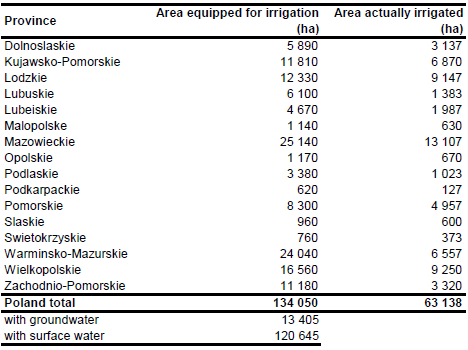
To distribute irrigated areas within the provinces, pasture areas were extracted from the Corine 2000 land cover database for Europe [PL03]. Additionally the major irrigation areas of the country were digitized from irrigation maps [PL04], [PL05]. Then irrigated area was assigned to all pasture polygons within the digitized irrigation areas or to pasture polygons that were located along the major rivers of the country.
90 percent of Poland’s irrigation area is irrigated with surface water and 10 percent with groundwater [PL01]. Area actually irrigated per district was computed as average of AAI reported by the EU farm structure surveys 2003, 2005 and 2007 [PL02]. Total AAI computed that way adds up to 63 138 ha.
References
[PL01]: Mioduszewski, W., Labedzki, L., Kuzniar, A., and Lipinski, J. 2006. Polish report. In: Dirksen, W. and Huppert, W. (ed.). Irrigation sector reform in Central and Eastern European countries. Deutsche Gesellschaft für Technische Zusammenarbeit (GTZ), Eschborn, Germany, 329-383.
[PL02]: Statistical Office of the European Communities (EUROSTAT). 2011. Irrigable and irrigated areas. http://epp.eurostat.ec.europa.eu/portal/ page/portal/agri_environmental_indicators/data/ database, 28/11/2011.
[PL03]: EEA. 2005. Corine land cover 2000 - vector by country (CLC2000), version 1. http://dataservice.eea.europa.eu/dataservice/metadetails.asp?id=667, 29/08/2005.
[PL04]: Framji, K.K., Garg, B.C. & Luthra, S.D.L. 1981. Irrigation and drainage in the world. Third edition. Vol. II, p. 1115. New Delhi, ICID.
[PL05]: Achtnich, W. 1980. Bewässerungslandbau. Map on p. 26, Ulmer, Stuttgart, Germany.


