AQUASTAT - FAO's Global Information System on Water and Agriculture
Puerto Rico (United States of America)
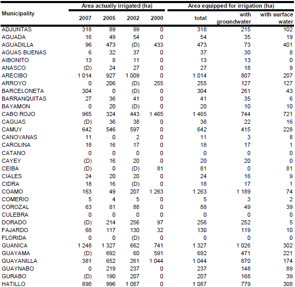
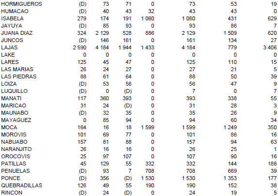
Area equipped for irrigation was estimated as the maximum of the area actually irrigated reported per municipality by the agricultural censuses 2007 [US01] and 2002 [US02] and by the water use censuses 2005 [US03] and 2000 [US04]. Total area equipped for irrigation computed that way was 91 421 acres (36 997 ha) and is visible in the table below and also can be downloaded as Puerto Rico irrigation areas in PDF or Puerto Rico irrigation areas in Excel.

Irrigated area in Puerto Rico was distributed to areas classified as agriculture/hay/pasture on a recent land cover map published in [US05]. However, in some sub-national units of Puerto Rico the irrigated area according to the sub-national statistics was higher than the irrigated area distributed according to the land cover map. In these cases (mainly small islands along the coastline) the difference was distributed equally over the most suitable grid cells using the USGS land cover classification map [US06].
Area actually irrigated in year 2007 was 39 707 cuerdas (15 776 ha) [US01]. Areas equipped for irrigation with groundwater or with surface water were computed by combining data on groundwater and surface water use for irrigation in year 2005 [US03] to data on the number of farms irrigated with water from wells, rivers and streams, lakes and private ponds or from canals [US01]. The data showed some disagreement, in particular at the municipality level. The water use inventory [US03] reported for example for several municipalities that irrigation water use is completely from groundwater while, according to the agricultural census report, many farms used water from surface water sources and vice versa. Therefore it was decided to use both inventories and to separate the water sources for half of the area equipped for irrigation according to the water use inventory [US03] and for the other half of the equipped area according to the agricultural census report [US01]. Area equipped for irrigation with groundwater computed that way was 24 848 ha (67 percent of the total area equipped for irrigation).
References
[US01]:NASS. 2009. Puerto Rico island and municipio data. 2007 Census of Agriculture, Volume 1, Geographic Area Series, Part 52, National Agricultural Statistics Service (NASS), US Department of Agriculture, http://www.agcensus.usda.gov/Publications/2007/index.asp, 01/02/2011.
[US02]: NASS. 2005. Puerto Rico. 2002 Census of Agriculture, Volume 1, Geographic Area Series, Part 52, National Agricultural Statistics Service (NASS), US Department of Agriculture, http://www.agcensus.usda.gov/Publications/2002/index.asp, 12/08/2009.
[US03]: Kenny, J.F., Barber, N.L., Hutson, S.S., Linsey, K.S., Lovelace, J.K., Maupin, M.A. 2009. Estimated use of water in the United States in 2005: U.S. Geological Survey Circular 1344, United States Geological Survey (USGS), http://water.usgs.gov/watuse/data/2005/index.html, 01/02/2011.
[US04]: Hutson, S.S., Barber, N.L., Kenny, J.F., Linsey, K.S., Lumia, D.S., Maupin, M.A. 2005. Estimated use of water in the United States in 2000: U.S. Geological Survey Circular 1268, United States Geological Survey (USGS), http://water.usgs.gov/watuse/data/2000/index.html, 12/08/2009.
[US05]: Helmer, E.H., Ramos, O., López, T.M., Quinones, M., Diaz, W. 2002. Mapping the forest type and land cover of Puerto Rico, a component of the Caribbean biodiversity hotspot. Caribbean Journal of Science 38, (3/4), 165-183.
[US06]: United States Geological Survey (USGS). 2002. Global Land Cover Characteristics database Version 2.0, http://lpdaac.usgs.gov/glcc/glcc.asp, 11/04/2005.


