AQUASTAT - FAO's Global Information System on Water and Agriculture
Romania
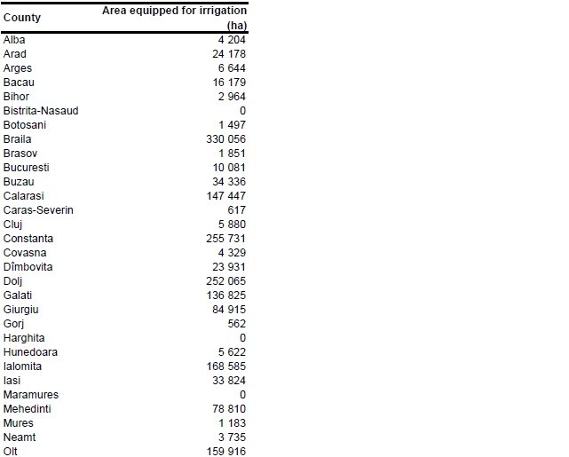
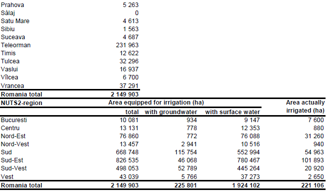
The total agricultural land reclaimed for irrigation reached its maximum in 1996 at 3 210 000 ha and declined later to 3 176 000 ha in 2003 [RO01]. However, from 1991 onwards a large part of the irrigation infrastructure was not used anymore. The minimum extent of the actually used irrigation areas was reported for the period 1998-2000 when less than 10 percent of the reclaimed irrigation area was irrigated [RO02]. At this time a program started to establish water user's associations and to transfer the on-farm irrigation infrastructure to them. Additionally an irrigation rehabilitation program, supported by the World Bank, started in regions of high crop water requirements. As a consequence of these activities the area actually used for irrigation was increasing again. Nevertheless it is very unlikely that all the former irrigation areas will be re-activated within the next years. A study carried out in 1994 with the support of the World Bank for example clearly indicated that irrigation is not economic in the higher terraces, even if agriculture redevelops, and should be discontinued so as not to waste further resources [RO02]. This, and the fact that a large part of the irrigation infrastructure has not been used for a long time shows that it is not useful to consider all the reclaimed irrigation area still as equipped for irrigation. EUROSTAT reported the irrigable area for the year 2003 at 1 510 820 ha [RO03], which is about half of the area developed in former times. These figures might refer to the so called 'area declared prepared for irrigation', which was 2 121 238 ha in 1999, 1 502 642 ha in 2000, 900 678 ha in 2001 and 1 222 000 ha in 2002 [RO02]. For this study area equipped for irrigation was taken out of a table published in [RO01] listing the total area of schemes in counties where water user's associations are established (as per 31/12/2004). The statistics were given for 24 counties covering by far the largest part of the former irrigation zones and were summing up to 2 021 911 ha. Area equipped for irrigation for the other counties was estimated based on a map published in the same report showing the former reclaimed irrigation areas. The total area equipped for irrigation computed that way for the 17 counties missing in the statistics was 127 992 ha which gives a total sum of 2 149 903 ha for the whole country. The irrigated area per county estimated that way is visible in the table below and also can be downloaded as Romania irrigation areas in PDF or Romania irrigation areas in Excel.
Area equipped for irrigation was assigned to polygons extracted from the Corine 2000 land cover database for Europe [RO04] that were located within the digitized irrigation areas and that were classified as non-irrigated arable land (211), permanently irrigated land (212), rice fields (213), vineyards (221), fruit trees and berry plantations (222), pastures (231), complex cultivation patterns (242) or land principally occupied by agriculture, with significant areas of natural vegetation (243).
Area equipped for irrigation with groundwater was computed for 8 regions based on the data collected by the EU farm structure survey 2003 as described before. Area actually irrigated per NUTS2-region was computed as average of AAI reported by the EU farm structure surveys 2003, 2005 and 2007 [RO03]. Total AAI computed that way adds up to 221 106 ha.
References
[RO01]: Nicolaescu, I., Buhociu, L., Condruz, R., Suciu, G.-I., Paraschiv, D. & Boeru, M. 2006. Country report from Romania. In: Dirksen, W. and Huppert, W. (ed.). Irrigation sector reform in Central and Eastern European countries. Deutsche Gesellschaft für Technische Zusammenarbeit (GTZ), Eschborn, Germany, 385-462.
[RO02]: World Bank. 2003. Irrigation rehabilitation and reform project. Project appraisal document. Report No: 26273-RO, http://www-wds.worldbank.org/, 07/07/2006.
[RO03]: Statistical Office of the European Communities (EUROSTAT). 2011. Irrigable and irrigated areas. http://epp.eurostat.ec.europa.eu/portal/ page/portal/agri_environmental_indicators/data/ database, 28/11/2011.
[RO04]: EEA. 2005. Corine land cover 2000 - vector by country (CLC2000), version 1. http://dataservice.eea.europa.eu/dataservice/metadetails.asp?id=667, 29/08/2005.


