AQUASTAT - FAO's Global Information System on Water and Agriculture
Senegal
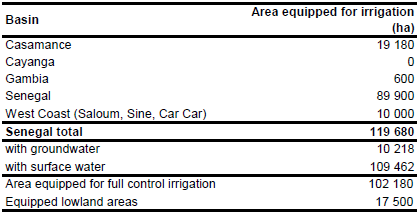
Area equipped for irrigation is 119 680 ha [SN01]. The figures refer to year 2002. No sub-national information on areas equipped for irrigation was available. However, based on statistics in reports [SN02] and [SN03] 19 180 ha irrigated area were assigned to Casamance basin, 10 000 ha to West Coast basins (Saloum, Sine and Car Car), 600 ha to Senegal oriental (Gambia basin) and the remaining 89 900 ha were assigned to the Senegal river basin. The irrigated area per basin estimated that way is visible in the table below and also can be downloaded as Senegal irrigation areas in PDF or Senegal irrigation areas in Excel.
The location and extent of 7 large scale irrigation schemes (in total 15 500 ha) was derived from the FAO irrigation map for Africa [SN04]. Additionally, irrigated land mapped in a land use dataset [SN05] was extracted and cultivated land close to the Senegal river, in the Niayes zone and along the other major rivers was digitized from satellite imagery [SN06].
Area actually irrigated was 69 000 ha in year 1996 while area equipped for irrigation with groundwater was 10 218 ha (10 percent of irrigated area in full/partial control schemes) in year 2002 [SN01].
References
[SN01]: FAO. 2005. AQUASTAT country profile Senegal, FAO, Rome, Italy.
[SN02]: FAO. 1999. Sénégal – Stratégie de développement de la petite irrigation et plan d’action. 99/025 CP-SEN.
[SN03]: Association Régionale de l'Irrigation et du Drainage en Afrique de l'Ouest et du Centre. 2003. Compte-rendu de l'atelier de lancement du projet APPIA au Sénégal.
[SN04]: FAO. 1987 (updated in 2005). Irrigated areas in Africa. FAO, Rome, Italy.
[SN05]: Leonardi, U. 2008. Senegal Land Cover Mapping. Food and Agriculture Organization of the United Nations, http://www.fao.org/fileadmin/user_upload/geospatial/docs/Land_Cover/Senegal_LC/Senegal_LC_Report_1208.pdf.
[SN06]: Earth Satellite Corporation, 2004. Landsat GeoCover (2000/ETM+) Edition Mosaics, tiles 071-166 and 071-167. Sioux Falls, USA, USGS (available at http://glcfapp.umiacs.umd.edu:8080/esdi/index.jsp).


