AQUASTAT - FAO's Global Information System on Water and Agriculture
El Salvador
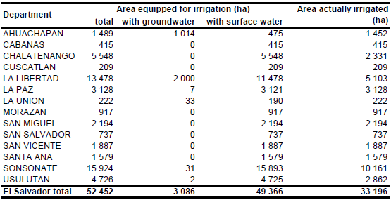
Area equipped for irrigation increased from 44 993 ha in year 1997 [SV01] to 45 027 ha in year 2005 [SV02], but according to the report of the agricultural census 2007/2008 area actually used for irrigation was only 47 504 Manzanas (33 196 ha) [SV03]. The maximum of AEI reported in [SV02] and AAI reported in [SV03] was assigned the each department as AEI (52 452 ha in total) while AAI was set to the acreage reported by the agricultural census [SV03]. The irrigated area per department estimated that way is visible in the table below and also can be downloaded as El Salvador irrigation areas in PDF or El Salvador irrigation areas in Excel.
The distribution of irrigated areas within the country is mainly based on a World Bank study on private irrigation from the year 1993 [SV04]. Additional information comes from a government register of irrigation water user associations [SV05]. The remaining area equipped for irrigation was equally distributed over area classified as “Agro-productive system” in the Central American Ecosystems Map [SV06].
Area equipped for irrigation with groundwater was 3 086.3 ha in year 2005. These figures are based on statistics provided by the Department of Irrigation and Drainage, Ministry of Agriculture and Livestock reported in a report on groundwater use in Central America [SV07].
References
[SV01]: FAO. 2000. AQUASTAT country profile of El Salvador. FAO, Rome, Italy.
[SV02]: Division de Riego y Drenaje. 2007. Superficie bajo riego en El Salvador. http://www.mag.gob.sv/main/index.php?ids=253, 19/03/2009.
[SV03]: Ministerio de Economia. 2009. El Salvador, C.A., IV Censo Agropecuario 2007-2008. Metodología y Resultados Generales. Ministerio de Economia, http://www.censos.gob.sv/ util/datos/CENAGRO_0708.PDF, 01/03/2012.
[SV04]: World Bank. 1993. Central America - Subsector Study on private Irrigation, Mapas El Salvador, Mapa 3.
[SV05]: Division de Riego y Drenaje. 1999. Listado de Asociaciones de Regantes.
[SV06]: World Bank and CCAD. 2001. Ecosystems of Central America (ArcView regional map files at 1:250,000). World Bank, Comisión Centroamericana de Ambiente y Desarrollo (CCAD), World Institute for Conservation and Environment (WICE), and the Centro Agronómico Tropical de Investigación y Enseñanza (CATIE), Washington, D.C., http://www.birdlist.org/cam/themes/ map_download_page.htm, 15/11/2010.
[SV07]: Ballestero, M., Reyes, V., & Astorga, Y. 2007. Groundwater in Central America: its importance, development and use, with particular reference to its role in irrigated agriculture. In: Giordano, M. & Villholth, K. G., The agricultural groundwater revolution. Opportunities and threads to development. International water Management Institute (IWMI), Colombo, Sri Lanka, 100-128, http://www.iwmi.cgiar.org/Publications/CABI\_Publications/index.aspx, 12/08/2009.


