AQUASTAT - FAO's Global Information System on Water and Agriculture
Suriname
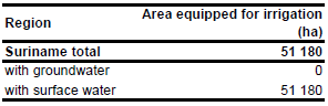
For Suriname no information could be found on irrigated areas on sub-national level. In total there are 51 180 ha equipped for irrigation. The figure refers to 1998 [SR01]. The irrigated area is visible in the table below and also can be downloaded as Suriname irrigation areas in PDF or Suriname irrigation areas in Excel.
The irrigated area within the country was distributed to important agricultural projects as indicated on a map from the year 1969 [SR02].
Only surface water is used for irrigation, although suitable groundwater resources are available in many regions as well [SR03].
References
[SR01]: FAO. 2000. AQUASTAT country profile of Suriname, version 2000. FAO, Rome, Italy.
[SR02]: Framji, K.K., Mahajan, I.K. 1969. Irrigation and Drainage in the World. International Commission on Irrigation & Drainage, New Delhi, India.
[SR03]: US Army Corps of Engineers. 2001. Water Resources Assessment of Suriname. http://www.sam.usace.army.mil/en/wra/Suriname/Suriname Water Resources Assessment.pdf, 12/03/2012.


