AQUASTAT - FAO's Global Information System on Water and Agriculture
Slovakia
Irrigation infrastructure was constructed on 308 200 ha of agricultural land [SK01], but area equipped for irrigation declined to 225 310 ha in year 2001 [SK02] which means that parts of the former infrastructure cannot be used anymore. Area equipped for irrigation per region was derived from the database of the farm structure census 2001 [SK02]. The irrigated area per region estimated that way is visible in the table below and also can be downloaded as Slovakia irrigation areas in PDF or Slovakia irrigation areas in Excel.
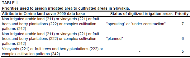
The main irrigation areas of the country were digitized from an irrigation map. The map showed areas in operation, areas under construction and planned irrigation areas of the former Czechoslovakia [SK03]. Irrigated area was then assigned to cultivated land extracted from the Corine 2000 land cover data base for Europe [SK04] using the priorities shown in Table 1. In the regions of Zilina and Presov irrigated area was assigned to all areas classified as vineyards (221), fruit trees and berry plantations (222) or complex cultivation patterns (242) because none of the digitized irrigation areas was located within these regions.
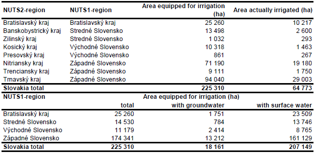
Area equipped for irrigation with groundwater was computed for 4 regions based on the data collected by the EU farm structure survey 2003 as described before. Area actually irrigated was computed for 8 regions as average of AAI reported by the farm structure surveys 2001, 2005 and 2007 [SK05]. AAI per region computed that way added up to 64 773 ha.
References
[SK01]: Slovak National Committee of ICID. unknown. Slovak Republic. ICID country profile http://icid.org/index\_e.html, 07/07/2003.
[SK02]: Statistical Office of the Slovak Republic. 2002. Farm structure census 2001. http://www.statistics.sk/webdata/english/index2\_a.htm, 06/08/2006.
[SK03]: Framji, K.K., Garg, B.C. & Luthra, S.D.L. 1981. Irrigation and drainage in the world. Third edition. Vol. I, p. 304. New Delhi, ICID.
[SK04]: EEA. 2005. Corine land cover 2000 - vector by country (CLC2000), version 1. http://dataservice.eea.europa.eu/dataservice/metadetails.asp?id=667, 29/08/2005.
[SK05]: Statistical Office of the European Communities (EUROSTAT). 2011. Irrigable and irrigated areas. http://epp.eurostat.ec.europa.eu/portal/ page/portal/agri_environmental_indicators/data/ database, 28/11/2011.


