AQUASTAT - FAO's Global Information System on Water and Agriculture
Slovenia
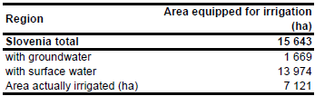
The area equipped for irrigation was 6 500 ha in 1995, most of it located in the Savinja valley, Podravje region and Vipava valley [SI01]. After a severe drought (1992-1993) a National Irrigation Program was prepared and based on a feasibility study undertaken by the World Bank (1997-1999) the development of an additional irrigation area of 10 000 ha was suggested [SI02]. The total area equipped for irrigation is now 15 643 ha in Slovenia [SI03], as shown in the table below, aslo downloadable as Slovenia irrigation areas in PDF or Slovenia irrigation areas in Excel. It is necessary to draw attention to the fact that the irrigated area of the country is underestimated in the official statistical yearbook [SI04] and in the statistics reported by EUROSTAT [SI05] as well. The reason maybe that most of the irrigation facilities are of very small extent and many of them operate without any authorization for water withdrawal [SI02].
No updated sub-national irrigation statistics have been available, but, instead of it, a rather detailed map showing the location and extent of the single irrigation areas [SI06]. Area equipped for irrigation was distributed equally over the polygons digitized from this map.
Area equipped for irrigation with groundwater was computed based on the data collected by the EU farm structure survey 2003 as described before. Area actually irrigated (7 121 ha) was computed based on the ratio between actually irrigated area and equipped area reported for years 2003-2007 in a pilot study undertaken to prepare the agricultural census 2010 [SI07].
References
[SI01]: World Bank. 1997. Slovenia – Irrigation project. Working paper 3: Water resources and irrigation in Slovenia. Report available in the AQUASTAT library.
[SI02]: Maticic, B. & Steinman, F. 2006. Country report from Slovenia. In: Dirksen, W. and Huppert, W. (ed.). Irrigation sector reform in Central and Eastern European countries. Deutsche Gesellschaft für Technische Zusammenarbeit (GTZ), Eschborn, Germany, 525-606.
[SI03]: Maticic, B. (President of Slovenian National Committee on Irrigation and Drainage), personal communication. [SI04]: Statistical Office of the Republic of Slovenia. 2006. Statistical Yearbook of the Republic of Slovenia 2005.
http://www.stat.si/letopis/index\_letopis\_en.asp, 06/08/2006.
[SI05]: Statistical Office of the European Communities (EUROSTAT). 2011. Irrigable and irrigated areas. http://epp.eurostat.ec.europa.eu/portal/ page/portal/agri_environmental_indicators/data/ database, 28/11/2011.
[SI06]: Unknown. Irrigation areas in Slovenia. Map, provided by Prof. Dr. Maticic (President of Slovenian National Committee on Irrigation and Drainage) on 13/04/2006 showing the location and extent of the Slovenian irrigation schemes.
[SI07]: Pintar, M. & Maver, D. 2009. Pilot studies on estimating the volume of water used for irrigation. Final Report. Table 6: Irrigated areas in Slovenia, Survey on water for irrigation (Environmental statistics). Statistical Office of the Republic of Slovenia, http://www.stat.si/eng/PrikaziDatoteko.aspx?id=3566, 04/04/2011.


