AQUASTAT - FAO's Global Information System on Water and Agriculture
Sweden
Area equipped for irrigation for 8 regions was derived from the statistics of the farm structure survey 2003. AEI reported for the regions added up to 188 470 [SE01] as shown in table below and in the downloadable Sweden irrigation areas in PDF or Sweden irrigation areas in Excel. Since these 8 regions are still pretty large and statistics on area equipped for irrigation were not available at higher resolution, statistics on irrigation water consumption [SE02] were used to downscale the irrigated area statistics to counties and municipalities. It is very likely that this procedure introduced an unknown error since irrigation water use per unit area is varying. However, it helped to identify the main zones of irrigation infrastructure development.
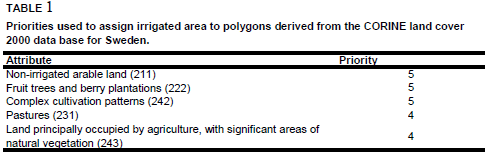
Irrigation maps were not available for Sweden. Instead of it area equipped for irrigation was assigned to polygons extracted from the Corine 2000 land cover database for Europe [SE03] using the priorities shown in Table 1.
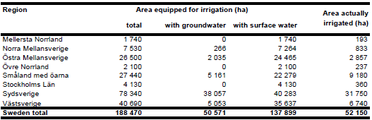
Area equipped for irrigation with groundwater was computed for 8 regions based on the data collected by the EU farm structure survey 2003 as described before. Area actually irrigated for the same regions was computed as average of the AAI reported in the farm structure surveys 2003, 2005 and 2007 [SE01]. AAI computed this way added up to 52 150 ha.
References
[SE01]: Statistical Office of the European Communities (EUROSTAT). 2011. Irrigable and irrigated areas. http://epp.eurostat.ec.europa.eu/portal/ page/portal/agri_environmental_indicators/data/ database, 28/11/2011.
[SE02]: Statistiska centralbyrån. 1999. Vattenuttag och vattenanvändningen i Sverige 1995. Report No: Mi 27 SM 9901, Stockholm, Sweden, 67 pp.
[SE03]: EEA. 2005. Corine land cover 2000 - vector by country (CLC2000), version 1. http://dataservice.eea.europa.eu/dataservice/metadetails.asp?id=667, 29/08/2005.


