AQUASTAT - FAO's Global Information System on Water and Agriculture
Trinidad & Tobago
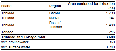
For Trinidad and Tobago no information could be found on irrigated areas on sub-national level. In the whole of Trinidad and Tobago 3 600 ha are equipped for irrigation. The figure refers to 1997 [TT01]. However, extent of AEI in the districts of Tobago (216 ha), Caroni (1 739 ha) and Nariva (147 ha) was derived from the AQUASTAT country profile [TT01]. The irrigated area is visible in the table below and also can be downloaded as Trinidad and Tobago irrigation areas in PDF or Trinidad and Tobago irrigation areas in Excel.
The irrigated area within the country was distributed over rice growing areas as indicated on a map from 1977 [TT02] and over cropping areas as indicated on an agricultural map of 1969 [TT03].
Data related to the source of irrigation water were not available for Trinidad and Tobago. However, surface water resources were reported to be much larger than groundwater resources and the largest irrigation scheme of the country uses water diverted from the Caroni River [TT01]. It was furthermore reported that small scale private developments use water extracted from small streams. Based on this information the percentage of irrigated area that is using groundwater was estimated at 10 percent.
References
[TT01]: FAO. 2000. AQUASTAT country profile of Trinidad and Tobago, version 2000. FAO, Rome, Italy.
[TT02]: Government of Trinidad and Tobago. 1977. Topo maps 1:25000, Series 804, Edition 1.
[TT03]: Instituto Geografico de Agostini. 1969. World Atlas of Agriculture.


