AQUASTAT - FAO's Global Information System on Water and Agriculture
United Republic of Tanzania
According to an inventory of irrigation schemes prepared for the National Irrigation Master Plan (NIMP), area equipped for irrigation was 184 330 ha in year 2002 [TZ01]. In contrast the agricultural census 2003 reported 166 710 ha of area equipped for irrigation in small-scale farms [TZ02] and 27 054 ha in large-scale farms [TZ03], which is summing up to 193 764 ha. Both inventories disagreed significantly in reported irrigated areas, in particular at the district level but also at the region level. Reasons for the disagreement maybe that the census was a sample census considering less than 30 percent of all villages and the use of different definitions for irrigated land (e.g. related to rainwater harvesting). Area equipped for irrigation was therefore computed as the average of the irrigated areas reported by the census reports and the NIMP (189 047 ha in total). The irrigated area per region estimated that way is visible in the table below and also can be downloaded as United Republic of Tanzania irrigation areas in PDF or United Republic of Tanzania irrigation areas in Excel.
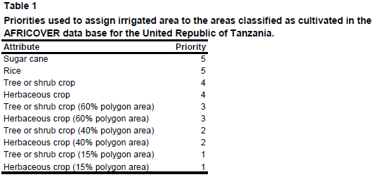
Irrigated area was assigned first to 517 irrigation projects derived from the FAO irrigation map for Africa [TZ04] or digitized from another irrigation map [TZ05]. The remaining irrigated area was assigned to areas classified as cultivated by the FAO AFRICOVER land cover data base ([TZ06], [TZ07]) using the priorities given in Table 1.
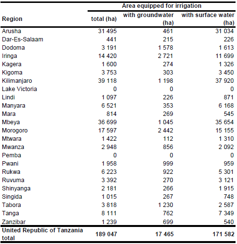
It was assumed that area actually irrigated was similar to area equipped for irrigation [TZ08]. Area equipped for irrigation with groundwater was computed based on the number of farms using the water sources river, lake, canal, dam, well, and borehole reported for each district in the census reports ([TZ02], [TZ03]), resulting in an area irrigated with groundwater of 17 465 ha (9.2 percent of total area equipped for irrigation) while the remaining area is irrigated by using surface water sources.
References
[TZ01]: Ministry of Agriculture and Food Security (MAFS) and Japan International Cooperation Agency (JICA). 2002. The Study on the National Irrigation Master Plan in the United Republic of Tanzania. Prepared by Nippon Koei CO. Ltd. and Nippon Giken Inc.
[TZ02]: National Bureau of Statistics. 2007. National sample census of agriculture 2002 / 2003. Volume V, Regional reports. National Bureau of Statistics, Ministry of Agriculture and Food Security, Ministry of Water and Livestock Development, Ministry of Cooperatives and Marketing, Presidents Office, Regional Administration and Local Government, Ministry of Finance and Economic Affairs – Zanzibar, Dar es Salaam, Tanzania, http://www.kilimo.go.tz/statistics/statistics.php, 28/08/2009.
[TZ03]: National Bureau of Statistics. 2006. National sample census of agriculture 2002 / 2003. Large Scale Farm Report. National Bureau of Statistics, Ministry of Agriculture and Food Security, Ministry of Water and Livestock Development, Ministry of Cooperatives and Marketing, Presidents Office, Regional Administration and Local Government, Ministry of Finance and Economic Affairs – Zanzibar, Dar es Salaam, Tanzania, http://www.kilimo.go.tz/statistics/statistics.php, 28/08/2009.
[TZ04]: FAO. 1987 (updated in 2005). Irrigated areas in Africa. FAO, Rome, Italy.
[TZ05]: Unknown. Distribution of irrigation schemes on irrigation development potential map. Map available in the AQUASTAT library.
[TZ06]: FAO. 2005. AFRICOVER, Tanzania - Spatially Aggregated Multipurpose Landcover database. FAO, Rome, Italy, http://www.africover.org, 13/12/2004.
[TZ07]: FAO. 2005. AFRICOVER, Tanzania - Thematically Aggregated Multipurpose Landcover database. FAO, Rome, Italy, http://www.africover.org, 13/12/2004.
[TZ08]: FAO. 2005. AQUASTAT country profile United Republic of Tanzania, FAO, Rome, Italy.


