AQUASTAT - FAO's Global Information System on Water and Agriculture
United States of America
Conterminous and Hawaii
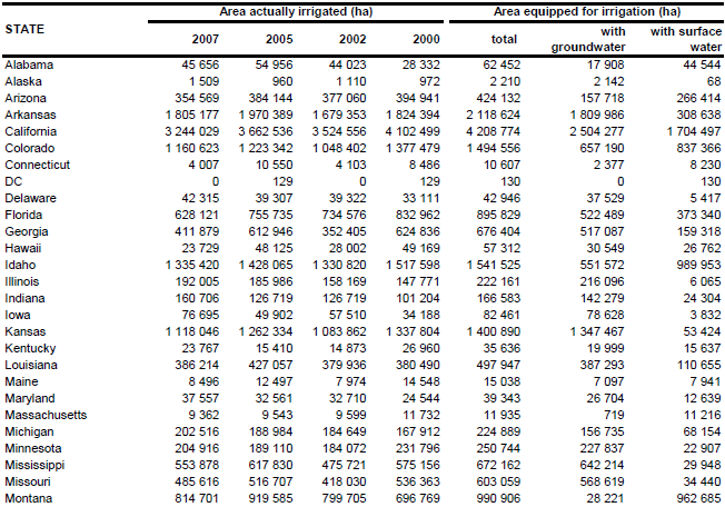
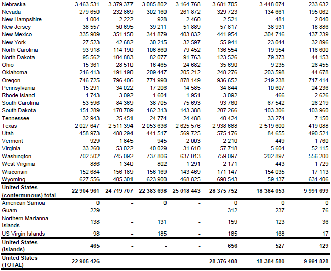
The area equipped for irrigation is not known for the United States of America. The 16th census of the United States, undertaken in 1940 and published in 1942, reported for the last time the so called “Area of irrigation works were capable of supplying with water” which comes close to the definition of area equipped for irrigation used here. At that time this area was 28 055 248 acres while the area actually irrigated in year 1939 (called “area irrigated” in the census report) was 21 003 739 acres (75 percent of the equipped area). Beginning with the 1950 Censuses of Agriculture, Irrigation and Drainage the area actually irrigated in the year of the census survey is reported, which is similar to the area actually irrigated used here. Therefore, area equipped for irrigation was estimated by selecting for each county the maximum of the area actually irrigated reported in the agricultural censuses 2007 [US07] and 2002 [US08] and the water use censuses for year 2005 [US03] and year 2000 [US04]. Total area equipped for irrigation computed that way was 70 118 017 acres (28 375 752 ha) (including Alaska and Hawaii but excluding the islands of Guam, Virgin Islands and Northern Marianna Islands). The irrigated areas by state are shown in the Table below. The irrigated areas both by state and by county can be downloaded as United States of America irrigation areas in PDF or United States of America irrigation areas in Excel (two sheets). A similar procedure is also being used by the Natural Resources Conservation Service (NRCS) of USDA, who defined irrigated land as "Land that shows evidence of being irrigated during the year of the inventory or during two or more years out of the last four years" (http://www.nrcs.usda.gov/technical/NRI/maps/meta/m5297.html). The irrigated area computed this way by the NCRS was 67.5 million acres (27.3 million ha) for year 1997. However, the NRCS data were unfortunately not available at the county level.
A national land cover data set on a 30 m resolution [US09] was used to assign areas equipped for irrigation to specific cells within the sub-national units of the conterminous United States. Irrigated area of the sub-national units was equally distributed over all cells classified as orchards and vineyards (value 61), row crops (value 82), small grains (value 83) or fallow (value 84). If the sum of these cropland areas was smaller than the total irrigated area per sub-national unit, the remaining area was assigned to cells classified as pasture and hay (value 81). This appeared in the majority of the sub-national units in the states of Arizona, California, Colorado, Idaho, Nevada, New Mexico, Oregon, Utah, Washington and Wyoming and in some sub-national units located in the states of Arkansas, Florida, Massachusetts, Missouri, Montana, Nebraska and Texas. This land cover data set was not available for Alaska and Hawaii. Therefore, a similar land cover data set with the same resolution [US10] was used for the Hawaiian Islands. Irrigated area was assigned to all cells classified as cultivated land (class 4). Additionally areas close to cropland-cells and classified as grassland (class 5) were assumed to be irrigated on the islands of Honolulu and Kauai. The GLC2000 land cover classification for North America [US11] was used to distribute irrigated areas within the sub-national units of Alaska. The highest priority was given to cells classified as cropland (class 18). If the sum of the areas classified as cropland was lower than the irrigated area as reported by the statistical surveys also cells classified as mosaic of cropland and other land cover types were considered.
Area actually irrigated was 56 599 305 acres (22 904 924 ha) in year 2007 [US07]. The percentage of area irrigated with groundwater was derived for each federal state from the most recent Farm and Ranch Irrigation Survey (FRIS) of the US Department of Agriculture [US12]. The FRIS was used as the primary source of information for the United States because it is based on questionnaires filled by the irrigating farmers themselves and provides likely the most complete and detailed profiles of irrigation in the United States. These statistics reported the extent of irrigated areas using wells, on-farm surface water and off-farm surface water. According to this survey 66 percent of the irrigated land was irrigated from wells. However, the average amount of water applied per acre varied significantly by source with lower values for wells and largest values for off-farm surface water supply. Therefore, only 53 percent of the irrigation water application was from wells. Since the FRIS is only reporting statistics at the state level, these statistics were downscaled to the county level by using data on irrigation water extraction from ground- and surface water ([US03], [US04]) by assuming that the ratio between irrigated areas from ground- and surface water was similar to the ratio between groundwater use and surface water use for irrigation.
References
[US03]: Kenny, J.F., Barber, N.L., Hutson, S.S., Linsey, K.S., Lovelace, J.K., Maupin, M.A. 2009. Estimated use of water in the United States in 2005: U.S. Geological Survey Circular 1344, United States Geological Survey (USGS), http://water.usgs.gov/watuse/data/2005/index.html, 01/02/2011.
[US04]: Hutson, S.S., Barber, N.L., Kenny, J.F., Linsey, K.S., Lumia, D.S., Maupin, M.A. 2005. Estimated use of water in the United States in 2000: U.S. Geological Survey Circular 1268, United States Geological Survey (USGS), http://water.usgs.gov/watuse/data/2000/index.html, 12/08/2009.
[US07]: NASS. County level data. 2007 Census of Agriculture, Volume 1, Chapter 2, National Agricultural Statistics Service (NASS), US Department of Agriculture, http://www.agcensus.usda.gov/Publications/2007/Full\_Report/ Volume_1,_Chapter_2_County_Level/index.asp, 01/02/2011.
[US08]: NASS. County level data. 2002 Census of Agriculture, Volume 1, Chapter 2, National Agricultural Statistics Service (NASS), US Department of Agriculture, http://www.agcensus.usda.gov/Publications/2002/ Volume_1,_Chapter_2_County_Level/index.asp, 12/08/2009.
[US09]: U.S. Geological Survey (USGS) and U.S. Environmental Protection Agency (USEPA). 1999. National Land Cover Data (NLCD). http://landcover.usgs.gov/natllandcover.asp, 12/01/2005.
[US10]: National Oceanic and Atmospheric Administration (NOAA) Coastal Services Center. 2004. Main Eight Hawaiian Islands Land Cover. http://www.csc.noaa.gov/crs/lca/hawaii.html, 15/02/2005.
[US11]: Latifovic, R., Zhu, Z., Cihlar, J., Beaubien, J., Fraser, R. 2003. The Land Cover Map for North America in the Year 2000, map version 2. GLC2000 database, European Commision Joint Research Centre, http://www.gvm.jrc.it/glc2000, 12/01/2005.
[US12]: NASS. 2010. Farm and Ranch Irrigation Survey (2008). 2007 Census of Agriculture, Volume 3, Special Studies, Part 1, National Agricultural Statistics Service (NASS), US Department of Agriculture, http://www.agcensus.usda.gov/Publications/2007/Online\_Highlights/ Farm_and_Ranch_Irrigation_Survey/index.asp , 01/02/2011.
American Samoa
The most recent agricultural census report did not indicate any use of irrigation in American Samoa [AS01]. Because of the humid climate conditions there is likely no requirement for irrigation in agriculture.
References
[AS01]: NASS. 2005. American Samoa. 2003 Census of Agriculture, Volume 1, Geographic Area Series, Part 55, National Agricultural Statistics Service (NASS), United States Department of Agriculture, http://www.agcensus.usda.gov/Publications/2002/index.asp, 12/08/2009.
Guam
Area equipped for irrigation (772 acres or 312 hectares) was estimated as the maximum of the area actually irrigated reported in the reports of the agricultural censuses 2007 [GU01] and 2002 [GU02].
Since no direct or indirect information about the spatial distribution of irrigation was available for Guam, irrigated area was distributed according to a global land cover data set [GU03] to all areas classified as: “Dryland Cropland and Pasture”, “Irrigated Cropland and Pasture”, “Cropland/Grassland Mosaic”, “Cropland/Woodland Mosaic”, “Grassland”, “Shrubland”, “Mixed Shrubland/Grassland”, “Savanna”, “Herbaceous Wetland” or “Wooded Wetland”.
Area actually irrigated was 565 acres (229 ha) in year 2007 [GU02]. By far the most of the irrigating farms used water from public utilities as major source for irrigation (89 of 96 farms in total) while 5 farms used surface water sources. Based on the assumption of 80 percent share of groundwater in water from public utilities area equipped for irrigation with groundwater was estimated at 237 ha (76 percent of total area equipped for irrigation).
References
[GU01]: NASS. 2009. Guam island data. 2007 Census of Agriculture, Volume 1, Geographic Area Series, Part 53, National Agricultural Statistics Service (NASS), United States Department of Agriculture, http://www.agcensus.usda.gov/Publications/2007/index.asp, accessed 01/02/2011.
[GU02]: NASS. 2004. Guam. 2002 Census of Agriculture, Volume 1, Geographic Area Series, Part 53, National Agricultural Statistics Service (NASS), US Dep. of Agriculture, http://www.agcensus.usda.gov/Publications/2002/index.asp, accessed 12/08/2009.
[GU03]: United States Geological Survey (USGS). 2002. Global Land Cover Characteristics database Version 2.0, http://lpdaac.usgs.gov/glcc/glcc.asp, 11/04/2005.
Northern Mariana Islands
Area equipped for irrigation was estimated as the maximum of the area actually irrigated reported per municipality in the reports of the agricultural censuses 2007 [MP01] and 2002 [MP02]. Total area equipped for irrigation computed that way was 392 acres (159 ha).
Since no direct or indirect information about the spatial distribution of irrigation within the municipalities was available, irrigated area was distributed according to a global land cover data set [MP03] to all areas classified as: “Dryland Cropland and Pasture”, “Irrigated Cropland and Pasture”, “Cropland/Grassland Mosaic”, “Cropland/Woodland Mosaic”, “Grassland”, “Shrubland”, “Mixed Shrubland/Grassland”, “Savanna”, “Herbaceous Wetland” or “Wooded Wetland”.
Area actually irrigated was 341 acres (138 ha) in year 2007 [MP01]. 126 farms used public utilities as water supplier for irrigation, 27 farms used wells or cisterns and 8 farms used water extracted from rivers or streams [MP01]. Percentage area equipped for irrigation with groundwater was computed based on the number of farms reporting the different water sources and by assuming that the share of groundwater in the public supply system is 80 percent.
References
[MP01]: NASS. 2009. Northern Mariana Islands commonwealth and island data. 2007 Census of Agriculture, Volume 1, Geographic Area Series, Part 56, National Agricultural Statistics Service (NASS), US Department of Agriculture, http://www.agcensus.usda.gov/Publications/2007/index.asp, 01/02/2011.
[MP02]: NASS. 2004. Commonwealth of the Northern Mariana Islands. 2002 Census of Agriculture, Volume 1, Geographic Area Series, Part 56, National Agricultural Statistics Service (NASS), US Department of Agriculture, http://www.agcensus.usda.gov/Publications/2002/index.asp, 12/08/2009.
[MP03]: United States Geological Survey (USGS). 2002. Global Land Cover Characteristics database Version 2.0, http://lpdaac.usgs.gov/glcc/glcc.asp, 11/04/2005.
United States Virgin Islands
Area equipped for irrigation was estimated as the maximum of the area actually irrigated reported by the agricultural censuses 2007 [VI01] and 2002 [VI02] for the islands Saint Croix and Saint John / Saint Thomas. Total area equipped for irrigation computed that way was 457 acres (185 ha).
Since no direct or indirect information about the spatial distribution of irrigation within the municipalities was available, irrigated area was distributed according to a global land cover data set [VI03] to all areas classified as: “Dryland Cropland and Pasture”, “Irrigated Cropland and Pasture”, “Cropland/Grassland Mosaic”, “Cropland/Woodland Mosaic”, “Grassland”, “Shrubland”, “Mixed Shrubland/Grassland”, “Savanna”, “Herbaceous Wetland” or “Wooded Wetland”.
Area actually irrigated was 243 acres (98 ha) in year 2007 [VI01]. 13 farms used public utilities as water supplier for irrigation, 51 farms used wells or cisterns and 4 farms used water extracted from lakes or ponds [MP01]. Percentage area equipped for irrigation with groundwater was computed based on the number of farms reporting the different water sources and by assuming that the share of groundwater in the public supply system is 80 percent.
References
[VI01]: NASS. 2009. Virgin Islands of the United States territory and island data. 2007 Census of Agriculture, Volume 1, Geographic Area Series, Part 54, National Agricultural Statistics Service (NASS), US Department of Agriculture, http://www.agcensus.usda.gov/ Publications/2007/index.asp, 01/02/2011.
[VI02]: NASS. 2005. Virgin Islands of the United States. 2002 Census of Agriculture, Volume 1, Geographic Area Series, Part 54, National Agricultural Statistics Service (NASS), US Department of Agriculture, http://www.agcensus.usda.gov/Publications/2002/index.asp, 12/08/2009.
[VI03]: United States Geological Survey (USGS). 2002. Global Land Cover Characteristics database Version 2.0, http://lpdaac.usgs.gov/glcc/glcc.asp, 11/04/2005.


