AQUASTAT - FAO's Global Information System on Water and Agriculture
Zambia
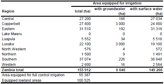
Area equipped for irrigation is 155 912 ha [ZM01]. The figures refer to year 2002. The irrigated area per region is visible in the table below and also can be downloaded as Zambia irrigation areas in PDF or Zambia irrigation areas in Excel.
The location and command area of 10 irrigation projects was derived from the FAO irrigation map for Africa [ZM02]. The total area equipped for irrigation in these schemes was 15 757 ha. The location of 14 additional schemes was digitized from an irrigation map [ZM03]. For the provinces of Copperbelt, Central Lusaka and Southern center pivot schemes could be digitized from satellite imagery [ZM04]. The satellite imagery was also used to assign the remaining irrigated area to cultivated land in large river valleys or in the surrounding of existing irrigation schemes.
Area actually irrigated was similar to area equipped for irrigation in year 2002 [ZM05]. Area irrigated with groundwater was 6 646 ha or 12 percent of the full/partial equipped irrigated area in year 2002 [ZM05], most of it located on dolomite or limestone aquifers in the copperbelt region (Jacob Burke, FAO, pers. communication). Based on this information and a geological map of the Kafue basin [ZM06], 3 000 ha AEI irrigated with groundwater were assigned to each of the provinces of Copperbelt and Lusaka and the remaining part to the rest of the country.
References
[ZM01]: Ministry of Agriculture and Cooperatives. 2002. Strategic Plan for Irrigation Development 2002 - 2006. Draft strategy paper. 33 pages.
[ZM02]: FAO. 1987 (updated in 2005). Irrigated areas in Africa. FAO, Rome, Italy.
[ZM03]: Unknown. Irrigation Projects. Map available in the AQUASTAT library.
[ZM04]: Earth Satellite Corporation, 2004. Landsat GeoCover (2000/ETM+) Edition Mosaics, tiles 071-686, 071-687, 071-692, 071-693, 071-694, 071-699, 071-700 and 071-701. Sioux Falls, USA, USGS (available at http://glcfapp.umiacs.umd.edu:8080/esdi/index.jsp).
[ZM05]: FAO. 2005. AQUASTAT country profile Zambia. FAO, Rome, Italy.
[ZM06]: Burke, J. 1994. Approaches to integrated water resource development and management. The Kafue Basin, Zambia. Natural Resources Forum 18(3), 181-192.


