![]()
![]()
![]()
A floodplain is an area of relatively low lying flat land seasonally submerged by overspill from an adjacent river, lake or swamps (Fig.1). Fringing, floodplains (Fig.2) are normal features of the longitudinal evolution of a river and are usually long and narrow directly adjacent to the main river channel. However, other larger areas of flooded plain can arise by geographic accident at any stage in the course of the river. Such areas are often extensive and diffuse and are usually associated with either ‘Central Delta’ systems, as in the Niger and Kafue Flats (Fig. 3), or genuine estuarine deltas as with the Ouémé and lower Senegal.
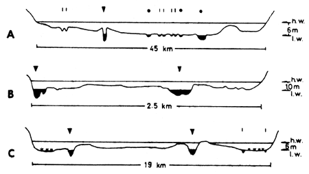
Figure 1 Cross sections of 3 river/floodplain systems (vertical scale exaggerated)
| A = Kafue (UNDP/FAO, 1968) |  | Main river channel |
| B = Niger at Onitsha (NEDECO, 1959) | Permanent swamps | |
| C = Ouémé at Zinire | Stream or secondary channel | |
| lagoon |
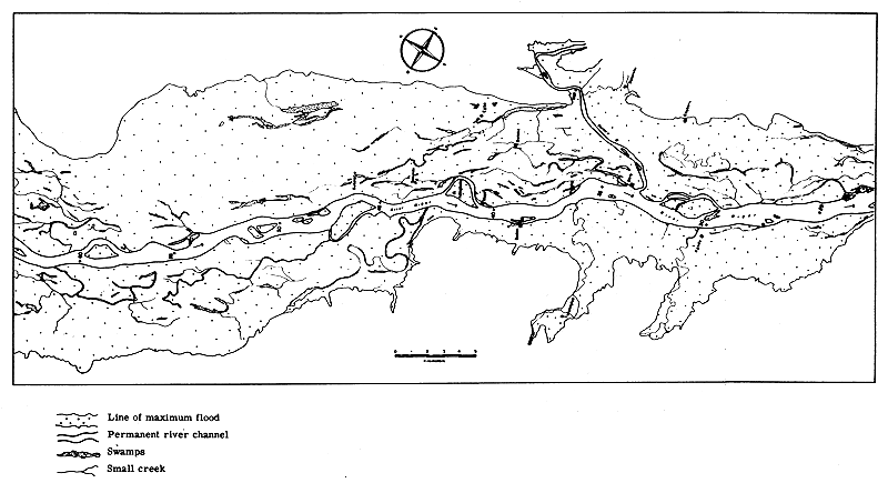
Figure 2 Reach of the Niger River (Nigeria) showing fringing floodplain with creeks, swamps and lagoons
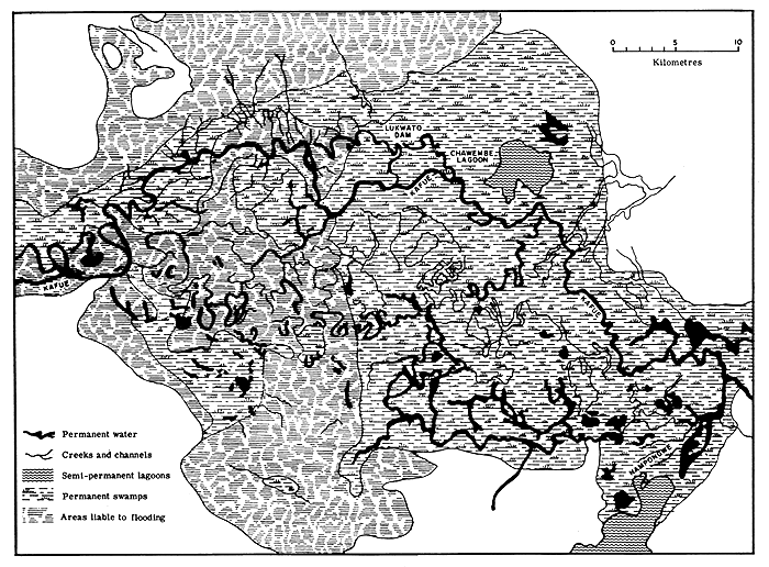
Figure 3 Portion of the Kafue flats showing creeks, channels, swamps and lagoons
According to Leopold, Wolman and Miller (1964) a typical floodplain includes the following features:
In view of these authors floodplains are depositional features of a river valley whereby sediment is temporarily stored in the floodplain. Under equilibrium conditions averaged over a number of years net inflow of sediments equals net outflow, although local changes in the morphology of the floodplain occur through silting of old channels and cutting of new ones.
Most of these major features of floodplains can be seen in larger rivers, although in smaller water courses they may be hard to distinguish due to the rapidity with which change occurs in them.
The features of the floodplain that are ecologically most important for fish are:
The main river channel, which usually retains water at all times of the year and may be either simple or braided. Braided channels (see Fig.4) consist of many anastomosing water courses meandering among sandy and vegetated islands, which are exposed at low and flooded at high water. Such channels are typical of portions of the Zambezi, Niger and Congo Rivers and where they occur the lateral floodplain is often restricted in width. There is some evidence (Svensson, 1933; Gosse, 1963) that ecologically such islands are analogous to the lateral floodplain and fulfil a similar role in the biology of the fish.
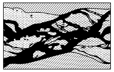
Figure 4 Braided channel, Niger River
Black = Permanent water; Hatched = Plateau
Dashed = bank
The floodplain, which is submerged during the flood phase and dries out during the low water phase. The majority of floodplains are on rivers of the “Sudanian” type, i.e., with grass savannah vegetation, although some rivers of the “Guinean” type have forested floodplains which give the flooded forest typical of many Zairian rivers.
Swamps and pools (lagoons) situated in depressions of the floodplain which may be permanent, persisting from one flood phase to the next, or temporary, drying out progressively as the low water phase advances (Figs. 2, 3, and 7). The distinction between swamps and pools depends largely on the amount of vegetation, which can alter throughout a season. There is a tendency for permanent pools to become swamps as the water level in them is lowered. In their most extreme form these features comprise a considerable portion of the floodplain area; systems such as the Luapula and Pongola consist of strings of large permanent lakes, and the Elephant marshes of the Shire River floodplain are extensive persistant swamps. Pools may form in simple depressions in the plain filling as the water extends across the surface and retaining water after the flood has subsided. Such blind pools loose water by evaporation, or if below the water table remain as permanent bodies. More complex types of pools, connected to the main river by channels or creeks are also found on some floodplains. These may form discrete systems which only interconnect at the height of the floods (Fig.7).
Channels and creeks, which connect the depressions of the floodplain with each other and with the river form a network over the plain. Some of these penetrate the levée and represent the main paths of water movement during the earlier periods of rising water and the later phases of falling water (Figs. 2 and 3).
Levées or raised banks bordering the main river channel, which may be significant in the way in which they direct or deflect the water flow over the floodplain and delay both the onset of flooding and the drainage and drying of the plain.
The importance of these features is frequently acknowledged by the peoples living on floodplain systems and is reflected in their language where each is named (Holden, 1963; Hurault, 1965; CTFT, 1972; Rzoska, 1974). For example, in the Senegal the levée is “Fondé” and the depressions of the floodplain “Oualo” are fed by channels “tiangol” and retain in their lowest part a permanent pool or marsh “Vindou”.
In addition to the basic classification (2.1) of floodplains into fringing and deltaic types based on their geomorphology further classifications have been proposed.
Svensson (1933) distinguishes three main types of floodplain swamp depending on the manner of their inundation. His type 1 swamps are formed from local precipitation or drainage only and become connected with the river or other lower lying swamps by a single channel or creek. Such swamps are never influenced by variations in river height, but fish may migrate to them by ascending the connecting channel. Type 2 areas are situated immediately alongside the river and are flooded directly by it. Swamps of the third type (type 3) are intermediate between the other two and are located in the shallow depressions of the floodplain separated from the river by levées. Access to them is by channel and flooding results in the first instance from local rainfall and drainage and only later by a rise in river level.
Floodplains may also be separated by the size and permanence of the water body with which they are associated as the dynamics of fish populations of river/floodplain systems connected with large lakes (e.g., the Yaérés of the Chari-Logone Rivers (Durand, 1970) or the floodplain of the Kenyan rivers flowing into lake Victoria) are likely to differ greatly from those of rivers that break into a series of isolated pools in the dry season, if only by virtue of the carrying capacity of the water mass available during low water (Van Someren, 1961).
Rivers, themselves, vary in nature regionally within the African continent. Daget and Iltis (1965) classify West African rivers into (i) Guinean and (ii) Sudanian types.
Guinean rivers are those which drain the forested areas of West Africa. They run their course through gallery forest and have floodplains which may extend to inundate large areas of forest floor. These are reputedly less productive than Sudanian rivers.
Sudanian rivers drain the open savannah regions and have little or no fringing forest. The floodplain is usually extensive and grass-covered.
Any absolute classification of floodplains into types based on their morphology is, however, difficult as the range of variation encompasses too many intermediate forms. It is, nevertheless, useful to bear these differences in mind when interpreting the behaviour of the different regions.
Fringing floodplains may be regarded as normal developmental features of rivers and they are present to a greater or lesser extent in most African water courses. Major floodplains arising from local geographical anomalies are somewhat rarer and are confined to only a few river systems. The flooded and dry areas of some representative floodplains are given in Table I.
TABLE I
Characteristics of some African floodplains
| Floodplain | A1 Area at peak flood (ha) | A2 Area during low water (ha) | 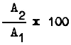 | Authority | |
| Barotse (Zambezi) | 512 000 | 32 915 | 6 | 1 | MacDonald |
| Benue* (Nigeria) | 310 000 | 129 000 | 42 | FAO/UN, 1970 | |
| Kafue flats | 434 000 | 145 560 | 34 | 1 | Kapetsky |
| Massilli* | 1 500 | 200 | 13 | 1 | Barry |
| Niger (Central Delta) | 2 000 000 | 400 000 | 20 | Konare; Raimondo | |
| Niger* (Niger) | 90 704 | 27 000 | 30 | FAO/UN, 1971 | |
| Niger* (Dahomey) | 27 440 | 3 200 | 12 | FAO/UN, 1971 | |
| Niger* (Nigeria) | 480 000 | 180 000 | 38 | FAO/UN, 1970 | |
| Okavango | 1 600 000 | 312 000 | 20 | 1 | Cross |
| Ogun* | 4 250 | 2 500 | 59 | 1 | Dada |
| Oshun* | 3 740 | 2 000 | 53 | 1 | Dada |
| Ouémé | 100 000 | 5 170 | 5 | Pers. obs. | |
| Pongolo* | 10 416 | 2 927 | 28 | 1 | Coke |
| Senegal* | 1 295 000 | 78 700 | 6 | 1 | Lessent, Fall, Sere |
| Elephant & Ndinde Marshes | |||||
| (Shire)2 | 67 300 | 46 049 | 68 | 1 | Hastings |
| Sudd (Nile) | 9 200 000 | 1 000 000 | 11 | Rzóska, 1974 | |
| Volta* (White Volta)2 | 85 324 | 10 221 | 12 | 1 | Vanderpuye |
| Yaérés (Logone)2 | 700 000 | 1 | Ali Garam |
* Fringing floodplains
1 Replies to CIFA Working Party forms
2 Part of a larger system
Less data are available on the composition of the low-water components of the system (Table II) although the figures that are shown indicate the relatively low production of the total area that is contributed by the main channel.
TABLE II
Dry season composition of floodplain systems
| Floodplain | River plus channels | Swamp | Lagoon/Lake | Total | Dry area (ha) |
| Kafue | 5 380 ( 4) | 138 000 (89) | 10 180 ( 7) | 145 560 | 288 440 |
| Shire | 724 ( 2) | 15 500 (84) | 6 000 (14) | 46 049 | 21 251 |
| Pongolo | 427 (15) | - | 2 500 (85) | 2 927 | 7 489 |
| Senegal | 28 100 (36) | - | 50 600 (64) | 78 700 | 1 216 300 |
| Ouémé | 1 402 (27) | - | 3 768 (73) | 5 170 | 94 830 |
- Negligible area
( ) Percentage of total
![]()
![]()
![]()