![]()
![]()
![]()
1. GEOGRAPHY AND CLIMATE (Welcomme, 1979a)
Uganda (with a surface area of 236 000 km2) is a high plateau dipping to the southeast to the Lake Victoria Basin. The west of the country is traversed from north to south by the western area of the Great Rift Valley. There is a high mountainous chain, the Ruwezoris, in the extreme west; to the southwest the Bufumbiro volcanoes block the Rift Valley. In the east a chain of volcanic peaks stretches north to south with Mounts Moroto, Kadem and Elgan. The rest of the plateau consists of rolling hills with extensive papyrus swamps in their valleys. There is one major barrage: Owen Falls, across the point where the White Nile leaves Lake Victoria.
Although Uganda lies astride the equator, any climatic severity is eased by its altitude. In the wettest areas along the western shore of Lake Victoria there are two rainy seasons (February-June and April-December). Although the twin season pattern also prevails over the rest of the country, the north and west are much more arid.
Uganda's population is almost entirely rural and scattered, growing staples such as plantains and corn and cash crops such as coffee, cotton and tea.
2. HYDROGRAPHY (mainly adapted from Balarin, 1985c)
In general, Uganda has an abundance of water resources covering an area of nearly 44 000 km2. This area is made up of over 36 000 km2 of open water, 5 100 km2 of swamps, and over 2 000 km of main rivers. Nearly 10 000 permanent springs with a minimum flow of 3.6 m3/hr has been recorded. The Government of Uganda (1967) also reports the existence of 4 400 boreholes (mean depth 100 m), 963 earth dams (7 m walls) or deep (5 m) ground storages for dry season water holding of 4 500 m3 for cattle and domestic use, and 3 300 ha of reclaimable swamp suitable for cultivation.
2.1 Lakes
Uganda has an extensive lake system covering over 38 500 km2. It comprises Lake Victoria and Lake Kyoga, as well as the Rift Valley Lakes (Edward, George and Albert). Lake Kyoga is, in essence, an extension of the Victoria Nile. It is relatively shallow with numerous estuaries and swamps.
2.2 Rivers, Floodplains and Swamps
Uganda lies almost wholly within the White Nile Drainage Basin flowing to the Mediterranean. About 10 regional drainage basins exist, mainly associated with the lakes (see Fig. 1). In the southern part of the country almost all watercourses draining the plateau flow into Lake Victoria and Lake Kyoga. They are characterized by broad shallow valleys, slow moving water and swamp conditions. On the Northern Plateau almost all the watercourses, including River Achwa (or Aswa), are seasonal in flow, due to the dry conditions. The higher mountains of the borders have vigorous perennial streams flowing swiftly down the slopes, in steep river valleys.
The longest river is the Victoria Nile, with a discharge of 1 100–1 700 m3/sec. By far the largest river is the Albert Nile, which carries almost all of Uganda's runoff.
Over the greater part of western and central Uganda, where upwarping of the Rift Valley has reversed river flows, old drainage courses and their tributaries are now occupied by swamps totalling 5 180 km2 (Fig. 1).
A distinction is to be made between grassy swamps (57%) and papyrus swamps (43%); the former are mainly seasonal, the latter permanent. About 6% (915 km2) of the area is considered reclaimable for cultivation. Lake Kyoga, in particular, is characterized by fringe swamps covering over 230 km2.
2.3 Reservoirs
Other than the Owen Falls hydroelectric dam across the White Nile River near its outflow from Lake Victoria, there are no major impoundments. The Owen Falls dam does not regulate the water level of Lake Victoria to any significant extent although the latter, strictly speaking, acts as a “reservoir” for the hydroelectric plant.
A great number of dams have been constructed throughout Uganda. Government of Uganda (1967) lists 963 ponds, mainly in the Ankole, Teso and Karamoja districts where dry conditions necessitate seasonal water storage. Many have been stocked with fish.
2.4 Coastal Lagoons
There are none; Uganda is landlocked.
3. FISHERY PRODUCTION/POTENTIAL
3.1 Aquaculture
Aquaculture has been applied both to the classical rearing of fish in ponds for subsistence consumption and to the extensive practice of stocking natural water bodies and reservoirs. Both have contributed substantially to fish production in Uganda.
Peak development of aquaculture occurred in 1968 when fish farming was carried out in 11 000 ponds over 410 ha, yielding 800–900 t/yr of fish. TDRI (1983) estimated production at 200 t/yr; however, latest estimates have been more radical: 30 t in 1983; 38 t in 1987 (Vincke, 1989, pers.comm.).
Aquaculture is entirely in the hands of subsistence farmers with small ponds of 100 to 400 m2.
Table 1. FISH FARMING PRODUCTION IN UGANDA, 1953–1983
(cited by Balarin, 1985c)
| Year | Production (t) | Ponds | Total area (ha) |
| 1953 | Start up - Construction Kajansi | ||
| 1959 | 5 000 | ||
| 1960 | 200–500 | ||
| 1962 | 329 | 7 270 (700 dams) | |
| 1963 | 200 | 10 000 | 400 |
| (+ 800 dams) (10% well managed) | |||
| 1965 | 670 | 11 000 (55% operational) | 410 |
| 1966 | 70–113 | 6 000–8 000 (20–25% neglected) | 290 |
| 1968 | 800–900 | 11 000 | 410 |
| 1974 | 10 000 | ||
| 1975 | 700 | ||
| 1982 | 200 | ||
| 1983 | 31 | 11 000 (25% operational) | 410 |
3.2 Fish production and per caput supply
Table 2. FISH PRODUCTION AND PER CAPUT SUPPLY - Uganda, 1970–1987
| Nominal Domestic Production (excluding exports) (t) 2 | Nominal Consumer Supply (excluding imports and exports (kg/person) | ||||||
| Year | Population '000 1 | Inland capture | Aquaculture 3 | Total | Inland capture | Aquaculture 3 | Total |
| 1970 | 9 806 | 129 000 | - 4 | 129 000 | 13.1 | - | 13.1 |
| 1971 | 10 065 | 137 000 | - | 137 000 | 13.6 | - | 13.6 |
| 1972 | 10 331 | 166 000 | - | 166 000 | 16.1 | - | 16.1 |
| 1973 | 10 604 | 169 500 | - | 169 500 | 16.0 | - | 16.0 |
| 1974 | 10 884 | 167 500 | - | 167 500 | 15.4 | - | 15.4 |
| 1975 | 11 171 | 188 000 | 700 | 188 700 | 16.9 | 0.06 | 16.9 |
| 1976 | 11 534 | 152 400 | - | 152.400 | 13.2 | - | 13.2 |
| 1977 | 11 908 | 219 220 | - | 219 220 | 18.4 | - | 18.4 |
| 1978 | 12 295 | 223 830 | - | 223 830 | 18.2 | - | 18.2 |
| 1979 | 12 694 | 179 930 | - | 179 930 | 14.2 | - | 14.3 |
| 1980 | 13 106 | 165 840 | - | 165 840 | 12.6 | - | 12.6 |
| 1981 | 13 549 | 166 590 | - | 166 590 | 12.3 | - | 12.3 |
| 1982 | 14 007 | 170 035 | 28 5 | 170 063 | 12.1 | 0.002 | 12.1 |
| 1983 | 14 481 | 172 000 6 | 30 5 | 172 030 | 11.9 | 0.002 | 11.9 |
| 1984 | 14 971 | 212 200 | 31 5 | 212 231 | 14.2 | 0.002 | 14.2 |
| 1985 | 15 477 | 160 800 | 33 5 | 160 833 | 10.4 | 0.002 | 10.4 |
| 1986 | 16 026 | 197 600 | 35 5 | 197 635 | 12.3 | 0.002 | 12.3 |
| 1987 | 16 595 | 200 000 | 38 5 | 200 038 | 12.0 | 0.002 | 12.0 |
1 Source: FAO
2 Source: FAO Fisheries Dept. FISHDAB/Govt. of Uganda
3 included in “Inland capture” if not specified
4 -: data not available
5 Vincke, 1989 (pers.comm.)
6 TDRI 1983 estimate: 78 000 t
3.3 Inland catch range and potential yield
Table 3. INLAND CATCH RANGE AND POTENTIAL YIELD - Uganda
| Water body | Period | Annual catch range (t) ** | Potential annual yield (t) ** |
| Lakes | |||
| Albert | 1983–1986 | 6 000–3 200 | 12 000–18 240 |
| Bisina* | 1960–1969 | 2000–984* | - |
| Bunyoni | - | - | - |
| Edward | 1970–1988 | 5 730–3 000 | 4 000 |
| George | 1969/70–1976 | 4 000–4 700 | 5 000 |
| Kachira | 1966 | 1 100 | - |
| Kayumba | 1969 | 7 | - |
| Kijanebalola | 1960–1966 | 500–800 | - |
| Kwania | - | - | - |
| Kyahafi | 1969 | 4.5 | - |
| Kyamwiga | - | - | - |
| Kyoga Complex | 1980–1988 | 131 000–57 000 | 65 000 |
| Mulehe | 1969 | 27.8 | - |
| Mburo | - | - | - |
| Mutanda | - | - | - |
| Nabugabo | - | - | - |
| Nakivali | 1966 | 274 | - |
| Nyabihoko | 1969 | 150 | - |
| Nyamasungiri | 1969 | 52.7 | - |
| Opeta* | - | - | - |
| Saka | 1969 | 5 | - |
| Victoria | 1983–1986 | 22 000–56 000 | 45 000 |
| Wamala | 1981–1983 | 3 800–2 000 | 4 000 |
| Rivers | |||
| Kazinga Channel | 1976 | 500 | 290 |
| Turkwell | - | - | - |
| White (Albert) Nile | 1983–1986 | 4 000–1 600 | 6 000 |
| White (Victoria) Nile | - | - | - |
| Reservoirs | |||
| Kanyanya | 1969 | 29.2 | - |
| Kigabagaba | 1969 | 10.7 | - |
| Kiziramere | 1969 | 7.7 | - |
| Rugongi | 1969 | 12.9 | - |
| Rushozi | 1969 | 15.4 | - |
* not included in total as part of the Kyoga Lakes Complex
** Sources: see text
| Total annual yield: | 95 500–214 200 t |
| Potential annual yield: | 141 290–147 530 t (not including small lakes and reservoirs) |
Table 4. TOTAL CATCH, UGANDA, 1972–1986 ('000 t)
| Water body | 1972 | 1973 | 1974 | 1975 | 1976 | 1977 | 1978 | 1979 | 1980 | 1981 | 1982 | 1983 | 1984 | 1985 | 1986 |
| Lake Victoria | 32.2 | 32.3 | 23.8 | 156.6 | 9.2 | 15.7 | 14.3 | 12.0 | 10.0 | 17.0 | 13.0 | 17.0 | 44.8 | 45.6 | 56.0 |
| Lake Albert | 19.4 | 13.0 | 13.0 | 19.1 | 9.1 | 20.6 | 20.6 | 17.0 | 13.0 | 6.0 | 10.0 | 4.0 | 4.0 | 6.0 | 3.2 |
| Albert Nile | 4.1 | 4.2 | 3.0 | 7.2 | 3.3 | 1.8 | 5.7 | 4.5 | 3.2 | 3.0 | 1.0 | 4.0 | 1.9 | 1.6 | 1.6 |
| Lake Kyoga | 90.3 | 100.5 | 104.0 | 121.1 | 114.0 | 167.0 | 167.0 | 131.0 | 131.0 | 130.0 | 138.0 | 140.0 | 150.0 | 100.0 | 128.0 |
| Lakes Edward/George Kazinga Channel | 11.7 | 11.0 | 10.0 | 13.6 | 9.0 | 12.1 | 11.8 | 9.6 | 7.0 | 5.0 | 6.9 | 6.0 | 10.4 | 6.6 | 8.0 |
| Lake Wamala | 3.9 | 4.3 | 6.0 | 6.5 | 4.0 | 1.1 | 1.8 | 2.0 | 1.0 | 3.8 | - | - | - | - | - |
| Other waters | 3.8 | 4.0 | 8.2 | 4.7 | 3.3 | 1.2 | 1.1 | 1.8 | 0.7 | 3.0 | 1.1 | 1.3 | 1.2 | 1.0 | 0.8 |
| Total | 166.0 | 169.5 | 167.0 | 188.0 | 152.0 | 219.5 | 223.3 | 179.9 | 165.9 | 167.8 | 170.0 | 172.3 | 212.3 | 160.8 | 197.6 |
Source: Fisheries Department, Entebbe, Govt. of Uganda, cited in TDRI 1983 (1972 to 1981) Statistisches Bundesamt Länderbericht Uganda 1988 (1982 to 1986)
TDRI ESTIMATES FOR 1983
(TDRI, 1983)
| Fishery | Annual prod. (t) | Potential prod. (t) |
| Lake Albert | 6 000 | 12 000 |
| Lakes Edward/George | 6 500 | 11 000 |
| Lake Kyoga | 35 000 | 65 000 |
| Lake Victoria | 22 000 | 45 000 |
| Lake Wamala | 2 000 | 4 000 |
| Albert Nile | 4 000 | 6 000 |
| Minor waters | 2 000 | 4 000 |
| Aquaculture | 200 | 3 000 |
| Total | 77700 | 147 000 |
4. STATE OF THE FISHERY
4.1 Yield (after Balarin, 1985c)
Official statistics (Tables 2, 4) show a steady rise in overall landings to a peak of 232 000 t in 1978, falling to 172 000 t in 1983. Lake Kyoga provided from 54 to 79% of the catch.
It is also reported that 15 000 canoes, averaging four fishermen per canoe, support at least 40 000 families. Government figures even suggest the existence of 20 000 fishermen dependent on lake and river fisheries - about 100 000 or more families.
TDRI (1983) re-examined the statistics and considers the 1982 catch to average only 78 000 t. A significant source of error was considered to be the Lake Kyoga statistics (estimated to be exaggerated by 91 000 t). Reduction in the individual size of the Nile perch emphasized overfishing. Considering that efforts to rehabilitate the fisheries will increase production, and assuming the development of a recently established Nile perch fishery in Lake Victoria, target yields were set at 147 000 t. It is of interest to note that Nile perch stocked into Lake Kyoga in 1954 now yields over half of the catch (FAO, 1982b). Lake Victoria, stocked in 1960, now yields 30% of the catch (TDRI, 1983).
It is likely that the Nile perch fishery has developed at the expense of the smaller species stocks and therefore the potential might more closely approximate the lower yield targets of 147 000 t/yr. However, the fishery in Uganda has not been examined critically for some time and there is an urgent need for an updated stock assessment.
4.2 Factors influencing yield
All the major fisheries have extensively declined over the past decade, but there is no reliable data to develop an accurate status of the situation. TDRI (1983) indicates substantial reduction in net size and number, and a decrease in motorized boats. Statistics in the 1970's showed 20–25 nets per canoe on Lake Kyoga, but this is now reduced to only seven. Reduced catch has meant that a large portion of the fishermen are now also engaged in agriculture (Balarin, 1985c).
The Lake Victoria potential yield figure has been inflated by TDRI (1983) in anticipation of continued high production of Nile perch over the next few years; after a period of some years (possibly as short as 5–10 years) production is anticipated to fall off to around 35 000 t (TRDI, 1983).
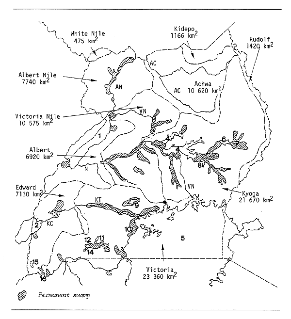
| LAKES | RIVERS | |||||
| 1 | Albert (Mobutu Sese Seko) | 9 | Kamala | AC | Achwa River | |
| 2 | Edward (Idi Amin Dada) | 10 | Nabugabo | AN | Albert Nile (White Nile) | |
| 3 | George | 11 | Kachira | KC | Kazinga Channel | |
| 4 | Kyoga/Kwania | 12 | Mburo | KG | Kagera River | |
| 5 | Victoria | 13 | Kinjanebalala | KT | Katonga River | |
| 6 | Bisina (Salisbury) | 14 | Nakivali | VN | Victoria Nile (White Nile) | |
| 7 | Opeta | 15 | Mutanda | |||
| 8 | Nakuwa | 16 | Bunyoni | |||
Fig. 1. LAKES, RIVER BASINS, SWAMPS AND RIVERS OF UGANDA
(after Balarin, 1985c)
4.3 Future development possibilities (after TDRI, 1983)
While it is accepted that production can be increased by inputs of gear and engines, TDRI (1983) do not consider it realistic to expect a return to the very high production level of 223 000 t recorded in the official statistics for 1978. To obtain the recommended yield proposed will demand the capability to monitor and manage the fisheries. Many of the fisheries will soon become heavily exploited, and heavy overfishing could lead to a serious loss of production that would take many years to recover.
5. KEY BIBLIOGRAPHY
Balarin, 1985c
6. WATER BODIES DIRECTORY
| Lakes | ||
| Albert (Mobutu) | Kijanebalola | Nabugabo |
| Bisin A (Salisbury) | Kwania | Nakivali |
| Bunyoni | Kyahafi | Nyabihoko |
| Edward (Idi Amin) | Kyamwiga | Nyamusingire |
| George | Kyoga Lakes Complex | Opeta |
| Kachira | Mulehe | Saka |
| Katwe | Mburo | Victoria |
| Kayumba | Mutanda | Wamala |
| Volcanic Crater Lakes of Western Uganda | ||
| Rivers | ||
| Kagera | Semliki | White Nile |
| Kazinga Channel | Turkwel | |
| Reservoirs | ||
| Kanyanya | Kiziramere | Rushozi |
| Kigabagaba | Rugongi | |
LAKE ALBERT (= MOBUTU)
(International water)
| Geographical data (see Fig. 2) | |
| Location: | Uganda, Zaire - 1° 9'–2° 17'N; 30° 25'–31° 25'E |
| Altitude: | 618 m |
| Surface area: | 5 270 km2 total; Uganda: 2 850 km2 (54%); Zaire: 2 420 km2 (46%) |
| Depth: | 58 m (max); 25 m (mean) |
| Volume: | 140 km3 total; 80 km3 in Uganda |
| Max. length: | 160 km |
| Max. width: | 35 km |
| Major inflowing rivers: | Semliki, Victoria Nile |
| Outflowing rivers: | Albert Nile (Uganda) |
| Physical and chemical data | |
| Conductivity: | K20 675–730 μ S/cm |
| Surface temperature: | 26–29°C |
| pH: | 8.4–9.5 |
| Oxygen: | rich in oxygen at all depths |
| Dissolved solids (mg/l): | |
| 565 (mean); 518–672 (Lake); 370–680 (Semliki Delta) | |
| Ionic composition: | (Van Der Ben, 1959) | (Talling & Talling, 1965) | ||
| mg/l | mg/l | |||
| Na | 97.0 | 91.0 | ||
| K | 66.0 | 65.0 | ||
| Ca | 9.8 | 9.8 | ||
| Mg | 31.5 | 32.1 | ||
| HCO3+CO3 | 475.8 | 445.3 | ||
| Cl | 31.0 | 31.0 | ||
| SO4 | 25.0 | 32.0 | ||
| SiO4 | 3.4 | 0.09–0.9 | ||
| μg/l | μg/l | |||
| NO3-N | 9.0 | - | ||
| PO4-P | 130.0 | - | ||
| Total P | - | 200.0 |
| Fisheries data | |
| No. of fish species: | 46 (Greenwood, 1964) |
| Main catches: | 75 to 85% of catches are: |
| Characidae: | Alestes baremose, Hydrocynus forskahli |
| Centropomidae: | Lates niloticus albertianus (Proude, 1984) |
| No. of boats: | In Uganda: |
| 860 in 1970 | |
| 1 300 in 1983 | |
| Total catch: In Uganda: | |
| Year | Tons | |
| 1955 | 3 800 | |
| 1957 | 9 000 | |
| 1960 | 12 311 | |
| 1961 | 11 878 | |
| 1962 | 11 000 | |
| 1963 | 10 268 | |
| 1964 | 10 042 | |
| 1965 | 12 032 | |
| 1966* | 13 382 | (including Semliki River and Albert Nile) |
| 1967 | 12 981 | (including Semliki River and Albert Nile) |
| 1968 | 12 000 | |
| 1969 | 7 449 | |
| 1970 | 9 530 | |
| 1971 | 9 500 | |
| 1972 | 19 400 | |
| 1973 | 13 000 | |
| 1974 | 13 000 | |
| 1975 | 19 100 | |
| 1976 | 9 100 | |
| 1977 | 20 600 | |
| 1978 | 20 600 | |
| 1979 | 17 000 | |
| 1980 | 13 000 | |
| 1981 | 6 000 | |
| 1982** | 10 000 | |
| 1983 | 4 000 | |
| 1984 | 4 000 | |
| 1985 | 6 000 | |
| 1986 | 3 200 | |
| 1987*** | 15 000 | (estimate for entire lake) |
Sources :
* 1966–81: Fisheries Department, Entebbe, Govt. of Uganda, cited in TDRI, 1983
** 1982–86: Statist. Bundesamt Länderbericht Uganda, 1988
*** Giudicelli et al., 1987
| Potential annual yield: | ||
| in Uganda: | 18 240 t (64 kg/ha - Giudicelli et al., 1987) | |
| in Uganda: | 12 000 t (42 kg/ha - TDRI, 1983) | |
| total lake: | 25 000 t (47 kg/ha - Proude, 1984) | |
| (13 500 t in Uganda; 11 500 t in Zaire) | ||
| total lake: | 34 000 t (64 kg/ha - Giudicelli et al., 1987) | |
| Key reference for Lake Albert (Mobutu): Proude, 1984 | ||
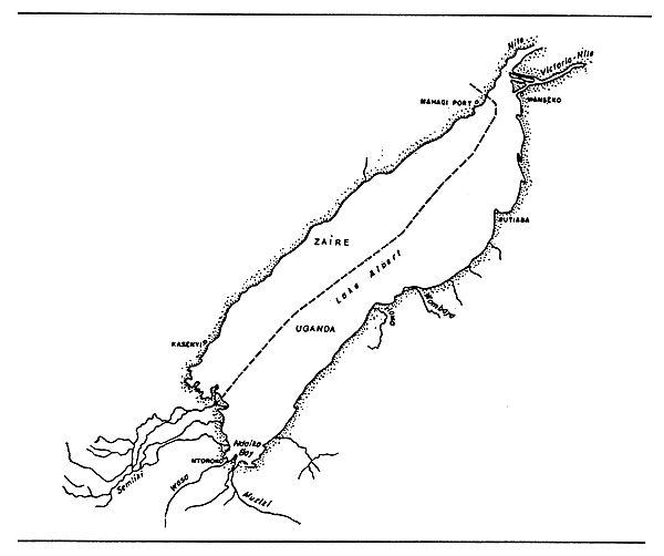
Fig. 2. LAKE ALBERT/MOBUTU
(after Welcomme, 1972)
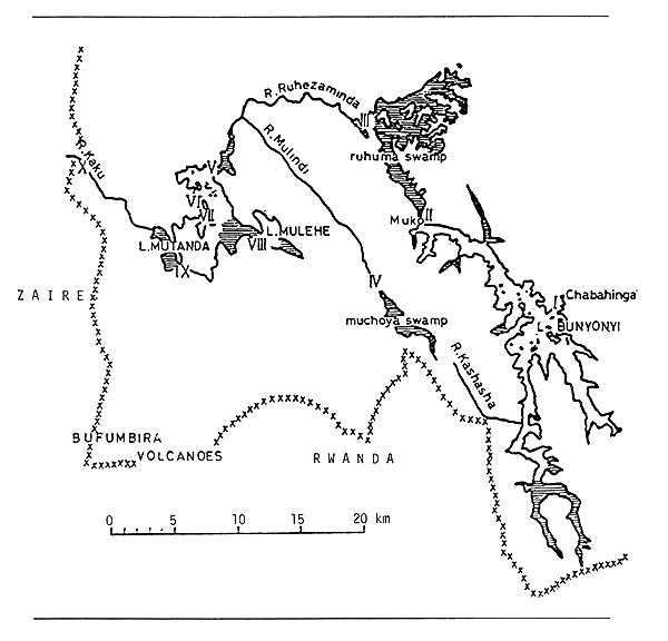
Fig. 3. LAKE AND RIVER SYSTEM IN S.W. KIGEZI
(after Visser, 1962)
LAKE BISINA (= SALISBURY)
| Geographical Data | |
| Location: | Uganda - 1°38'N; 33°57'E |
| Max. length: | 30 km |
| Max. width: | 11 km (mean: 7 km) |
| Surface area: | circa 150 km2 |
| Inflowing river: | Lochomon |
| Special features: | Part of Kyoga Lakes complex |
| Physical and chemical data (Talling & Talling, 1965) | |
| Conductivity: | 365 μ S/cm |
| Fisheries data | |
| Total annual catch: | 2 000 t in 1960; 984 t in 1969 |
LAKE BUNYONI
| Geographical data: | |
| Location: | Uganda - 1°18'S; 29°54'E (see Figs. 1, 3) |
| Altitude: | 1 973 m |
| Surface area: | 57 km2 (Welcomme, 1972) |
| Depth: | 39.3 m (max) |
| Max. length: | 24 km |
| Outflowing river: | Ruhuma |
| Special features: | The Ruhuma River, into which Lake Bunyoni discharges, goes into the Ruhuma Swamps (90 km2), a wide swampy valley with papyrus as main vegetation (Visser, 1962). |
| Physical and chemical data | |
| Conductivity: | 99–135 μ S/cm (EAFRO, 1954) |
| 260–262 μ S/cm (Talling & Talling, 1965) | |
| 275–300 μ S/cm (Visser, 1962) | |
| Surface temperature: | 21–22°C |
| pH: | 7.0–7.2 (EAFRO, 1954) |
| 8.0–9.3 (Talling & Talling, 1965) | |
| 7.7–7.8 (Visser, 1962) | |
| Alkalinity: | N × 10-4 12–19.8 (EAFRO, 1954) |
| Ionic composition: | |
| (EAFRO, 1954) | (Tall. & Tall., 1965) | (Visser, 1962) | |
| mg/l | mg/l | mg/l | |
| Na | - | - | 6.1 |
| K | - | - | 7.5 |
| Ca | 11.3–19.2 | 11.3 | 13.0 |
| HCO3+CO3 | - | 73.2 | - |
| Cl | 6.0–18.0 | 6.0 | 2.2 |
| SiO2 | 2–4 | 2 | - |
| NO2-N | 0.03 | - | - |
| NO3 | - | - | 1.07 |
LAKE EDWARD (= IDI AMIN)
(International water)
| Geographical data (see Fig. 4) | |||
| Location: | Uganda, Zaire - 0°04'–0°39'S; 29°20'–30°E | ||
| Altitude: | 914 m | ||
| Surface area: | Uganda: 670 km2 (29%); Zaire: 1 630 km2 (71%) | ||
| Total: 2 300 km2 | |||
| Depth: | 117 m (max); 34 m (mean) | ||
| Volume: | 78.2 km3 - 90 km3 | ||
| Max. length: | 90 km | ||
| Max. width: | 40 km | ||
| Major inflowing rivers: | Rutshuru (also connected to Lake George by the Kasinga Channel), Rwindi, Luholu, Ishasha | ||
| Outflowing river: | Semliki | ||
| Physical and chemical data | |||
| Conductivity: | K20 900 μ S/cm (EAFRO, 1954); | ||
| 925 μ S/cm (Talling & Talling, 1965) | |||
| Surface temperature: | Circa 26°C | ||
| Dissolved solids: | 521 mg/l | ||
| pH: | 8.5–9.3 | ||
| Ionic composition: | (Talling & Talling, 1965) | ||
| mg/l | |||
| Na | 110.0 | ||
| K | 9.0 | ||
| Ca | 12.4 | ||
| Mg | 47.3 | ||
| HCO3+CO3 | 600.0 | ||
| Cl | 36.0 | ||
| SO4 | 31.0 | ||
| SiO2 | 6.5 | ||
| μg/l | |||
| NO3-N | 24.0 | ||
| PO4-P | 18.0 | ||
| Total P | 127.0 | ||
| Fisheries data | ||||
| No. of fish species: | 53, of which 28 are cichlids (Greenwood, 1964) | |||
| Main catches: | (Jensen et al., 1983; and Vakily, 1989) | |||
| Tilapia | (Oreochromis niloticus eduardianus) | 60–70% | ||
| Bagrus | (Bagrus docmak) | 10% | ||
| Barbus | (Barbus altianalis eduardianus) | 5% | ||
| Protopterus | (Protopterus aethiopicus aethiopicus) | 10% | ||
| Clarias | (Clarias gariepinus) | 10% | ||
| No. of boats: | in Zaire: | 700 canoes in 1988 (Vakily, 1989); | ||
| in Uganda | (including Lake George): 878 in 1982 (TDRI, 1983) | |||
| Total catch: | in Uganda | |||
Miscellaneous sources
(Note: Due to the variety of sources and methods used, these
estimates do not necessarily reflect the actual catches.)
| Year | Tons |
| 1955 | 2 500 |
| 1957 | 7 000* |
| 1960 | 5 162 |
| 1961 | 6 342 |
| 1962 | 6 751 |
| 1963 | 6 464 |
| 1964 | 5 829 |
| 1965 | 7 846 |
| 1966 | 7 890 |
| 1967 | |
| 1968 | 12 808* |
| 1969 | 11 826* |
| 1970 | 5 700 |
| 1971 | 8 100 |
| 1972 | 7 000 |
| 1973 | 7 100 |
| 1974 | 6 600 |
| 1975 | 8 400 |
| 1976 | 7 700 |
* includes Lake George and Kazinga Channel
Definite sources (in tons)
| Author | Year | Zaire | Uganda | Total Lake |
| Dunn, 1989 | 1961 to 1988 | - | 5 564 ± 2 265 | - |
| (average) | ||||
| Dunn, 1989 | present | - | ±4 000 | - |
| Giudicelli et al., 1987 | 1985 | - | - | 10 400 |
| TDRI, 1983 | 1983 | - | 6 500* | - |
| Vakily, 1989 | 1988 | 10–11 000 | 3 000 | 14 000 |
| Welcomme, 1972 | 1969–1970 | 10 351 | 5 731 | 16 082 |
| Welcomme, 1979a | - | 5 000 | - | - |
| See Table 4 | 1972 to 1986 | - | see Table 4* | - |
* includes Lake George and Kazinga Channel
Potential annual yield: (in tons)
| Author | Zaire | Uganda | Total Lake |
| Jensen et al., 1983 | 15–20 000 | - | - |
| Giudicelli et al., 1987 | - | - | 13 000 |
| Vakily, 1989 | - | - | 15–16 000 |
| TDRI, 1983 | - | 11 000* | - |
| Dunn, 1989 | 10 000 | 4 000 | 14 000 |
* includes Lake George and Kazinga Channel
Key reference: for Lake Edward: Vakily, 1989
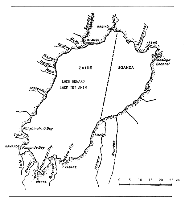
Fig. 4. LAKE EDWARD/IDI AMIN
(after Welcomme, 1972)
LAKE GEORGE
| Geographical data (Welcomme, 1972) | |
| Location: | Uganda - 0°05'N–0°05'S; 30°02'–30°18'E |
| Altitude: | 914 m |
| Surface area: | 250 km2 |
| Depth: | 7 m (max); 2.4 m (mean) |
| Volume: | 0.5 km3 |
| Max. length: | 23 km |
| Max. width: | 18 km |
| Outflowing river: | Kasinga Channel to Lake Edward |
| Catchment area: | 9 000 km2 |
| Outflow: | 53.5 m3 s-1 |
| Physical and chemical data | |
| Conductivity: | K20 165 (EAFRO, 1954) - 207 (Beadle, 1932) μ S/cm |
| 210 μ S/cm (in wet season of October 1967) to | |
| 235 μ S/cm (in dry season of July 1967) (Viner, 1969) | |
| Surface temperature: | 25–35°C |
| Dissolved solids: | 264 mg/l (Hurst, 1925) |
| pH: | 8.5–9.5 (Dunn et al., 1969) |
| Oxygen: | Surface waters: 250% saturation during day below saturation during night Bottom waters: below saturation (Burgis, 1987) |
| Ionic composition: | (from Viner, 1969) |
| Wet season | Dry season | |
| July 1967 | Oct. 1967 | |
| meq/l | meq/l | |
| Na | 0.89 | 0.85 |
| K | 0.114 | 0.097 |
| Mg | 0.6 | 0.64 |
| Ca | 0.722 | 1.0 |
| HCO3 | 1.25 | 2.0 |
| Cl | 0.215 | 0.26 |
| SO4 | 0.375 | 0.3 |
| Mn μg/l | 40.0 | 20.0 |
| Fe (Total) μg/l | 520 | 332 |
| SiO2 mg/l | 20.5 | 20.0 |
| Nitrogen: | ||
| (total) mg/l | 2.4 | 2.7 |
| NO2 | 0 | 0 |
| NO3 μg/l | 0 | 28.4 |
| NH4 + μg/l | 51 | 0 |
| Phosphorous: | ||
| total PO4-P μg/l | 200 | 240 |
| soluble PO4-P μg/l | 42 | 18.5 |
| Photosynthetic production: (cited in Beadle, 1981) | |
| Chlorophyll a in euphotic zone: 70–280 mg/m2 | |
| Photosynthetic (gross): 5.4 gC/m2.day; 1 980 gC/m2.year | |
| Fisheries data | |
| No. of boats: | 878 canoes in 1982 (including Ugandan waters of Lake Edward) (TDRI, 1983) |
Total catch:
| Year | Tons | |
| Miscellaneous sources | ||
| 1955 | 3 500 | |
| 1957 | 7 000* | |
| 1960 | 5 021 | |
| 1961 | 4 175 | |
| 1962 | 5 133 | |
| 1963 | 4 517 | |
| 1964 | 4 245 | |
| 1965 | 4 697 | |
| 1966 | 3 250 | |
| 1967 | 2 438 | |
| 1968 | 12 808* | |
| 1969 | 3 950 | |
| 1970 | 4 242 | |
| 1971 | 2 800 | |
| 1972 | 4 300 | |
| 1973 | 2 800 | |
| 1974 | 3 200 | |
| 1975 | 4 400 | |
| 1976 | 4 700 | |
| Definite sources | ||
| 1967 | 2 438 | (Welcomme, 1972) |
| 1969 | 3 950 | (Welcomme, 1972) |
| 1970 | 4 242 | (Welcomme, 1972) |
| 1972–1986 | see Table 4 | |
| 1983 | 6 500* | |
| 1950–88** | 3 171 ± 1 093 | (standard deviation) (Dunn, 1989) |
| 1989 | 5 000 | (Dunn, 1989) |
* includes Lake Edward and Kazinga Channel
** average yield, 39-year period
Potential annual yield
| TDRI, 1983: | 11 000 t* | (±116 kg/ha) |
| Kerr, 1966: | 5 000 t | |
| Dunn, 1989: | 5 000 t |
* includes Lake Edward and Kazinga Channel
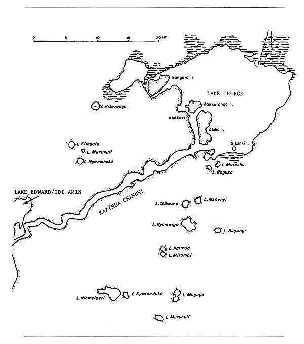
Fig. 5. LAKE GEORGE AND THE SURROUNDING CRATER LAKES
(Welcomme, 1972)
LAKE KACHIRA
| Geographical data: | |
| Location: | Uganda - 0°35'S; 31°07'E |
| Altitude: | 1 230 m (Worthington, 1932) |
| Surface area: | 36.3 km2 (Worthington, 1932) |
| Depth: | 4.1 m (max) (Worthington, 1932) |
| Max. length: | 20.0 km (Welcomme, 1972) |
| Max. width: | 3.5 km (Welcomme, 1972) |
| Outflowing river: | Kibali discharging, via the Kagera River, into Lake Victoria |
| Special features: | part of a complex of lakes (Kachira, Kijanebalola, Nakivali, Mburo, etc.) and extensive papyrus swamp (Burgis et al., 1987). The sizes and shapes of the lakes themselves vary from year to year (Worthington, 1932). (See Figs. 1, 6.) |
| Physical and chemical data (Worthington, 1932) | ||
| Temperature: | 25–26°C | |
| pH: | 8–8.4 | |
| Fisheries data | ||
| Fish species: | indigenous in 1932: Clarias spp., Haplochromis spp. introduced: various species of tilapia (Worthington, 1932) | |
| Total catch: | ||
| Year | Tons | |
| 1960 | 1 014 | |
| 1961 | 1 000 | |
| 1962 | 1 000 | |
| 1963 | 1 000 | |
| 1964 | 1 086 | |
| 1965 | 1 100 | |
| 1966 | 1 100 | |
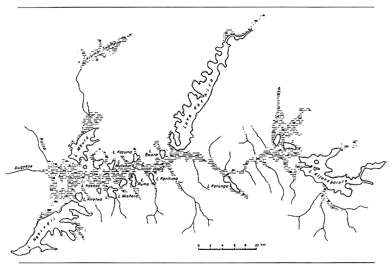
Fig. 6. THE ANKOKE AND KOKI LAKES OF UGANDA
(Welcomme, 1972)
LAKE KATWE
| Geographical data | ||
| Location: | Uganda - 0°08'S; 29°52'E | |
| Altitude: | 895 m | |
| Surface area: | 2.45 km2 (Melack, 1978) | |
| Depth: | 0.33 m (max) (Melack, 1978) | |
| Max. length: | 2.5 km | |
| Max. width: | 1.5 km | |
| Special features: | shallow and concentrated saline crater lake. Sodium chloride is dominant and the lake has long been the centre of trade in salt, which is evaporated in pans along the shore. The salt has a distinctive pink colour. (Burgis, 1987) | |
| Physical and chemical data (Melack, 1978) | ||
| Conductivity: | K20 116 000–166 000 μ S/cm | |
| Temperature: | 29.6° C | |
| pH: | 9.7 | |
| Ionic composition: | ||
| HCO3+CO3 | 1 544–2 400 meq/l | |
| SiO2 | 6.4 mg/l | |
LAKE KAYUMBA
| Geographical Data | |
| Location: | Uganda - 1°20'S; 29°47'E |
| Max. length: | 2 km |
| Max. width: | 1 km |
| Fisheries data | |
| No. of fishermen: | 6 in 1969 |
| Total catch: | 7 t in 1969 |
LAKE KIJANEBALOLA
| Geographical data | ||
| Location: | Uganda - 0° 42'S; 31°18'E | |
| Altitude: | 1 226 m (Worthington, 1932) | |
| Surface area: | 42 km2 | |
| Depth: | 4.8 m (max) (Worthington, 1932) | |
| Max. length: | 30 km | |
| Max. width: | 2 km | |
| Outflowing river: | Kibali discharging, via the Kagera River, into Lake Victoria. Overflow into the Kibali River happens about every 12 years (Worthington, 1932) and between such times the lake has no outlet. | |
| Special features: | part of a complex of lakes (Kachira, Kijanebalola, Nakivali, Mburo, etc.) and extensive papyrus swamp (Burgis, et al., 1987). The sizes and shapes of the lakes themselves vary from year to year (Worthington, 1932). (See Figs. 1, 6.) | |
| Physical and chemical data (Worthington, 1932) | ||
| Temperature: | 23.3–24.8°C | |
| pH: | 8.3 | |
| Fisheries data | ||
| Fish species: | ||
| Main catches: | Haplochromis spp.; also Clarias, Protopterus, Oreochromis niloticus, O. esculentus, O. variabilis (Okaronen, 1975b) | |
| Total annual catch and effort: | ||
| Years | Tons | |
| 1960 to 1962 | 500 | |
| 1963 to 1966 | 800 | |
LAKE KWANIA
| Geographical data (mainly cited in Burgis et al., 1987) | |
| Location: | Uganda - 1°36'-56'N; 32°32'E (See Fig. 7) |
| Altitude: | 1 033 m |
| Surface area: | 508 km2 |
| Depth: | 5.3 m (max); 4 m (mean) |
| Max. length: | 69 km |
| Max. width: | 5 to 8 km |
| Outflowing river: | 20-km-long channel to Victoria Nile River |
| Special features: | part of Kyoga Lakes complex |
LAKE KYAHAFI
| Geographical Data | |
| Location: | Uganda |
| Fisheries data | |
| No. of fishermen: | 4 in 1969 |
| Total annual catch: | 4.5 t in 1969 |
LAKE KYAMWIGA
| Geographical Data | |
| Location: | Uganda - 0°11'S; 30°08'E |
| Surface area: | 2.6 km2 |
| Max. length: | 2.5 km |
| Max. width: | 1.5 km |
KYOGA LAKES COMPLEX
| Geographical data | |||
| Location: | Uganda - 1°–2°N; 32°20'–34°20'E (see Fig. 7) | ||
| Altitude: | 1 033 m | ||
| Surface area: | 2 700 km2 (but varies with time) | ||
| 4 735 km2 of the Lake Kyoga catchment consists of swamps and lakes made up as follows: (Burgis, et al., 1987) | |||
| Area | |||
| Lakes | (km2) | ||
| Kwania | 508.1 | ||
| Kyoga | 1 821.6 | ||
| Nakuwa | 93.1 | ||
| other small lakes | 200.0 | ||
| Total | 2 622.8 | ||
| Swamps | |||
| Sezibwa | 467.5 | ||
| Naigombwa, Umpologoma and Manafwa | 528.8 | ||
| Lwere | 29.4 | ||
| Small lakes & swamps | 404.4 | ||
| Swamps of Lakes Kwania & Kyoga | 386.3 | ||
| Swamps between Olya and Lake Kwania | 136.9 | ||
| Swamps of Lake Victoria catchment | 141.3 | ||
| Total | 2 094.6 | ||
| Depth: | 10 m (max); 2.26 m (mean) in Lake Kyoga, 1987/88 (Marriott et al., 1988) | ||
| Max. length: | Lake Kyoga - 90 km (varies with time) | ||
| Max. width: | Lake Kyoga - 15 km (varies with time) | ||
| Major inflowing river: White (Victoria) Nile | |||
| Outflowing river: White (Victoria) Nile | |||
| Special features: | During years of high water level (i.e. 1965–71) the entire Kyoga complex becomes a confluent sheet of water; during years of low water (i.e. 1983) the complex breaks up into numerous distinct lakes. The largest are Lakes Kyoga and Kwania. Smaller lakes include Lakes Bisina (= Salisbury), Opeta, Nyaguo, Nyasala, Adois, Kadika, Kondo, Namasajeti, Naragaga, Nabigaga, Nawampasa, Nakuwa, Kawi and Lemwa. | ||
| Physical and chemical data - Lake Kyoga | |
| Conductivity: | K20 (in 1988): 90 to 200 μS/cm, mean 128 μS/cm (Marriott et al., 1988) |
| Surface temperature: | ± 28.0°C |
| pH: | 7.6–9.0 |
| Ionic composition: | (EAFRO, 1954) | (HYDROMET, 1974) | ||
| mg/l | mg/l | |||
| Na | 10.8 | 26.3 | ||
| K | 9.6 | 6.6 | ||
| Ca | 21.7 | 14.1 | ||
| Mg | 13.8 | 7.5 | ||
| HCO3+CO3 | 133.0 | |||
| Cl | 12.0 | 8.7 | ||
| SO4 | 31 | 2.9 | ||
| SiO2 | 34 | |||
| μg/l | ||||
| NO2-N | 22 | |||
| PO4-P | 220 | |||
| Total P | 272 |
| Fisheries data | |
| Fish species: | (cited from Marriott et al., 1988) Worthington (1929) reported 46 fish species, the majority of which occurred also in Lake Victoria. In order of economic importance, these are: Oreochromis variabilis, O. esculentus, Bagrus docmac, Clarias mossambicus, Protopterus aethiopicus, Barbus altianalis, Schilbe mystus. Also abundant: Lates victorianus and numerous species of Haplochromines. |
The introduction of Oreochromis niloticus and Lates niloticus (among others) between 1954 and 1957 produced the decline of most of the indigenous fish population. By 1969, these two introduced fishes comprised more than 80% of the total commercial catch.
The Kyoga fishery appears to have been most productive in the 1970's. A decline in the catch from the lake was noted in the early 1980's and by 1985 L. niloticus constituted less than 20% of the total commercial output. O. niloticus had become the single dominant species in the fishery. It has been suggested that the use of seines in the shallow waters of Kyoga is partly responsible for the decline of the Nile perch.
| No. of boats: | (canoes) |
| 2 200 (1961) | |
| 2 121 (1969) | |
| 4 371 (1970) (Fisheries Dept. Survey) | |
| 7 000 (1983) (TDRI, 1983) | |
| 3 459 ± 654 at 95% confidence (1987) (Marriott et al., 1988) | |
| No. of nets: | 40 000 (Marriott et al., 1988) |
Total annual catch:
| Miscellaneous sources | |
| Year | Tons |
| 1955 | 3 000 |
| 1956 | 4 500 |
| 1957 | 5 000 |
| 1960 | 13 210 |
| 1961 | 12 866 |
| 1962 | 13 813 |
| 1963 | 16 755 |
| 1964 | 18 261 |
| 1965 | 18 018 |
| 1966 | 19 577 |
| 1967 | 25 905 |
| 1968 | 32 580 |
| 1969 | 48 900* |
| 1970 | 62 100** |
| 1971 | 89 700 |
* (Welcomme, 1972)
** includes White (Victoria) Nile River
| Definite sources | |
| 1972–1986: | see Table 4 |
| 1969–1988: | see Fig. 8 |
| 1983 | 35 000 t (TDRI, 1983) |
| 1988 | 57 000 t (Marriott et al., 1988) |
Potential annual yield: Lake Kyoga Complex: 65 000 t (TDRI, 1983)
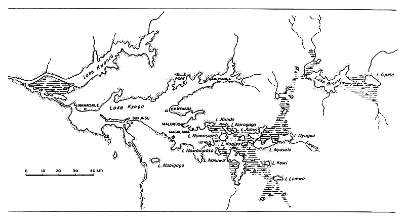
Fig. 7. LAKES OF THE KYOGA SYSTEM
(after Welcomme, 1972)
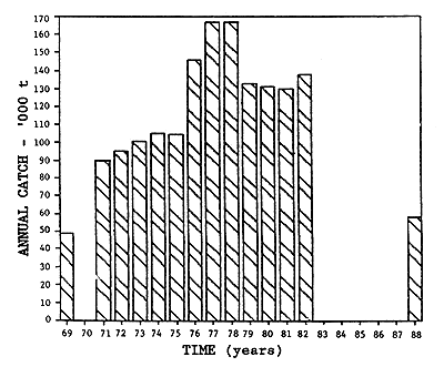
1969 catch data from Welcomme (1972)
1971–81 catch data from Fisheries Dept. figures
1988 catch data from ADP Survey estimates
Fig. 8. KYOGA LAKES COMPLEX CATCH, 1969–1988
(Marriott et al., 1988)
LAKE MULEHE
| Geographical data | (* data from Burgis, 1987) | |
| Location: | Uganda - 1°13'S; 29°43'E (see Fig. 3) | |
| Altitude: | 1 750 m* | |
| Surface area: | 5 km2* | |
| Depth: | 7.5 m (max)* | |
| Outflow: | discharges to Lake Mutanda via a papyrus swamp* | |
| Physical and chemical data | ||
| Temperature: | circa 20°C | (Burgis, 1987) |
| Conductivity: | 260 μ S/cm | (Talling & Talling, 1965) |
| 275 μ S/cm | (Visser, 1962) | |
| pH: | 7.4–8.0 | (Talling & Talling, 1965) |
| 7.3 | (Visser, 1962) | |
Ionic composition: (Talling & Talling, 1965)
| mg/l | ||
| Na | 10.8 | |
| K | 9.6 | |
| Ca | 20.8–21.7 | |
| Mg | 13–13.8 | |
| Cl | 12.0–14.2 | |
| SO4 | 21–27 | |
| SiO2 | 19.5–34 | |
| HCO3+CO3 | 2.10–2.18 | meq/l |
| μg/l | ||
| NO3-N | 22 | |
| PO4-P | 220–228 | |
| Total P | 240–272 |
Fisheries data
No. of fishermen: 33 in 1969
Total annual catch: 27.76 t in 1969
LAKE MBURO
| Geographical Data | |
| Location: | Uganda - 0°40'S; 30°56'E (see Fig. 6) |
| Altitude: | 1 230 m (Worthington, 1932) |
| Surface area: | 10.4 km2 (Worthington, 1932) |
| Max. length: | 6 km |
| Max. width: | 3 km |
| Inflowing river: | Rinzi |
| Outflowing river: | Kibali |
| Special features: | part of a complex of lakes (Kachira, Kijanebalola, Nakivali, Mburo, etc.) and extensive papyrus swamp (Burgis et al., 1987). The sizes and shapes of the lakes themselves vary from year to year (Worthington, 1932). In 1983 Lake Mburo was gazetted as a National Park (Burgis et al., 1987). |
| Fisheries data | |
| Fish species: | indigenous in 1932: Clarias spp., Haplochromis spp. (Worthington, 1932) introduced: various species of tilapia |
| Potential annual yield: | |
| National park since 1983; fishing restricted | |
LAKE MUTANDA
| Geographical Data | |
| Location: | Uganda - 1°12'S; 29°40'E (See Fig. 3) |
| Altitude: | 1 790 m |
| Surface area: | 23 km2 |
| Depth: | 56 m (max) (Visser, 1962) |
| Inflowing river: | Ruhezaminda |
| Outflowing river: | Kaku River, through a papyrus swamp |
| Physical and chemical data (Talling & Talling, 1965) | |||
| Conductivity: | K20 200–230 μ S/cm | ||
| pH: | 7.8–8.5 | ||
| Temperature: | 21–22°C | ||
| Ionic composition: | mg/l | ||
| Ca | 25 | ||
| HCO3+CO3 | 1 | ||
| Cl | 2.06 | ||
| SiO3 | 16 | ||
| Fisheries data: | no fishing in 1969 | ||
LAKE NABUGABO
| Geographical data | |||
| Location: | Uganda - 0°22'S; 31°54'E | ||
| Altitude: | 1 136 m | ||
| Surface area: | 30 km2 | ||
| Depth: | 5 m (max) | ||
| Max. length: | 8.5 km | ||
| Max. width: | 5.0 km | ||
| Outflow: | discharges to Lake Victoria through a sandbar | ||
| Physical and chemical data: June, 1967 (Beadle, 1981): | |||
| Conductivity: | 25 μ S/cm | ||
| pH: | 7–8.2 | ||
| Ionic composition: | meq/l | ||
| Na | 0.090 | ||
| K | 0.028 | ||
| Ca | 0.060 | ||
| Mg | 0.020 | ||
| HCO3+CO3 | 0.140 | ||
| Cl | 0.040 | ||
| SO4 | 0.019 | ||
| Fisheries data | |||
| Fish species: | (After Greenwood, 1965, and Burgis et al., 1987) 9 indigenous species: Haplochromis (4 endemic), Protopterus aethiopicus, Alestes nurse, Clarias mossambicus, Bagrus docmac, Schilbe mystus, and Synodontis afro-fischeri. Gnathonemus longibarbis and Clarias werneri are restricted to the swamps. Introduced in the 1950's: Oreochromis niloticus, O. Leucostictus, Tilapia zillii. | ||
LAKE NAKIVALI
| Geographical data (see Fig. 6) | |
| Location: | Uganda - 0°47'S; 30°53'E |
| Altitude: | circa 1 230 m |
| Surface area: | 26 km2 (Worthington, 1932) |
| Depth: | 3.5 m (max) (Worthington, 1932) |
| Max. length: | 14 km |
| Max. width: | 6 km |
| Outflowing river: | Kibali, discharging via the Kagera River into Lake Victoria |
| Special features: | part of a complex of lakes (Kachira, Kijanebalola, Nakivali, Mburo, etc.) and extensive papyrus swamp (Burgis et al., 1987). The sizes and shapes of the lakes themselves vary from year to year (Worthington, 1932). |
| Physical and chemical data (Worthington, 1932) | |
| Temperature: | 24.8–25.9° C |
| pH: | 7.7–8.5 |
| Fisheries data | |
| Fish species: | indigenous in 1932: Clarias spp., Haplochromis spp. (Worthington, 1932) introduced: various species of tilapia |
Total annual catch:
| Year | Tons |
| 1960 | 655 |
| 1961 | 600 |
| 1962 | 895 |
| 1963 | 551 |
| 1964 | 986 |
| 1965 | 109 |
| 1966 | 274 |
LAKE NYABIHOKO
| Geographical Data | |
| Location: | Uganda |
| Fisheries data | |
| No. of fishermen: | 30 in 1969 |
| Total annual catch: | 150 t in 1969 |
LAKE NYAMUSINGIRE
| Geographical data (Melack, 1978) | |||
| Location: | Uganda - 0°17'S; 30°02'E | ||
| Altitude: | 975 m | ||
| Surface area: | 4.4 km2 | ||
| Depth: | 4.9 m (max) | ||
| Shoreline: | 3.75 km | ||
| Special feature: | Crater lake | ||
| Physical and chemical data (Melack, 1978) | |||
| Conductivity: | 875–908 μ S/cm | ||
| Temperature: | 24.6° C (near bottom) | ||
| pH: | 8.7–9.1 | ||
| Oxygen: | 118% surface | ||
| Ionic composition: | mg/l | ||
| Ca | 37.0–54.4 | ||
| Mg | 41.0 | ||
| SiO2 | 32.1–124 | ||
| HCO3+CO3 | 10.1–10.8 | meq/l | |
| PO4 | 3 400–4 200 | μg/l | |
| Fisheries data | |||
| Total annual catch: | 52.7 t in 1969 | ||
LAKE OPETA
| Geographical Data | |
| Location: | Uganda - 1° 39'N; 34° 11'E |
| Surface area: | 42 km2 |
| Max. length: | 10 km |
| Max. width: | 6 km |
| Special features: | Part of Kyoga Lakes Complex |
LAKE SAKA
| Geographical data (Melack, 1978) | |||
| Location: | Uganda - 0° 42'N; 30° 14'E | ||
| Altitude: | 1 520 m | ||
| Surface area: | 1.1 ha | ||
| Depth: | 8.5 m (max); 2.7 m (mean) | ||
| Shoreline: | 430 m | ||
| Special feature: | Crater lake | ||
| Physical and chemical data (Melack, 1978) | |||
| Conductivity: | 533 μ S/cm | ||
| Temperature: | 21° C near bottom | ||
| pH: | 7.2 | ||
| Oxygen: | 157% at 0.5 m | ||
| Ionic composition | mg/l | ||
| Ca | 54–57 | ||
| Mg | 31–33.4 | ||
| SiO2 | 30–42 | ||
| HCO3+CO3 | 7.0–7.5 | meq/l | |
| PO4 | 100 | μ g/l | |
| Fisheries data | |||
| No. of fishermen: | 2 in 1969 | ||
| Total annual catch: | 5 t in 1969 | ||
![]()
![]()
![]()